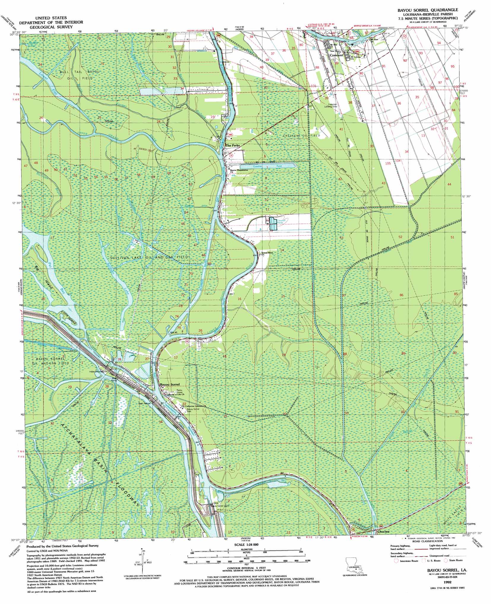
Bayou Sorrel Topo Map Louisiana
To zoom in, hover over the map of Bayou Sorrel
USGS Topo Quad 30091b3 - 1:24,000 scale
| Topo Map Name: | Bayou Sorrel |
| USGS Topo Quad ID: | 30091b3 |
| Print Size: | ca. 21 1/4" wide x 27" high |
| Southeast Coordinates: | 30.125° N latitude / 91.25° W longitude |
| Map Center Coordinates: | 30.1875° N latitude / 91.3125° W longitude |
| U.S. State: | LA |
| Filename: | o30091b3.jpg |
| Download Map JPG Image: | Bayou Sorrel topo map 1:24,000 scale |
| Map Type: | Topographic |
| Topo Series: | 7.5´ |
| Map Scale: | 1:24,000 |
| Source of Map Images: | United States Geological Survey (USGS) |
| Alternate Map Versions: |
Crescent LA 1953, updated 1954 Download PDF Buy paper map Crescent LA 1953, updated 1958 Download PDF Buy paper map Bayou Sorrel LA 1969, updated 1971 Download PDF Buy paper map Bayou Sorrel LA 1969, updated 1977 Download PDF Buy paper map Bayou Sorrel LA 1969, updated 1980 Download PDF Buy paper map Bayou Sorrel LA 1992, updated 1992 Download PDF Buy paper map Bayou Sorrel LA 2012 Download PDF Buy paper map Bayou Sorrel LA 2015 Download PDF Buy paper map |
1:24,000 Topo Quads surrounding Bayou Sorrel
Maringouin |
Grosse Tete |
Lobdell |
Baton Rouge West |
Baton Rouge East |
Cow Bayou |
Grosse Tete Sw |
Addis |
Plaquemine |
Saint Gabriel |
Lake Mongoulois |
Grand River |
Bayou Sorrel |
White Castle |
Carville |
Jackass Bay |
Lake Chicot |
Pigeon |
Lone Star |
Belle Rose |
Charenton |
Centerville Nw |
Centerville Ne |
Pierre Part |
Napoleonville |
> Back to 30091a1 at 1:100,000 scale
> Back to 30090a1 at 1:250,000 scale
> Back to U.S. Topo Maps home
Bayou Sorrel topo map: Gazetteer
Bayou Sorrel: Airports
Freeman Landing Strip elevation 1m 3′Bayou Sorrel: Bays
Pat Bay elevation 0m 0′Bayou Sorrel: Canals
Mound Ditch elevation 2m 6′Murrell Canal elevation 2m 6′
Wilberts Canal elevation 1m 3′
Wiseman Ditch elevation 1m 3′
Bayou Sorrel: Channels
Gulf Intracoastal Waterway elevation 0m 0′Bayou Sorrel: Dams
Bayou Sorrel Locks elevation 4m 13′Bayou Sorrel: Guts
Bayou Goula elevation 1m 3′Mound Bayou elevation 3m 9′
Bayou Sorrel: Islands
Big Island elevation 1m 3′Little Island elevation 0m 0′
Bayou Sorrel: Lakes
Lake Long elevation 0m 0′Middle Lake elevation 1m 3′
Sullivan Lake elevation 0m 0′
The Brakes elevation 2m 6′
Willow Lake elevation 1m 3′
Bayou Sorrel: Oilfields
Bull Tail Bayou Oil Field elevation 2m 6′Crescent Oil Field elevation 1m 3′
Grand River Gas Field elevation 1m 3′
Sullivan Lake Oil and Gas Field elevation 1m 3′
White Castle Oil Field elevation 1m 3′
Bayou Sorrel: Parks
Bayou Sorrel Park elevation 2m 6′Bayou Sorrel: Populated Places
Bayou Sorrel elevation 2m 6′Choctaw elevation 3m 9′
Crescent elevation 4m 13′
The Parks elevation 2m 6′
Bayou Sorrel: Streams
Bayou Farmer elevation 2m 6′Bayou Jacob elevation 0m 0′
Bayou Plaquemine elevation 0m 0′
Bayou Richard elevation 0m 0′
Bayou Sorrel elevation 1m 3′
Cross Bayou elevation 0m 0′
Salt Mine Bayou elevation 2m 6′
Upper Grand River elevation 0m 0′
Bayou Sorrel digital topo map on disk
Buy this Bayou Sorrel topo map showing relief, roads, GPS coordinates and other geographical features, as a high-resolution digital map file on DVD: