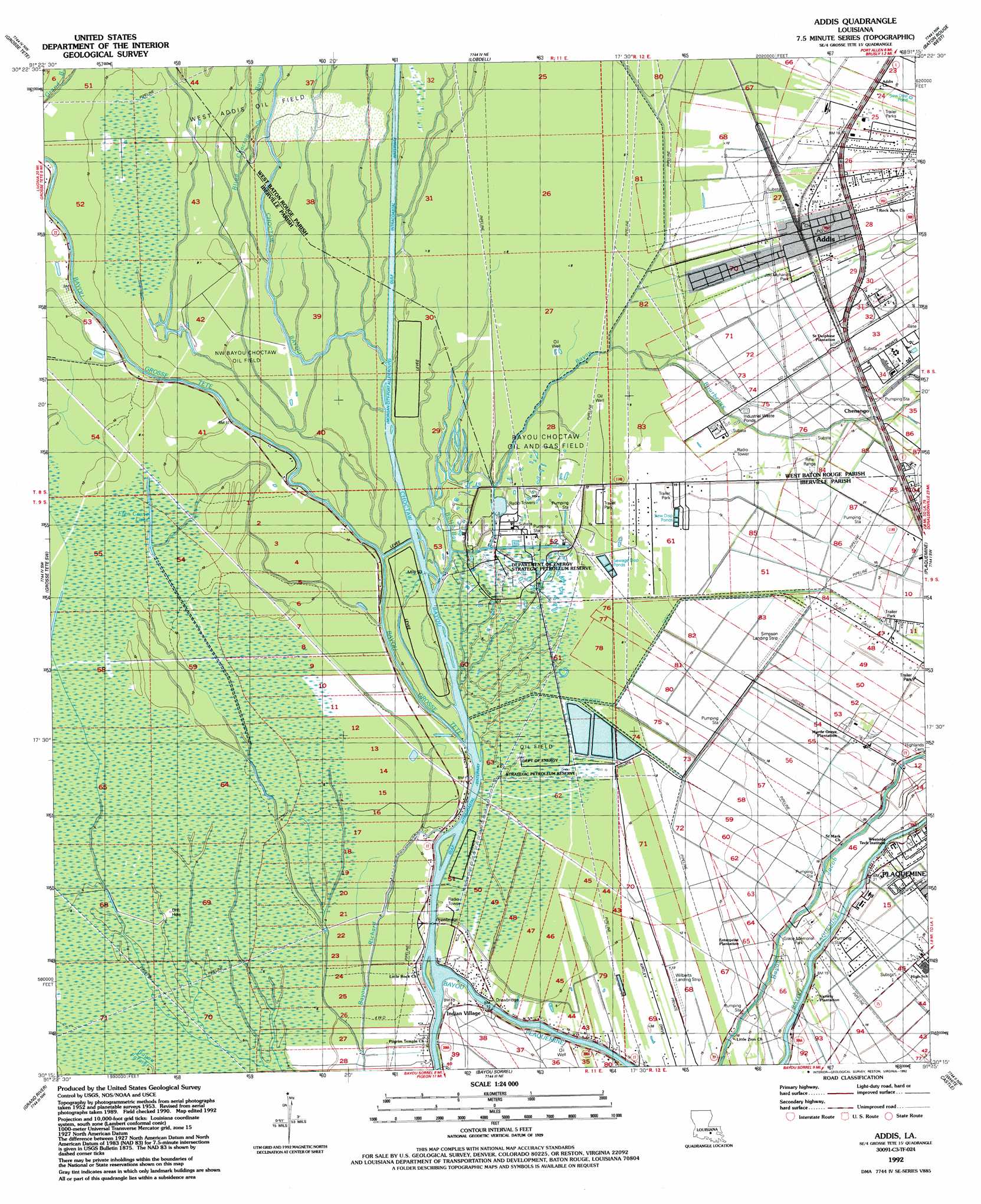
Addis Topo Map Louisiana
To zoom in, hover over the map of Addis
USGS Topo Quad 30091c3 - 1:24,000 scale
| Topo Map Name: | Addis |
| USGS Topo Quad ID: | 30091c3 |
| Print Size: | ca. 21 1/4" wide x 27" high |
| Southeast Coordinates: | 30.25° N latitude / 91.25° W longitude |
| Map Center Coordinates: | 30.3125° N latitude / 91.3125° W longitude |
| U.S. State: | LA |
| Filename: | o30091c3.jpg |
| Download Map JPG Image: | Addis topo map 1:24,000 scale |
| Map Type: | Topographic |
| Topo Series: | 7.5´ |
| Map Scale: | 1:24,000 |
| Source of Map Images: | United States Geological Survey (USGS) |
| Alternate Map Versions: |
Addis LA 1953, updated 1954 Download PDF Buy paper map Addis LA 1953, updated 1960 Download PDF Buy paper map Addis LA 1953, updated 1972 Download PDF Buy paper map Addis LA 1953, updated 1978 Download PDF Buy paper map Addis LA 1953, updated 1980 Download PDF Buy paper map Addis LA 1992, updated 1992 Download PDF Buy paper map Addis LA 2012 Download PDF Buy paper map Addis LA 2015 Download PDF Buy paper map |
1:24,000 Topo Quads surrounding Addis
Fordoche |
Erwinville |
Walls |
Scotlandville |
Comite |
Maringouin |
Grosse Tete |
Lobdell |
Baton Rouge West |
Baton Rouge East |
Cow Bayou |
Grosse Tete Sw |
Addis |
Plaquemine |
Saint Gabriel |
Lake Mongoulois |
Grand River |
Bayou Sorrel |
White Castle |
Carville |
Jackass Bay |
Lake Chicot |
Pigeon |
Lone Star |
Belle Rose |
> Back to 30091a1 at 1:100,000 scale
> Back to 30090a1 at 1:250,000 scale
> Back to U.S. Topo Maps home
Addis topo map: Gazetteer
Addis: Airports
Simpson Landing Strip elevation 1m 3′Wilberts Landing Strip elevation 4m 13′
Addis: Guts
Bull Bay elevation 2m 6′Addis: Lakes
Efen Crane Lake elevation 2m 6′Addis: Oilfields
Bayou Choctan Oil Field elevation 2m 6′Bayou Choctaw Oil Field elevation 1m 3′
Jacob Bayou Oil Field elevation 6m 19′
Northwest Bayou Choctaw Oilfield elevation 1m 3′
Plaquemine Bayou Gas Field elevation 4m 13′
West Addis Oil Field elevation 1m 3′
West Addis Oil Field elevation 2m 6′
Addis: Parks
Joe Myhand Park elevation 5m 16′Addis: Populated Places
Addis elevation 6m 19′Chenango elevation 5m 16′
Indian Village elevation 4m 13′
Mark (historical) elevation 7m 22′
Myrtle Grove Plantation elevation 6m 19′
Saint Delphine elevation 6m 19′
Addis: Post Offices
Addis Post Office elevation 6m 19′Addis: Streams
Bayou Bourbeaux elevation 0m 0′Bayou Grosse Tete elevation 0m 0′
Blind Choctaw Bayou elevation 0m 0′
Caney Bayou elevation 2m 6′
Choctaw Bayou elevation 0m 0′
Addis digital topo map on disk
Buy this Addis topo map showing relief, roads, GPS coordinates and other geographical features, as a high-resolution digital map file on DVD: