Baton Rouge East Topo Map Louisiana
To zoom in, hover over the map of Baton Rouge East
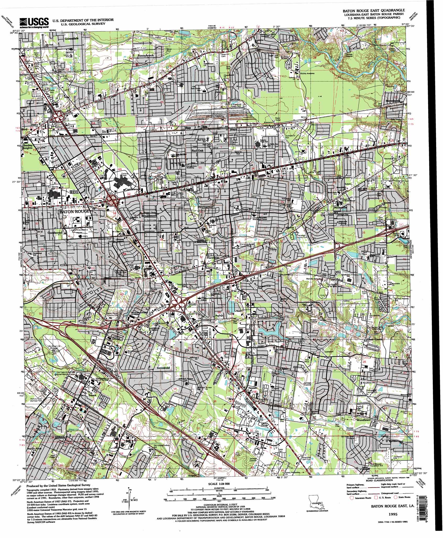
USGS Topo Quad 30091d1 - 1:24,000 scale
| Topo Map Name: | Baton Rouge East |
| USGS Topo Quad ID: | 30091d1 |
| Print Size: | ca. 21 1/4" wide x 27" high |
| Southeast Coordinates: | 30.375° N latitude / 91° W longitude |
| Map Center Coordinates: | 30.4375° N latitude / 91.0625° W longitude |
| U.S. State: | LA |
| Filename: | o30091d1.jpg |
| Download Map JPG Image: | Baton Rouge East topo map 1:24,000 scale |
| Map Type: | Topographic |
| Topo Series: | 7.5´ |
| Map Scale: | 1:24,000 |
| Source of Map Images: | United States Geological Survey (USGS) |
| Alternate Map Versions: |
Baton Rouge East LA 1953, updated 1954 Download PDF Buy paper map Baton Rouge East LA 1963, updated 1964 Download PDF Buy paper map Baton Rouge East LA 1963, updated 1968 Download PDF Buy paper map Baton Rouge East LA 1963, updated 1971 Download PDF Buy paper map Baton Rouge East LA 1963, updated 1981 Download PDF Buy paper map Baton Rouge East LA 1963, updated 1989 Download PDF Buy paper map Baton Rouge East LA 1992, updated 1992 Download PDF Buy paper map Baton Rouge East LA 1992, updated 1992 Download PDF Buy paper map Baton Rouge East LA 1995, updated 1998 Download PDF Buy paper map Baton Rouge East LA 2012 Download PDF Buy paper map Baton Rouge East LA 2015 Download PDF Buy paper map |
1:24,000 Topo Quads surrounding Baton Rouge East
Port Hudson |
Zachary |
Fred |
Pride |
Pine Grove |
Walls |
Scotlandville |
Comite |
Watson |
Satsuma |
Lobdell |
Baton Rouge West |
Baton Rouge East |
Denham Springs |
Walker |
Addis |
Plaquemine |
Saint Gabriel |
Prairieville |
French Settlement |
Bayou Sorrel |
White Castle |
Carville |
Gonzales |
Sorrento |
> Back to 30091a1 at 1:100,000 scale
> Back to 30090a1 at 1:250,000 scale
> Back to U.S. Topo Maps home
Baton Rouge East topo map: Gazetteer
Baton Rouge East: Airports
Butch Baum Heliport elevation 16m 52′Jenkins Heliport elevation 15m 49′
Medical Center of Baton Rouge Heliport elevation 12m 39′
Our Lady of the Lake RMC Heliport elevation 9m 29′
Region 1 Headquarters-State Police Heliport elevation 17m 55′
Southern Helicopters Heliport elevation 9m 29′
Transcontinental Gas Pipeline Corp Heliport elevation 16m 52′
Troop A Heliport elevation 13m 42′
Baton Rouge East: Bridges
Trajer Bridge elevation 7m 22′Baton Rouge East: Crossings
Interchange 159 elevation 11m 36′Interchange 160 elevation 11m 36′
Interchange 162 elevation 10m 32′
Interchange 163 elevation 10m 32′
Interchange 1A elevation 11m 36′
Interchange 1B elevation 10m 32′
Interchange 2 elevation 14m 45′
Interchange 4 elevation 15m 49′
Interchange 7 elevation 12m 39′
Baton Rouge East: Oilfields
Nesser Oil Field elevation 9m 29′Siegan Oil Field elevation 11m 36′
Baton Rouge East: Parks
Barringer Road Park elevation 11m 36′Bon Marche Community Park elevation 16m 52′
Camelot Park elevation 12m 39′
Cedarcrest Park elevation 14m 45′
Drusilla Park elevation 13m 42′
Duchess Drive Park elevation 13m 42′
Eastgate Drive Park elevation 12m 39′
Fiesta Park elevation 15m 49′
Flannery Road Park elevation 14m 45′
Forest Park elevation 12m 39′
Independence Park elevation 14m 45′
Jefferson Terrace Park elevation 11m 36′
Judson Baptist Recreation Park elevation 16m 52′
LaFitte Street Park elevation 11m 36′
Lanier Drive Park elevation 14m 45′
Mayfair Park elevation 6m 19′
North Sherwood Forest Park elevation 15m 49′
Old Hammond Highway Park elevation 11m 36′
Parklawn Park elevation 12m 39′
Parkview Park elevation 13m 42′
Perkins Road Olympia Field elevation 6m 19′
Red Oaks Park elevation 15m 49′
Samuel D'Agostino Park elevation 15m 49′
Sata Park elevation 16m 52′
Sharp Road Park elevation 13m 42′
Sugar Land Park elevation 14m 45′
Tams Drive Park elevation 14m 45′
Thomas A Maher Park elevation 15m 49′
Wray Park elevation 14m 45′
Baton Rouge East: Populated Places
Acadian Place elevation 14m 45′Acadiana elevation 14m 45′
Afton Oaks elevation 12m 39′
Airline Acres elevation 13m 42′
Antioch Villa elevation 8m 26′
Ashley elevation 14m 45′
Aubin elevation 13m 42′
Audubon Terrace elevation 9m 29′
Avalon elevation 13m 42′
Beacon Hill elevation 14m 45′
Bell Fontaine elevation 14m 45′
Bell Grove Place elevation 7m 22′
Bird elevation 16m 52′
Bocage elevation 15m 49′
Bonaire elevation 10m 32′
Brandon Hollow elevation 10m 32′
Brashears (historical) elevation 14m 45′
Briar Place elevation 9m 29′
Bristol elevation 17m 55′
Broadmoor elevation 15m 49′
Broadmoor Estates elevation 14m 45′
Broadmoor Forest elevation 13m 42′
Broadmoor Place elevation 14m 45′
Broadmoor Plaza elevation 14m 45′
Broadmoor Terrace elevation 13m 42′
Burden Estates elevation 10m 32′
Camelot elevation 12m 39′
Carmen Terrace elevation 12m 39′
Castlewood elevation 15m 49′
Cedarcrest elevation 15m 49′
Centurion Place elevation 13m 42′
Clearmont elevation 16m 52′
Cloverland elevation 8m 26′
Country Club Estates elevation 14m 45′
Country Manor elevation 12m 39′
Country Road elevation 15m 49′
Courtland Place elevation 14m 45′
Darius Place elevation 14m 45′
Del Rey Plaza elevation 9m 29′
Donwood elevation 13m 42′
Drusilla Place elevation 15m 49′
East Broadmoor elevation 15m 49′
East Sherwood Forest elevation 14m 45′
Eastgate elevation 12m 39′
Essen elevation 11m 36′
Essen Plaza elevation 9m 29′
Essen South elevation 8m 26′
Executive Park elevation 16m 52′
Fairmont elevation 13m 42′
Florida Plaza elevation 15m 49′
Forest Hill elevation 10m 32′
Forest Oaks elevation 15m 49′
Fox Run elevation 9m 29′
Goodwood elevation 15m 49′
Goodwood Estates elevation 16m 52′
Goodwood Homesites elevation 16m 52′
Green Back Forest elevation 7m 22′
Greenway Place elevation 14m 45′
Greenwell Forest elevation 14m 45′
Harelson elevation 15m 49′
Hickory Ridge elevation 12m 39′
Hillcrest Acres elevation 13m 42′
Hillside elevation 8m 26′
Howell Park elevation 16m 52′
Independence Place elevation 15m 49′
Inniswold elevation 9m 29′
Inniswold Estates elevation 9m 29′
Jefferson Place elevation 15m 49′
Jefferson Shadows elevation 14m 45′
Jefferson Terrace elevation 10m 32′
Jefferson Terrace East elevation 10m 32′
Jones Creek elevation 12m 39′
Keaty Place elevation 13m 42′
Kildare elevation 16m 52′
Kings Hill elevation 8m 26′
Kingsbridge elevation 13m 42′
La Belle Aire elevation 14m 45′
Lake Forest Park elevation 12m 39′
Lake Sherwood Acres elevation 11m 36′
Lakeview Estates elevation 13m 42′
Land O'Lakes elevation 13m 42′
Laurel Lea elevation 12m 39′
Li Rocchi elevation 11m 36′
Longwood elevation 16m 52′
Lynwood Village elevation 9m 29′
Madeline Court elevation 14m 45′
Magellan Place elevation 13m 42′
Magnolia Woods elevation 11m 36′
Maribel Village elevation 16m 52′
Mayfair Heights elevation 12m 39′
Mayfair Park elevation 11m 36′
Mayfair Park North elevation 9m 29′
McGehee Place elevation 14m 45′
McLemore Acres elevation 13m 42′
Melrose East elevation 16m 52′
Millerville elevation 12m 39′
Monterrey Park elevation 14m 45′
Monticello elevation 15m 49′
Morning Glen elevation 7m 22′
Nesser elevation 12m 39′
Normandy Acres elevation 16m 52′
North Red Oaks elevation 14m 45′
North Sherwood Forest elevation 14m 45′
Oak Forest elevation 16m 52′
Oak Hill elevation 14m 45′
Oak Park elevation 15m 49′
Oak Valley elevation 15m 49′
Oakcrest elevation 17m 55′
Oakwood Forest elevation 16m 52′
Old Jefferson elevation 9m 29′
O'Neal Place elevation 11m 36′
Orr (historical) elevation 13m 42′
Oxford Place elevation 14m 45′
Palm Hills elevation 15m 49′
Park Forest elevation 15m 49′
Park Forest East elevation 16m 52′
Park Plaza elevation 14m 45′
Parkland Terrace elevation 14m 45′
Parkview East elevation 14m 45′
Parkview Oaks elevation 13m 42′
Parkview Oaks South elevation 13m 42′
Partridge Lane Heights elevation 14m 45′
Pasadena elevation 17m 55′
Perkins Place elevation 10m 32′
Pine Park elevation 9m 29′
Pioneer Park elevation 16m 52′
Plaza 12 Garden Homes elevation 14m 45′
Quail Run elevation 12m 39′
Randolph Heights elevation 15m 49′
Red Oak elevation 15m 49′
Riffel Place elevation 15m 49′
River Oaks elevation 13m 42′
Royal Oak elevation 12m 39′
Rushmore elevation 14m 45′
Saint James elevation 14m 45′
Sarasota Place elevation 15m 49′
Shadowbrook elevation 12m 39′
Shamrock Gardens elevation 15m 49′
Shamrock Plaza elevation 16m 52′
Sharp elevation 16m 52′
Shenandoah elevation 12m 39′
Shenandoah North elevation 12m 39′
Shenandoah Park elevation 11m 36′
Shenandoah Square elevation 12m 39′
Sherwood Forest elevation 13m 42′
Sherwood Forest Estates elevation 13m 42′
Sherwood Garden Homes elevation 12m 39′
Sherwood Manor elevation 13m 42′
Sherwood Meadow elevation 13m 42′
Sherwood Oaks elevation 13m 42′
Sherwood Oaks South elevation 13m 42′
Shiloh elevation 12m 39′
Silverside elevation 12m 39′
Silverside Heights Garden elevation 9m 29′
South Broadmoor elevation 14m 45′
South Highlands elevation 11m 36′
South River Oaks elevation 13m 42′
South Sherwood Forest elevation 12m 39′
Southmoore elevation 15m 49′
Southpark elevation 14m 45′
Staring Acres elevation 11m 36′
Stevendale Estates elevation 12m 39′
Stevendale Heights elevation 14m 45′
Stevendale Park elevation 13m 42′
Stevensdale elevation 13m 42′
Sunnybrook elevation 14m 45′
Tara elevation 13m 42′
Tara Place elevation 16m 52′
The Hideaway elevation 13m 42′
The Hill elevation 14m 45′
The Woodlands elevation 12m 39′
Victoria Farm elevation 14m 45′
Victoria Garden elevation 16m 52′
Videt Place elevation 16m 52′
Villa Del Rey elevation 14m 45′
Villa Del Rey Park elevation 14m 45′
Village Cote elevation 13m 42′
Walden elevation 7m 22′
Wedgewood elevation 11m 36′
Wellington elevation 13m 42′
West River Oaks elevation 12m 39′
West Sherwood Forest elevation 13m 42′
Westminster elevation 8m 26′
Wickland Terrace elevation 13m 42′
Wimbledon Estates elevation 9m 29′
Windfall elevation 16m 52′
Windsor Place elevation 13m 42′
Woodcrest elevation 13m 42′
Wooddale East elevation 15m 49′
Woodland Ridge elevation 12m 39′
Woodland Ridge Park elevation 11m 36′
Woodlawn elevation 12m 39′
Woodlawn Acres elevation 7m 22′
Woodlawn Estates elevation 12m 39′
Woodshire Village elevation 12m 39′
Baton Rouge East: Streams
Beaver Bayou elevation 8m 26′Dawson Creek elevation 4m 13′
Draughan Creek elevation 9m 29′
Jacks Bayou elevation 9m 29′
Knox Branch elevation 6m 19′
Lively Bayou elevation 11m 36′
North Branch Ward Creek elevation 10m 32′
Weiner Creek elevation 7m 22′
Baton Rouge East digital topo map on disk
Buy this Baton Rouge East topo map showing relief, roads, GPS coordinates and other geographical features, as a high-resolution digital map file on DVD: