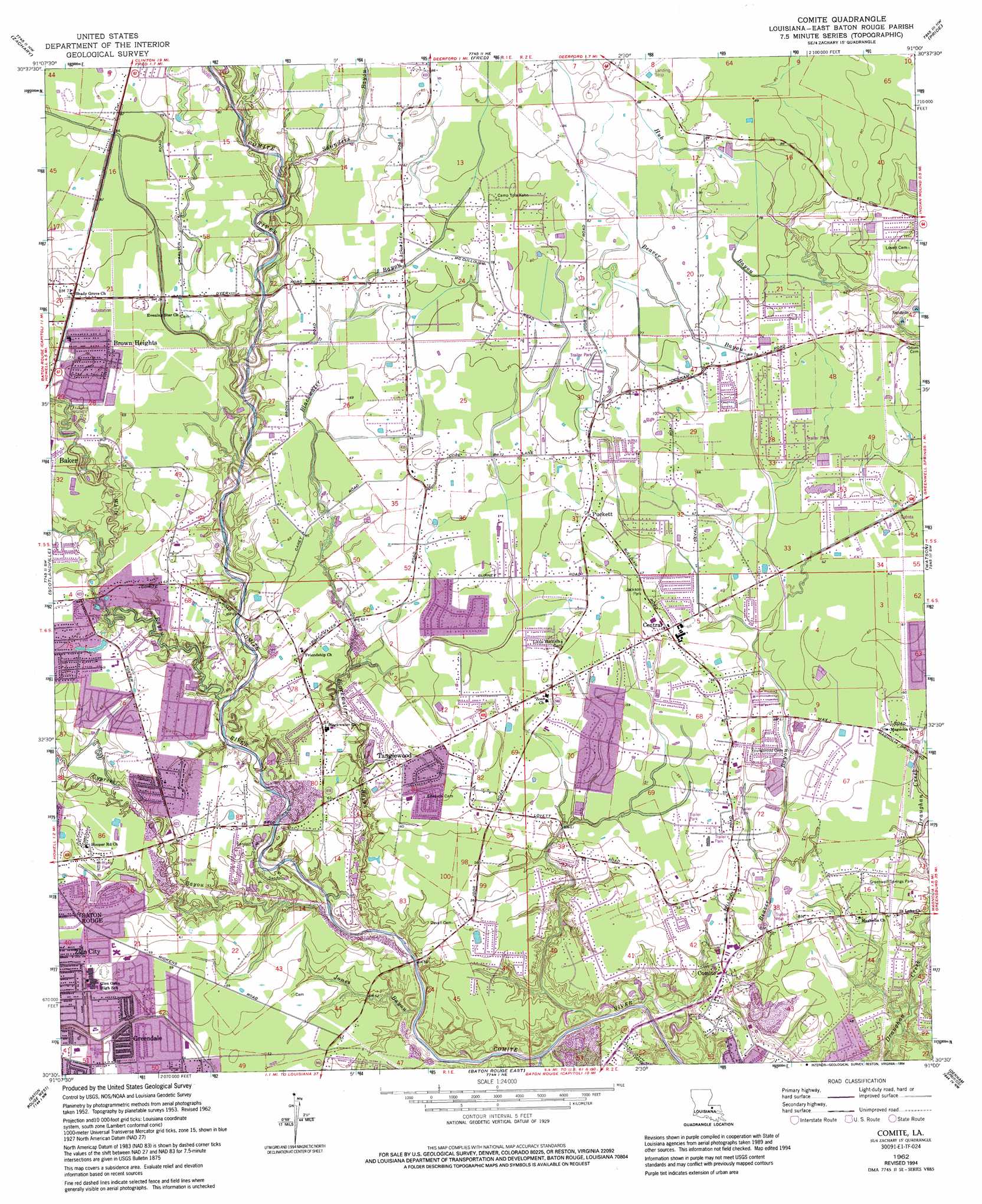
Comite Topo Map Louisiana
To zoom in, hover over the map of Comite
USGS Topo Quad 30091e1 - 1:24,000 scale
| Topo Map Name: | Comite |
| USGS Topo Quad ID: | 30091e1 |
| Print Size: | ca. 21 1/4" wide x 27" high |
| Southeast Coordinates: | 30.5° N latitude / 91° W longitude |
| Map Center Coordinates: | 30.5625° N latitude / 91.0625° W longitude |
| U.S. State: | LA |
| Filename: | o30091e1.jpg |
| Download Map JPG Image: | Comite topo map 1:24,000 scale |
| Map Type: | Topographic |
| Topo Series: | 7.5´ |
| Map Scale: | 1:24,000 |
| Source of Map Images: | United States Geological Survey (USGS) |
| Alternate Map Versions: |
Comite LA 1953, updated 1954 Download PDF Buy paper map Comite LA 1953, updated 1959 Download PDF Buy paper map Comite LA 1962, updated 1964 Download PDF Buy paper map Comite LA 1962, updated 1968 Download PDF Buy paper map Comite LA 1962, updated 1971 Download PDF Buy paper map Comite LA 1962, updated 1980 Download PDF Buy paper map Comite LA 1962, updated 1994 Download PDF Buy paper map Comite LA 1996, updated 1999 Download PDF Buy paper map Comite LA 2012 Download PDF Buy paper map Comite LA 2015 Download PDF Buy paper map |
1:24,000 Topo Quads surrounding Comite
Elm Park |
Jackson |
Clinton |
Bluff Creek |
Hatchersville |
Port Hudson |
Zachary |
Fred |
Pride |
Pine Grove |
Walls |
Scotlandville |
Comite |
Watson |
Satsuma |
Lobdell |
Baton Rouge West |
Baton Rouge East |
Denham Springs |
Walker |
Addis |
Plaquemine |
Saint Gabriel |
Prairieville |
French Settlement |
> Back to 30091e1 at 1:100,000 scale
> Back to 30090a1 at 1:250,000 scale
> Back to U.S. Topo Maps home
Comite topo map: Gazetteer
Comite: Airports
Flying J Ranch Airport elevation 26m 85′Triangle J Airport elevation 20m 65′
Comite: Dams
Brown Heights Pond Dam elevation 21m 68′Comite: Parks
Brown Heights Park elevation 21m 68′Comite River Park elevation 15m 49′
Greenwell Springs Park elevation 16m 52′
Hooper Park elevation 18m 59′
Howard Park elevation 20m 65′
Jackson Park elevation 20m 65′
James Watson Park elevation 15m 49′
Laurens H Cohn Arboretum elevation 20m 65′
Comite: Populated Places
Alford Acres elevation 17m 55′Beabois Place elevation 23m 75′
Biltmore elevation 18m 59′
Boganvilla elevation 18m 59′
Bon Dickey elevation 18m 59′
Brandon Place elevation 15m 49′
Brian Estates elevation 16m 52′
Bridlewood elevation 20m 65′
Brown Heights elevation 21m 68′
Brownfields elevation 19m 62′
Carmel Acres elevation 19m 62′
Cedar Mill Run elevation 17m 55′
Centerra elevation 19m 62′
Central elevation 20m 65′
Central Estates elevation 19m 62′
Central Place elevation 18m 59′
Cimmaron elevation 18m 59′
Comite elevation 15m 49′
Comite Estates elevation 16m 52′
Comite Hills elevation 17m 55′
Comite Hills West elevation 18m 59′
Country Estate Acres elevation 22m 72′
Crystal Place elevation 21m 68′
East Fairlane elevation 16m 52′
East Glen elevation 15m 49′
East Ridgewood elevation 15m 49′
El Ranchito elevation 21m 68′
Forest Glen Estates elevation 14m 45′
Forest Heights Park elevation 16m 52′
Forest Park elevation 18m 59′
Glen Oaks Place elevation 19m 62′
Glenbrook elevation 12m 39′
Green Acres elevation 19m 62′
Green Gate elevation 20m 65′
Greendale elevation 16m 52′
Greenwell Acres East elevation 16m 52′
Greenwood elevation 19m 62′
Greenwood Estates elevation 20m 65′
Hidden Creek elevation 21m 68′
Holiday Woods elevation 19m 62′
Huntington Park elevation 22m 72′
Huntley Place elevation 18m 59′
Jackson Park elevation 19m 62′
Jackson Place elevation 20m 65′
Klienpeter Terrace elevation 21m 68′
Lazy Lake Estates elevation 18m 59′
Merrydale elevation 16m 52′
Mickens Place elevation 18m 59′
Monhegan elevation 18m 59′
Morgan Place elevation 18m 59′
Morgan Place West elevation 19m 62′
Myrick Place elevation 19m 62′
Northeast Place elevation 22m 72′
Oak Cluster elevation 14m 45′
Oak Shadows Place elevation 16m 52′
Pecan Ridge elevation 18m 59′
Phebus elevation 15m 49′
Pinewood Acres elevation 23m 75′
Plantation Way elevation 25m 82′
Pleasant Hills elevation 20m 65′
Puckett elevation 21m 68′
Rambling Oaks elevation 22m 72′
Ridgewood elevation 15m 49′
Sherrington Place elevation 22m 72′
Ski Stone elevation 21m 68′
South Merrydale elevation 17m 55′
Tanglewood elevation 17m 55′
Twin Oaks elevation 20m 65′
Waters Edge elevation 20m 65′
Welcome Heights elevation 20m 65′
Whispering Oaks elevation 17m 55′
White Oak Run elevation 21m 68′
Willow Creek elevation 16m 52′
Willowood Acres elevation 19m 62′
Winchester elevation 16m 52′
Woodland View elevation 17m 55′
Woods Edge elevation 16m 52′
Yorkdale elevation 21m 68′
Comite: Reservoirs
Brown Heights Pond elevation 21m 68′Comite: Streams
Blackwater Bayou elevation 8m 26′Cypress Bayou elevation 8m 26′
Hurricane Creek elevation 6m 19′
Jones Bayou elevation 7m 22′
Saunders Bayou elevation 18m 59′
White Bayou elevation 14m 45′
Comite digital topo map on disk
Buy this Comite topo map showing relief, roads, GPS coordinates and other geographical features, as a high-resolution digital map file on DVD: