Lottie Topo Map Louisiana
To zoom in, hover over the map of Lottie
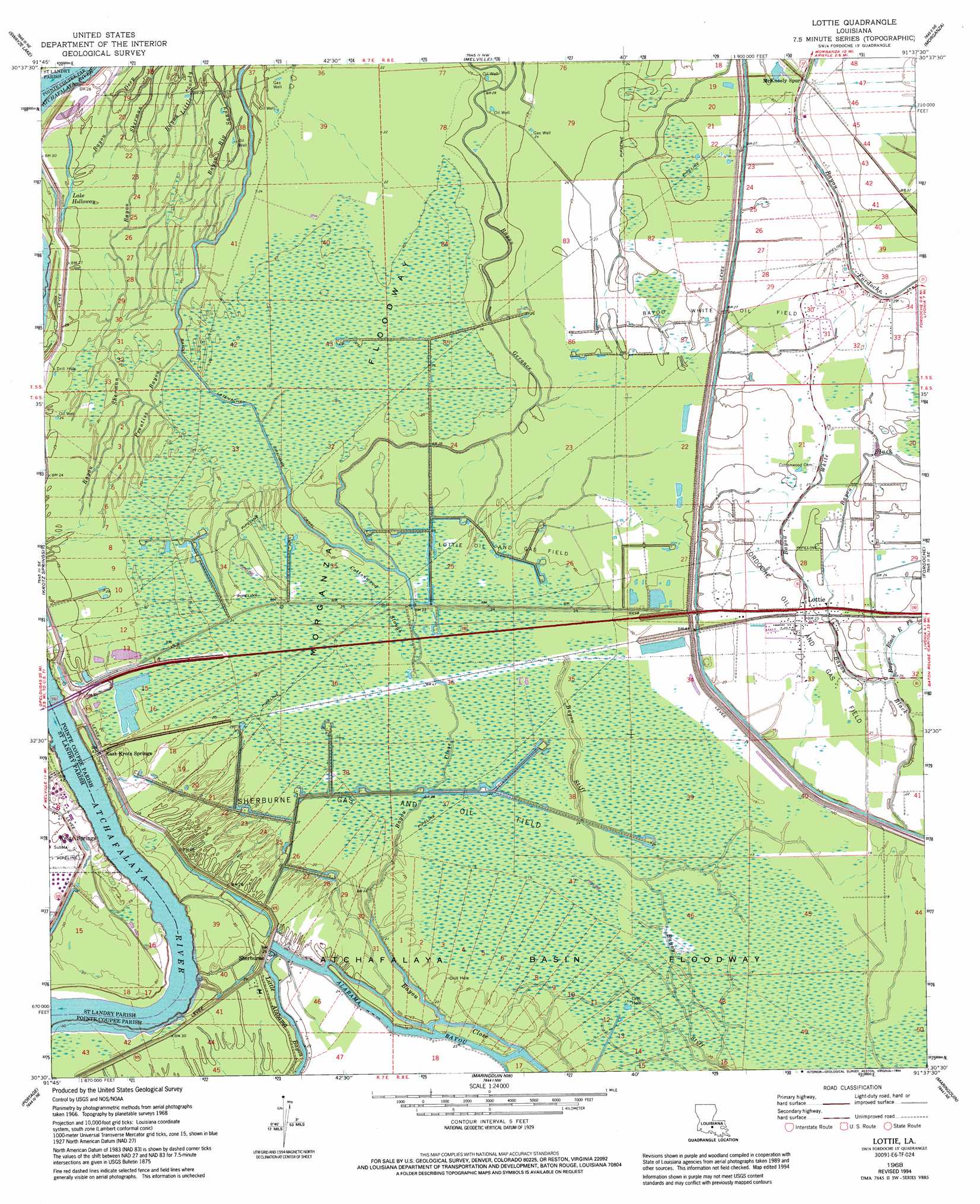
USGS Topo Quad 30091e6 - 1:24,000 scale
| Topo Map Name: | Lottie |
| USGS Topo Quad ID: | 30091e6 |
| Print Size: | ca. 21 1/4" wide x 27" high |
| Southeast Coordinates: | 30.5° N latitude / 91.625° W longitude |
| Map Center Coordinates: | 30.5625° N latitude / 91.6875° W longitude |
| U.S. State: | LA |
| Filename: | o30091e6.jpg |
| Download Map JPG Image: | Lottie topo map 1:24,000 scale |
| Map Type: | Topographic |
| Topo Series: | 7.5´ |
| Map Scale: | 1:24,000 |
| Source of Map Images: | United States Geological Survey (USGS) |
| Alternate Map Versions: |
Lottie LA 1968, updated 1969 Download PDF Buy paper map Lottie LA 1968, updated 1994 Download PDF Buy paper map Lottie LA 2012 Download PDF Buy paper map Lottie LA 2015 Download PDF Buy paper map |
1:24,000 Topo Quads surrounding Lottie
Bayou Jack |
Bayou Current |
Batchelor |
Lacour |
Saint Francisville |
Palmetto |
Swayze Lake |
Melville |
Morganza |
New Roads |
Port Barre |
Krotz Springs |
Lottie |
Fordoche |
Erwinville |
Arnaudville |
Portage |
Maringouin Nw |
Maringouin |
Grosse Tete |
Breaux Bridge |
Cecilia |
Butte La Rose |
Cow Bayou |
Grosse Tete Sw |
> Back to 30091e1 at 1:100,000 scale
> Back to 30090a1 at 1:250,000 scale
> Back to U.S. Topo Maps home
Lottie topo map: Gazetteer
Lottie: Lakes
Lake Holloway elevation 7m 22′Lottie: Oilfields
Bayou White Oil Field elevation 7m 22′Gerance Bayou Oil Field elevation 7m 22′
Latenache Bayou Oil and Gas Field elevation 7m 22′
Lottie Oil and Gas Field elevation 5m 16′
Sherburne Gas and Oil Field elevation 5m 16′
Lottie: Parks
Sherburne Wildlife Management Area elevation 7m 22′Lottie: Populated Places
Aline elevation 9m 29′Elliot City (historical) elevation 5m 16′
Lottie elevation 9m 29′
Sherburne elevation 8m 26′
Lottie: Post Offices
Lottie Post Office elevation 8m 26′Lottie: Streams
Alabama Bayou elevation 1m 3′Bayou Black East Fork elevation 7m 22′
Bayou Close elevation 5m 16′
Bayou Gerance elevation 6m 19′
Bayou White elevation 8m 26′
Cottonwood Slough elevation 5m 16′
Little Alabama Bayou elevation 7m 22′
Prentiss Bayou elevation 6m 19′
Lottie digital topo map on disk
Buy this Lottie topo map showing relief, roads, GPS coordinates and other geographical features, as a high-resolution digital map file on DVD: