Morganza Topo Map Louisiana
To zoom in, hover over the map of Morganza
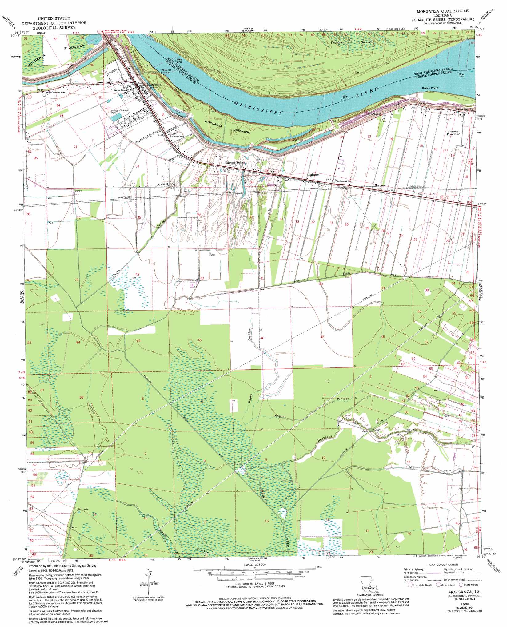
USGS Topo Quad 30091f5 - 1:24,000 scale
| Topo Map Name: | Morganza |
| USGS Topo Quad ID: | 30091f5 |
| Print Size: | ca. 21 1/4" wide x 27" high |
| Southeast Coordinates: | 30.625° N latitude / 91.5° W longitude |
| Map Center Coordinates: | 30.6875° N latitude / 91.5625° W longitude |
| U.S. State: | LA |
| Filename: | o30091f5.jpg |
| Download Map JPG Image: | Morganza topo map 1:24,000 scale |
| Map Type: | Topographic |
| Topo Series: | 7.5´ |
| Map Scale: | 1:24,000 |
| Source of Map Images: | United States Geological Survey (USGS) |
| Alternate Map Versions: |
Morganza LA 1968, updated 1970 Download PDF Buy paper map Morganza LA 1968, updated 1978 Download PDF Buy paper map Morganza LA 1968, updated 1994 Download PDF Buy paper map Morganza LA 2012 Download PDF Buy paper map Morganza LA 2015 Download PDF Buy paper map |
1:24,000 Topo Quads surrounding Morganza
Simmesport |
Innis |
Tunica |
Weyanoke |
Laurel Hill |
Bayou Current |
Batchelor |
Lacour |
Saint Francisville |
Elm Park |
Swayze Lake |
Melville |
Morganza |
New Roads |
Port Hudson |
Krotz Springs |
Lottie |
Fordoche |
Erwinville |
Walls |
Portage |
Maringouin Nw |
Maringouin |
Grosse Tete |
Lobdell |
> Back to 30091e1 at 1:100,000 scale
> Back to 30090a1 at 1:250,000 scale
> Back to U.S. Topo Maps home
Morganza topo map: Gazetteer
Morganza: Bends
Morgans Bend elevation 6m 19′Morganza: Canals
Portage Canal elevation 3m 9′Portage Canal Number Two elevation 5m 16′
Morganza: Capes
Boies Point elevation 6m 19′Morganza: Dams
Louisiana Noname 47 Dam elevation 11m 36′Morganza: Flats
Morganza Floodway elevation 9m 29′Morganza: Levees
Boies Point Revetment elevation 10m 32′Morganza Revetment elevation 6m 19′
Morganza: Oilfields
Judge Digby Gas Field elevation 7m 22′Moore-Sams Oil Field elevation 8m 26′
Morganza: Populated Places
Angeles Plantation elevation 9m 29′Brownview elevation 10m 32′
Brunswick Plantation elevation 10m 32′
Dawson Switch elevation 11m 36′
Kelsey elevation 9m 29′
Labarre elevation 10m 32′
Morganza elevation 11m 36′
Morganza Landing elevation 13m 42′
Morrison elevation 9m 29′
Samuels elevation 9m 29′
Stewart Plantation elevation 10m 32′
Stonewell Plantation elevation 11m 36′
Zugg (historical) elevation 5m 16′
Morganza: Post Offices
Labarre Post Office elevation 10m 32′Morganza: Streams
Bayou Barre elevation 5m 16′Bayou Leskine elevation 5m 16′
Buckhorn Bayou elevation 4m 13′
Morganza: Valleys
Morganza Crevasse elevation 13m 42′Morganza digital topo map on disk
Buy this Morganza topo map showing relief, roads, GPS coordinates and other geographical features, as a high-resolution digital map file on DVD: