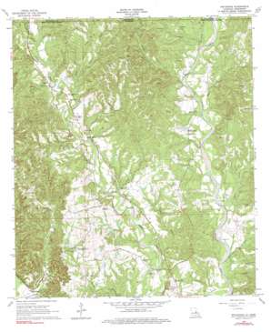
Weyanoke Topo Map Louisiana
To zoom in, hover over the map of Weyanoke
USGS Topo Quad 30091h4 - 1:24,000 scale
| Topo Map Name: | Weyanoke |
| USGS Topo Quad ID: | 30091h4 |
| Print Size: | ca. 21 1/4" wide x 27" high |
| Southeast Coordinates: | 30.875° N latitude / 91.375° W longitude |
| Map Center Coordinates: | 30.9375° N latitude / 91.4375° W longitude |
| U.S. States: | LA, MS |
| Filename: | o30091h4.jpg |
| Download Map JPG Image: | Weyanoke topo map 1:24,000 scale |
| Map Type: | Topographic |
| Topo Series: | 7.5´ |
| Map Scale: | 1:24,000 |
| Source of Map Images: | United States Geological Survey (USGS) |
| Alternate Map Versions: |
Weyanoke LA 1965, updated 1966 Download PDF Buy paper map Weyanoke LA 1965, updated 1976 Download PDF Buy paper map Weyanoke LA 1998, updated 2002 Download PDF Buy paper map Weyanoke LA 2012 Download PDF Buy paper map Weyanoke LA 2015 Download PDF Buy paper map |
1:24,000 Topo Quads surrounding Weyanoke
> Back to 30091e1 at 1:100,000 scale
> Back to 30090a1 at 1:250,000 scale
> Back to U.S. Topo Maps home
Weyanoke topo map: Gazetteer
Weyanoke: Areas
Sleepy Hollow Woods elevation 83m 272′Weyanoke: Oilfields
Bayou Sara Oil Field elevation 50m 164′Weyanoke: Parks
Tunica Hills State Wildlife Management Area elevation 40m 131′Weyanoke: Populated Places
Flower Hill elevation 45m 147′Hollywood elevation 58m 190′
Plettenberg elevation 16m 52′
Retreat elevation 65m 213′
Rosebank elevation 49m 160′
Turnbull elevation 56m 183′
Weyanoke elevation 46m 150′
Weyanoke: Post Offices
Hollywood Post Office (historical) elevation 61m 200′Plettenburg Post Office elevation 55m 180′
Retreat Post Office (historical) elevation 57m 187′
Turnbull Post Office (historical) elevation 62m 203′
Weyanoke Post Office (historical) elevation 52m 170′
Weyanoke: Streams
Baker Creek elevation 45m 147′Baker Creek elevation 47m 154′
Bean Branch elevation 41m 134′
Bell Creek elevation 41m 134′
East Fork Baker Creek elevation 56m 183′
East Fork Baker Creek elevation 56m 183′
Gales Creek elevation 37m 121′
Gales Creek elevation 37m 121′
Jones Branch elevation 27m 88′
Judas Branch elevation 66m 216′
Judas Branch elevation 54m 177′
Kimball Creek elevation 55m 180′
Kimball Creek elevation 58m 190′
Lucy Creek elevation 38m 124′
Sandy Creek elevation 45m 147′
Sandy Creek elevation 42m 137′
Scott Creek elevation 30m 98′
Stockfarm Creek elevation 44m 144′
Stockfarm Creek elevation 45m 147′
Williams Creek elevation 22m 72′
Weyanoke digital topo map on disk
Buy this Weyanoke topo map showing relief, roads, GPS coordinates and other geographical features, as a high-resolution digital map file on DVD:


