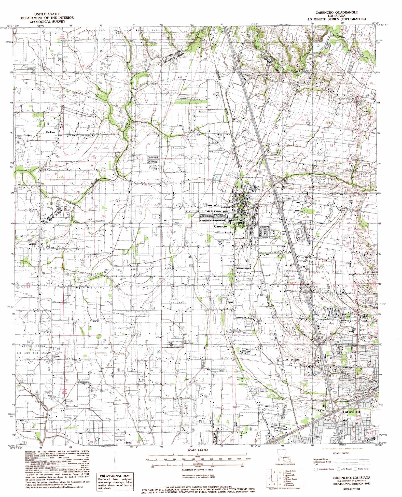
Carencro Topo Map Louisiana
To zoom in, hover over the map of Carencro
USGS Topo Quad 30092c1 - 1:24,000 scale
| Topo Map Name: | Carencro |
| USGS Topo Quad ID: | 30092c1 |
| Print Size: | ca. 21 1/4" wide x 27" high |
| Southeast Coordinates: | 30.25° N latitude / 92° W longitude |
| Map Center Coordinates: | 30.3125° N latitude / 92.0625° W longitude |
| U.S. State: | LA |
| Filename: | o30092c1.jpg |
| Download Map JPG Image: | Carencro topo map 1:24,000 scale |
| Map Type: | Topographic |
| Topo Series: | 7.5´ |
| Map Scale: | 1:24,000 |
| Source of Map Images: | United States Geological Survey (USGS) |
| Alternate Map Versions: |
Carencro LA 1983, updated 1983 Download PDF Buy paper map Carencro LA 1983, updated 1983 Download PDF Buy paper map Carencro LA 1998, updated 2002 Download PDF Buy paper map Carencro LA 2012 Download PDF Buy paper map Carencro LA 2015 Download PDF Buy paper map |
1:24,000 Topo Quads surrounding Carencro
Chataignier |
Lawtell |
Opelousas |
Port Barre |
Krotz Springs |
Richard |
Church Point |
Sunset |
Arnaudville |
Portage |
Branch |
Mire |
Carencro |
Breaux Bridge |
Cecilia |
Crowley East |
Duson |
Lafayette |
Broussard |
Parks |
Kaplan North |
Leroy |
Milton |
Youngsville |
New Iberia North |
> Back to 30092a1 at 1:100,000 scale
> Back to 30092a1 at 1:250,000 scale
> Back to U.S. Topo Maps home
Carencro topo map: Gazetteer
Carencro: Bridges
Broussard Bridge elevation 8m 26′Guidrys Bridge elevation 11m 36′
Carencro: Crossings
Interchange 101 elevation 13m 42′Interchange 103 elevation 12m 39′
Carencro: Oilfields
Cankton Gas Field elevation 13m 42′North Cankton Oil and Gas Field elevation 13m 42′
North Ossun Oil Field elevation 10m 32′
Vatican Oil Field elevation 12m 39′
Carencro: Parks
Moore Park elevation 14m 45′Pelican Park elevation 14m 45′
Carencro: Populated Places
Cankton elevation 13m 42′Carencro elevation 12m 39′
Gloria elevation 15m 49′
Guilbeaux (historical) elevation 15m 49′
Mouton elevation 14m 45′
Ossun elevation 12m 39′
Stekey elevation 15m 49′
Vatican elevation 12m 39′
Carencro: Streams
Coulee Lantier elevation 5m 16′Carencro digital topo map on disk
Buy this Carencro topo map showing relief, roads, GPS coordinates and other geographical features, as a high-resolution digital map file on DVD: