Eunice South Topo Map Louisiana
To zoom in, hover over the map of Eunice South
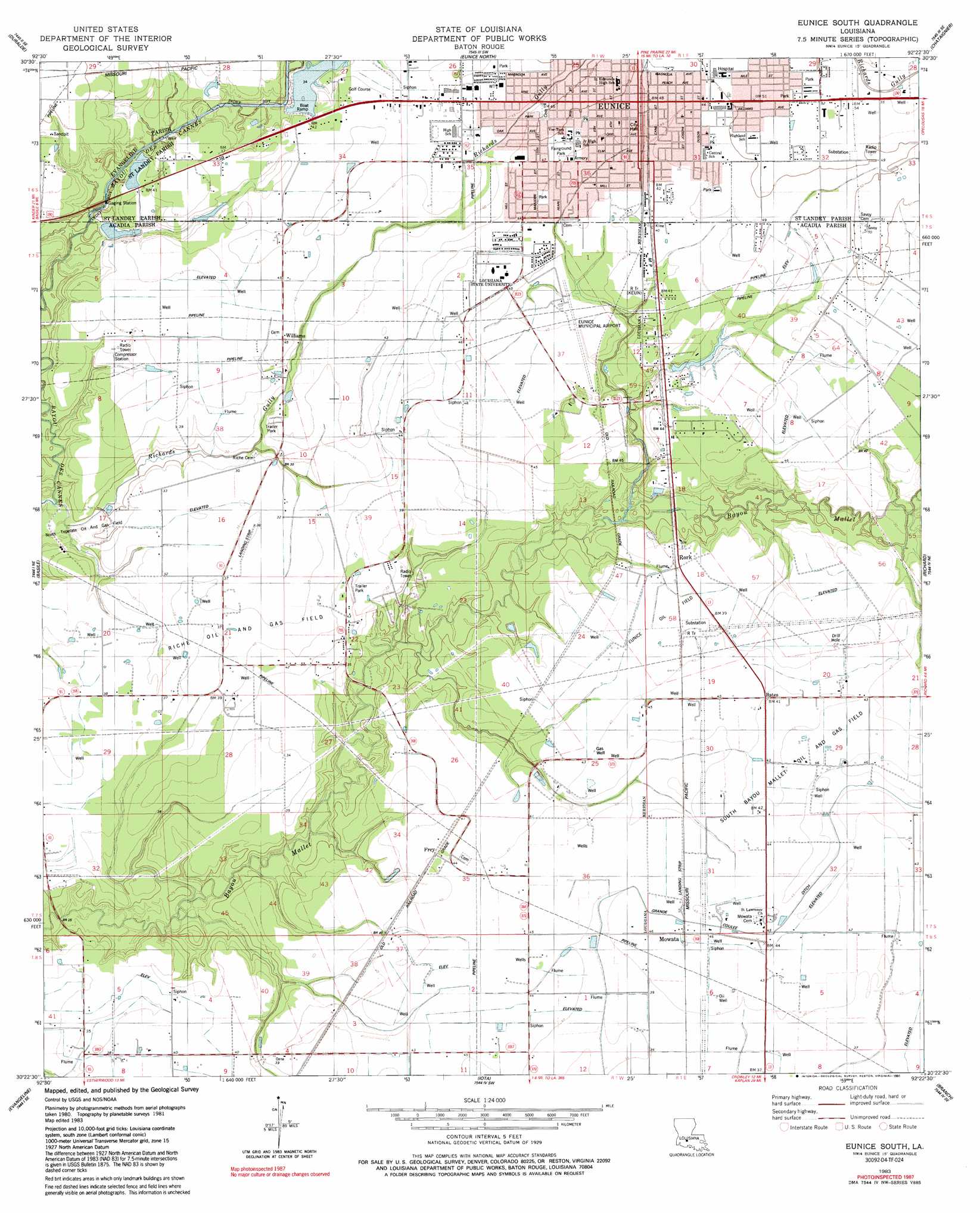
USGS Topo Quad 30092d4 - 1:24,000 scale
| Topo Map Name: | Eunice South |
| USGS Topo Quad ID: | 30092d4 |
| Print Size: | ca. 21 1/4" wide x 27" high |
| Southeast Coordinates: | 30.375° N latitude / 92.375° W longitude |
| Map Center Coordinates: | 30.4375° N latitude / 92.4375° W longitude |
| U.S. State: | LA |
| Filename: | o30092d4.jpg |
| Download Map JPG Image: | Eunice South topo map 1:24,000 scale |
| Map Type: | Topographic |
| Topo Series: | 7.5´ |
| Map Scale: | 1:24,000 |
| Source of Map Images: | United States Geological Survey (USGS) |
| Alternate Map Versions: |
Eunice South LA 1983, updated 1983 Download PDF Buy paper map Eunice South LA 1983, updated 1991 Download PDF Buy paper map Eunice South LA 2012 Download PDF Buy paper map Eunice South LA 2015 Download PDF Buy paper map |
1:24,000 Topo Quads surrounding Eunice South
Guy |
Bond |
Mamou |
Ville Platte |
Tate Cove |
Soileau |
Duralde |
Eunice North |
Chataignier |
Lawtell |
Elton |
Basile |
Eunice South |
Richard |
Church Point |
Hathaway |
Evangeline |
Iota |
Branch |
Mire |
Jennings |
Mermentau |
Crowley West |
Crowley East |
Duson |
> Back to 30092a1 at 1:100,000 scale
> Back to 30092a1 at 1:250,000 scale
> Back to U.S. Topo Maps home
Eunice South topo map: Gazetteer
Eunice South: Airports
Eunice Airport elevation 12m 39′L and L Sandblasting Heliport elevation 13m 42′
Moosa Memorial Hospital Heliport elevation 15m 49′
Eunice South: Areas
Prairie Faquetaique elevation 14m 45′Eunice South: Dams
City Park Lake Dam elevation 10m 32′Louisiana Noname 105 Dam elevation 11m 36′
Louisiana Noname 81 Dam elevation 9m 29′
Ruppert Lake Dam elevation 10m 32′
Eunice South: Oilfields
Eunice Oil Field elevation 12m 39′North Riche Oil and Gas Field elevation 8m 26′
Riche Oil and Gas Field elevation 11m 36′
Eunice South: Parks
Amy Addition Swimming Pool elevation 15m 49′Bobcat Field elevation 13m 42′
Fairground Park elevation 14m 45′
Saint Edmunds Athletic Field elevation 14m 45′
Eunice South: Populated Places
Bates elevation 12m 39′Eunice elevation 14m 45′
Frey elevation 12m 39′
Mowata elevation 13m 42′
Ritchie (historical) elevation 8m 26′
Rork elevation 11m 36′
Williams elevation 12m 39′
Eunice South: Post Offices
Eunice Post Office elevation 15m 49′Eunice South: Reservoirs
Ruppert Lake elevation 8m 26′Eunice South: Streams
Richards Gully elevation 7m 22′Tiger Point Gully elevation 8m 26′
Eunice South digital topo map on disk
Buy this Eunice South topo map showing relief, roads, GPS coordinates and other geographical features, as a high-resolution digital map file on DVD: