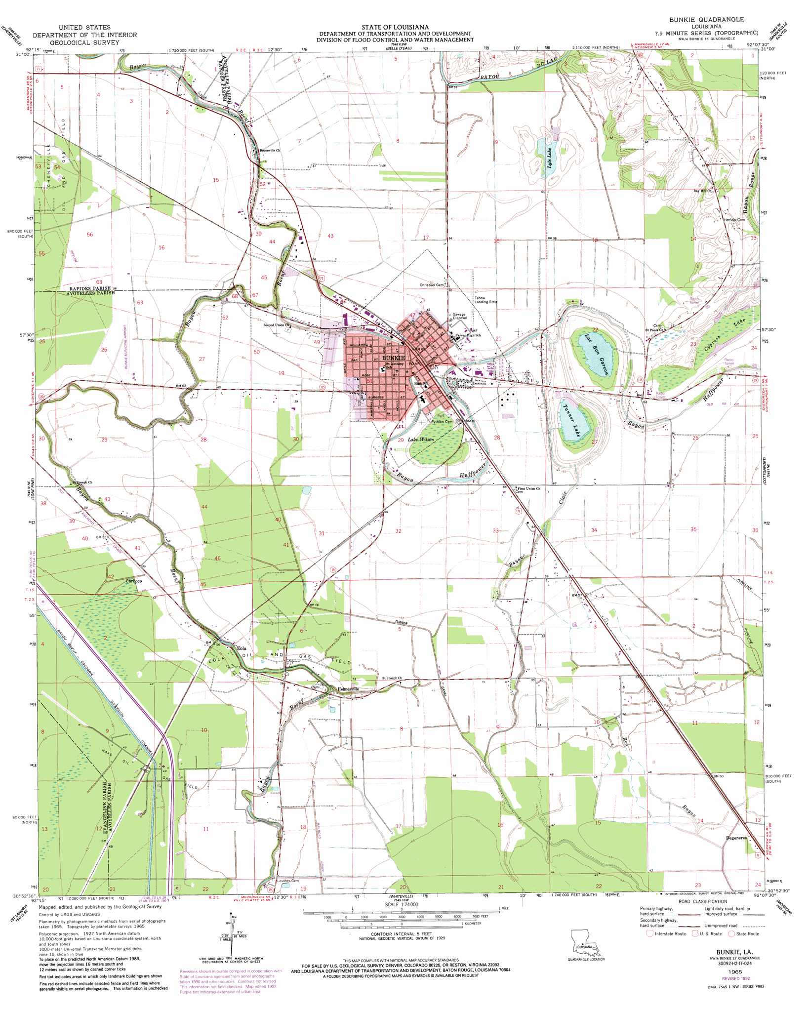
Bunkie Topo Map Louisiana
To zoom in, hover over the map of Bunkie
USGS Topo Quad 30092h2 - 1:24,000 scale
| Topo Map Name: | Bunkie |
| USGS Topo Quad ID: | 30092h2 |
| Print Size: | ca. 21 1/4" wide x 27" high |
| Southeast Coordinates: | 30.875° N latitude / 92.125° W longitude |
| Map Center Coordinates: | 30.9375° N latitude / 92.1875° W longitude |
| U.S. State: | LA |
| Filename: | o30092h2.jpg |
| Download Map JPG Image: | Bunkie topo map 1:24,000 scale |
| Map Type: | Topographic |
| Topo Series: | 7.5´ |
| Map Scale: | 1:24,000 |
| Source of Map Images: | United States Geological Survey (USGS) |
| Alternate Map Versions: |
Bunkie LA 1965, updated 1967 Download PDF Buy paper map Bunkie LA 1965, updated 1984 Download PDF Buy paper map Bunkie LA 1965, updated 1992 Download PDF Buy paper map Bunkie LA 2012 Download PDF Buy paper map Bunkie LA 2015 Download PDF Buy paper map |
1:24,000 Topo Quads surrounding Bunkie
Woodworth East |
Latanier |
Effie |
Marksville North |
Lac Sainte Agnes |
Lecompte |
Cheneyville |
Belle D'Eau |
Marksville South |
Moreauville |
Cocodrie Lake |
Lone Pine |
Bunkie |
Cottonport |
Plaucheville |
Pine Prairie |
Saint Landry |
Whiteville |
Morrow |
Bayou Jack |
Mamou |
Ville Platte |
Tate Cove |
Beggs |
Palmetto |
> Back to 30092e1 at 1:100,000 scale
> Back to 30092a1 at 1:250,000 scale
> Back to U.S. Topo Maps home
Bunkie topo map: Gazetteer
Bunkie: Airports
Bunkie Flying Service Airport elevation 18m 59′Bunkie Landing Strip elevation 18m 59′
Bunkie Municipal Airport elevation 18m 59′
Haas Landing Strip elevation 18m 59′
Mixon Airport elevation 18m 59′
Tebow Landing Strip elevation 18m 59′
Bunkie: Canals
Bayou Boeuf - Cocodrie Diversion Channel elevation 14m 45′Bayou Boeuf-Cocodrie Diversion Channel elevation 14m 45′
Turner Canal elevation 16m 52′
Bunkie: Dams
Lyle Lake Dam elevation 17m 55′Bunkie: Lakes
Cypress Lake elevation 17m 55′Lac Bon Garçon elevation 17m 55′
Lake Wilson elevation 18m 59′
Lyle Lake elevation 17m 55′
Tanner Lake elevation 17m 55′
Bunkie: Oilfields
Bayou Rouge Oil Field elevation 17m 55′Bunkie Oil Field elevation 17m 55′
Cheneyville Oil and Gas Field elevation 18m 59′
Eola Oil and Gas Field elevation 17m 55′
Haas Oil and Gas Field elevation 14m 45′
Bunkie: Populated Places
Bubenzer elevation 20m 65′Bunkie elevation 20m 65′
Carboco elevation 17m 55′
Degeneres elevation 13m 42′
Eola elevation 14m 45′
Friths (historical) elevation 20m 65′
Holmesville elevation 16m 52′
Kelley (historical) elevation 16m 52′
Leinster elevation 20m 65′
McDonald (historical) elevation 17m 55′
Nibot (historical) elevation 14m 45′
Shirley (historical) elevation 20m 65′
Star (historical) elevation 16m 52′
Bunkie: Post Offices
Bunkie Post Office elevation 20m 65′Bunkie: Streams
Bayou Clair elevation 15m 49′Bunkie digital topo map on disk
Buy this Bunkie topo map showing relief, roads, GPS coordinates and other geographical features, as a high-resolution digital map file on DVD: