Lone Pine Topo Map Louisiana
To zoom in, hover over the map of Lone Pine
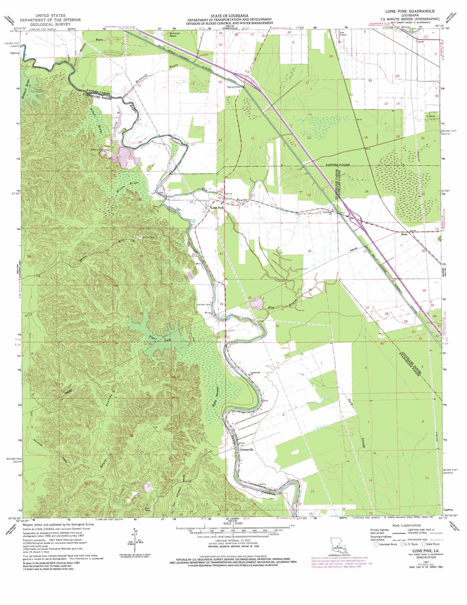
USGS Topo Quad 30092h3 - 1:24,000 scale
| Topo Map Name: | Lone Pine |
| USGS Topo Quad ID: | 30092h3 |
| Print Size: | ca. 21 1/4" wide x 27" high |
| Southeast Coordinates: | 30.875° N latitude / 92.25° W longitude |
| Map Center Coordinates: | 30.9375° N latitude / 92.3125° W longitude |
| U.S. State: | LA |
| Filename: | o30092h3.jpg |
| Download Map JPG Image: | Lone Pine topo map 1:24,000 scale |
| Map Type: | Topographic |
| Topo Series: | 7.5´ |
| Map Scale: | 1:24,000 |
| Source of Map Images: | United States Geological Survey (USGS) |
| Alternate Map Versions: |
Lone Pine LA 1967, updated 1968 Download PDF Buy paper map Lone Pine LA 1967, updated 1992 Download PDF Buy paper map Lone Pine LA 2012 Download PDF Buy paper map Lone Pine LA 2015 Download PDF Buy paper map |
1:24,000 Topo Quads surrounding Lone Pine
Woodworth West |
Woodworth East |
Latanier |
Effie |
Marksville North |
Forest Hill |
Lecompte |
Cheneyville |
Belle D'Eau |
Marksville South |
Glenmora |
Cocodrie Lake |
Lone Pine |
Bunkie |
Cottonport |
Beaver |
Pine Prairie |
Saint Landry |
Whiteville |
Morrow |
Bond |
Mamou |
Ville Platte |
Tate Cove |
Beggs |
> Back to 30092e1 at 1:100,000 scale
> Back to 30092a1 at 1:250,000 scale
> Back to U.S. Topo Maps home
Lone Pine topo map: Gazetteer
Lone Pine: Guts
McIntosh Bayou elevation 17m 55′Turtle Bayou elevation 16m 52′
Lone Pine: Lakes
Tiger Lake elevation 13m 42′Lone Pine: Populated Places
Centerville elevation 16m 52′Haas elevation 17m 55′
Lone Pine elevation 17m 55′
Stewart (historical) elevation 17m 55′
Lone Pine: Reservoirs
Townsend Lake (historical) elevation 15m 49′Lone Pine: Streams
Bayou Taureau elevation 14m 45′Elm Bayou elevation 15m 49′
McIntosh Bayou elevation 18m 59′
Morgans Bayou elevation 17m 55′
Lone Pine: Swamps
Robert Brake elevation 17m 55′Wilson Brake elevation 15m 49′
Lone Pine digital topo map on disk
Buy this Lone Pine topo map showing relief, roads, GPS coordinates and other geographical features, as a high-resolution digital map file on DVD: