Vinton Topo Map Louisiana
To zoom in, hover over the map of Vinton
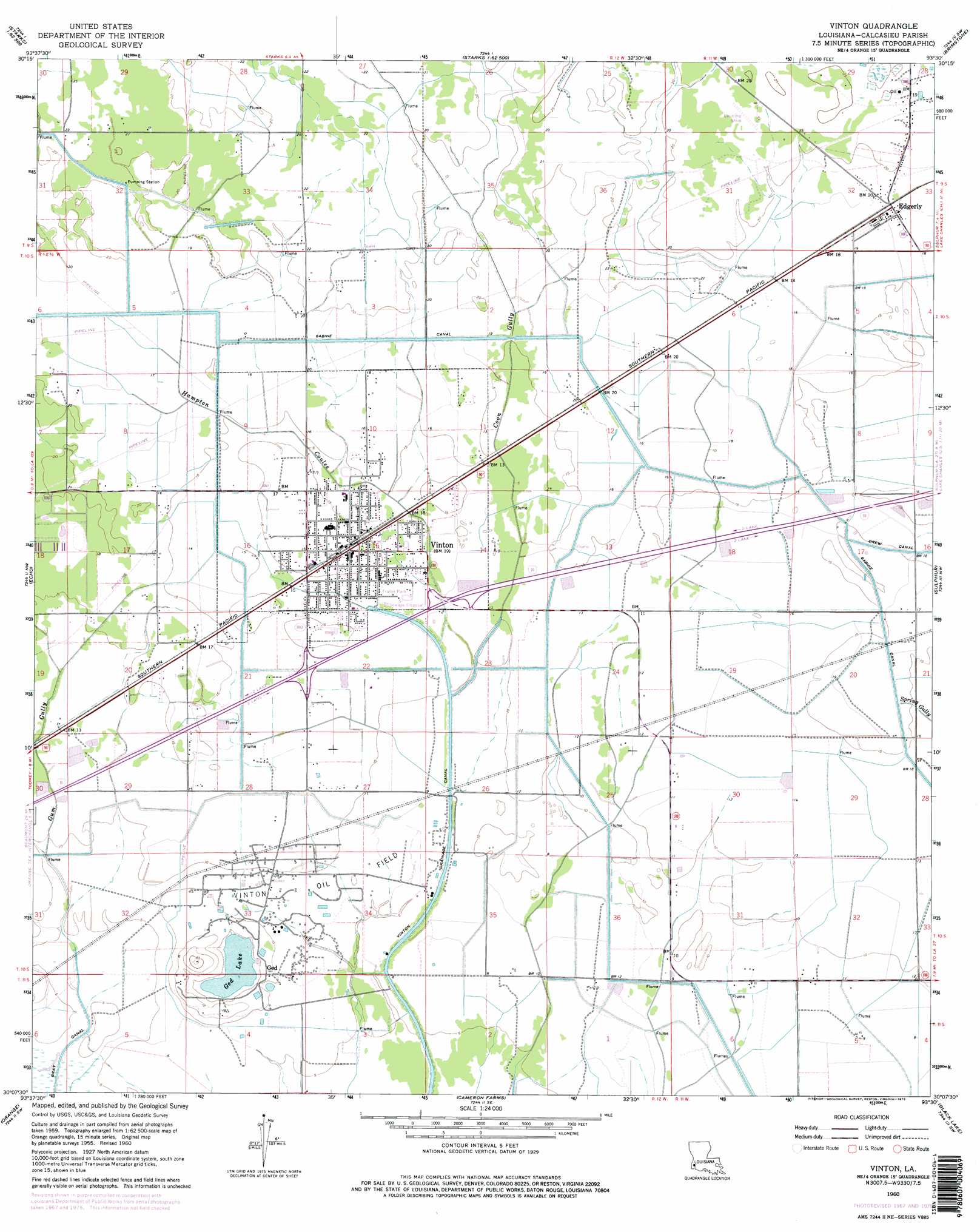
USGS Topo Quad 30093b5 - 1:24,000 scale
| Topo Map Name: | Vinton |
| USGS Topo Quad ID: | 30093b5 |
| Print Size: | ca. 21 1/4" wide x 27" high |
| Southeast Coordinates: | 30.125° N latitude / 93.5° W longitude |
| Map Center Coordinates: | 30.1875° N latitude / 93.5625° W longitude |
| U.S. State: | LA |
| Filename: | o30093b5.jpg |
| Download Map JPG Image: | Vinton topo map 1:24,000 scale |
| Map Type: | Topographic |
| Topo Series: | 7.5´ |
| Map Scale: | 1:24,000 |
| Source of Map Images: | United States Geological Survey (USGS) |
| Alternate Map Versions: |
Vinton LA 1960, updated 1961 Download PDF Buy paper map Vinton LA 1960, updated 1968 Download PDF Buy paper map Vinton LA 1960, updated 1976 Download PDF Buy paper map Vinton LA 1960, updated 1976 Download PDF Buy paper map Vinton LA 1994, updated 1996 Download PDF Buy paper map Vinton LA 2012 Download PDF Buy paper map Vinton LA 2015 Download PDF Buy paper map |
1:24,000 Topo Quads surrounding Vinton
Sudduth Bluff |
Shoats Creek |
Clark Hollow |
De Quincy |
Gordon |
Hartburg |
Starks |
Lunita |
Brimstone |
Buhler |
Mauriceville |
Echo |
Vinton |
Sulphur |
Westlake |
Orangefield |
Orange |
Cameron Farms |
Black Lake |
Moss Lake |
West Of Greens Bayou |
Greens Bayou |
Five Lakes |
Browns Lake |
Hackberry |
> Back to 30093a1 at 1:100,000 scale
> Back to 30092a1 at 1:250,000 scale
> Back to U.S. Topo Maps home
Vinton topo map: Gazetteer
Vinton: Areas
Sabine Prairie elevation 4m 13′Vinton: Canals
Sabine Canal elevation 5m 16′Vinton: Crossings
Interchange 7 elevation 5m 16′Interchange 8 elevation 5m 16′
Vinton: Lakes
Ged Lake elevation 2m 6′Vinton: Oilfields
Vinton Oil Field elevation 2m 6′Vinton: Populated Places
Edgerly elevation 6m 19′Ged elevation 4m 13′
Vinton elevation 5m 16′
Vinton: Post Offices
Ged Post Office elevation 4m 13′Vinton: Streams
Coon Gully elevation 6m 19′Gum Gully elevation 1m 3′
Hampton Coulee elevation 0m 0′
Vinton digital topo map on disk
Buy this Vinton topo map showing relief, roads, GPS coordinates and other geographical features, as a high-resolution digital map file on DVD: