Moss Bluff Topo Map Louisiana
To zoom in, hover over the map of Moss Bluff
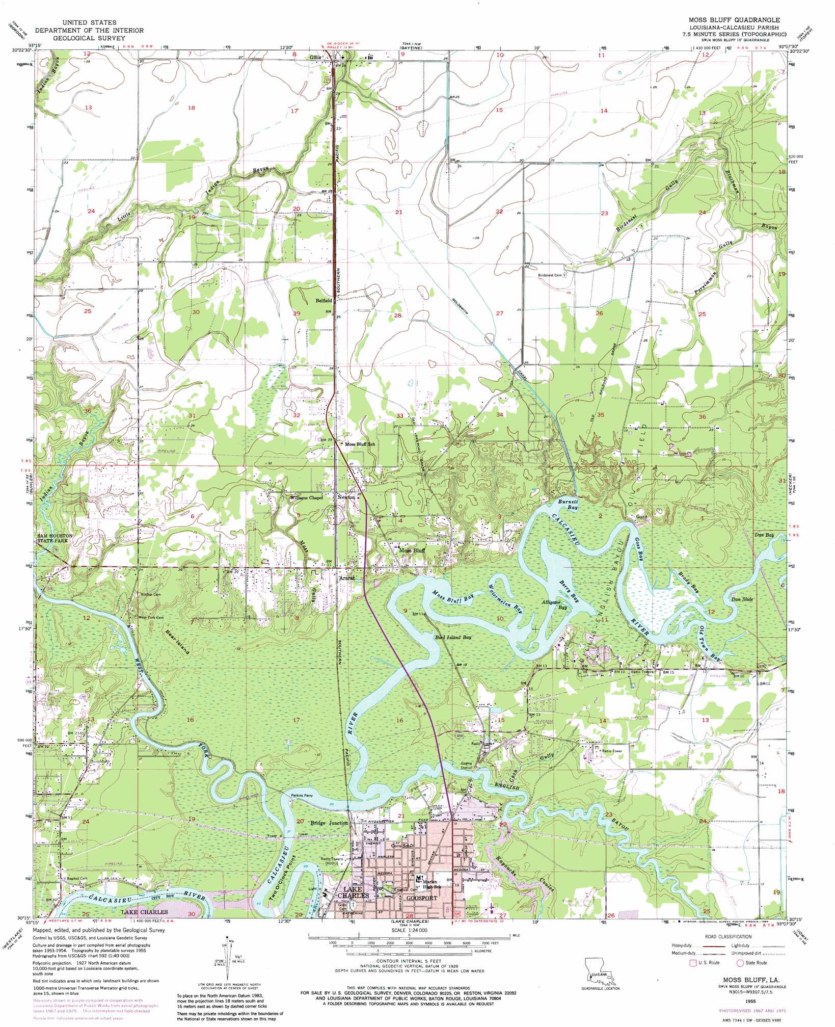
USGS Topo Quad 30093c2 - 1:24,000 scale
| Topo Map Name: | Moss Bluff |
| USGS Topo Quad ID: | 30093c2 |
| Print Size: | ca. 21 1/4" wide x 27" high |
| Southeast Coordinates: | 30.25° N latitude / 93.125° W longitude |
| Map Center Coordinates: | 30.3125° N latitude / 93.1875° W longitude |
| U.S. State: | LA |
| Filename: | o30093c2.jpg |
| Download Map JPG Image: | Moss Bluff topo map 1:24,000 scale |
| Map Type: | Topographic |
| Topo Series: | 7.5´ |
| Map Scale: | 1:24,000 |
| Source of Map Images: | United States Geological Survey (USGS) |
| Alternate Map Versions: |
Moss Bluff LA 1955, updated 1956 Download PDF Buy paper map Moss Bluff LA 1955, updated 1965 Download PDF Buy paper map Moss Bluff LA 1955, updated 1968 Download PDF Buy paper map Moss Bluff LA 1955, updated 1984 Download PDF Buy paper map Moss Bluff LA 1994, updated 1996 Download PDF Buy paper map Moss Bluff LA 2012 Download PDF Buy paper map Moss Bluff LA 2015 Download PDF Buy paper map |
1:24,000 Topo Quads surrounding Moss Bluff
Oretta |
Kernan |
Longville |
Reeves |
Le Blanc |
De Quincy |
Gordon |
Gaytine |
Topsy |
Indian Village |
Brimstone |
Buhler |
Moss Bluff |
Hecker |
Fenton |
Sulphur |
Westlake |
Lake Charles |
Iowa |
Lacassine |
Black Lake |
Moss Lake |
Lake Charles Sw |
Lake Charles Se |
Hayes |
> Back to 30093a1 at 1:100,000 scale
> Back to 30092a1 at 1:250,000 scale
> Back to U.S. Topo Maps home
Moss Bluff topo map: Gazetteer
Moss Bluff: Airports
Chloe Airport elevation 3m 9′Moss Bluff: Bays
Alligator Bay elevation 0m 0′Berry Bay elevation 0m 0′
Bird Island Bay elevation 0m 0′
Brady Bay elevation 0m 0′
Burnett Bay elevation 0m 0′
Dan Bay elevation 0m 0′
Dan Slide elevation 0m 0′
Goss Bay elevation 0m 0′
Moss Bluff Bay elevation 0m 0′
Old Town Bay elevation 0m 0′
Watermelon Bay elevation 0m 0′
Moss Bluff: Canals
Goldsmith Canal elevation 7m 22′Moss Bluff: Capes
Two O'Clock Point elevation 1m 3′Moss Bluff: Islands
Bear Island elevation 3m 9′Moss Bluff: Oilfields
Gillis-English Bayou Oil Field elevation 1m 3′Moss Bluff: Parks
Perkins Ferry Park elevation 1m 3′Moss Bluff: Populated Places
Ararat elevation 6m 19′Belfield elevation 8m 26′
Bridge Junction elevation 3m 9′
Gillis elevation 8m 26′
Goosport elevation 5m 16′
Goss elevation 6m 19′
Moss Bluff elevation 7m 22′
Newton elevation 8m 26′
Moss Bluff: Streams
Birdsnest Gully elevation 2m 6′Coon Gully elevation 0m 0′
English Bayou elevation 0m 0′
Kayouche Coulee elevation 0m 0′
Moss Gully elevation 1m 3′
Persimmon Gully elevation 2m 6′
West Fork Calcasieu River elevation 0m 0′
Moss Bluff digital topo map on disk
Buy this Moss Bluff topo map showing relief, roads, GPS coordinates and other geographical features, as a high-resolution digital map file on DVD: