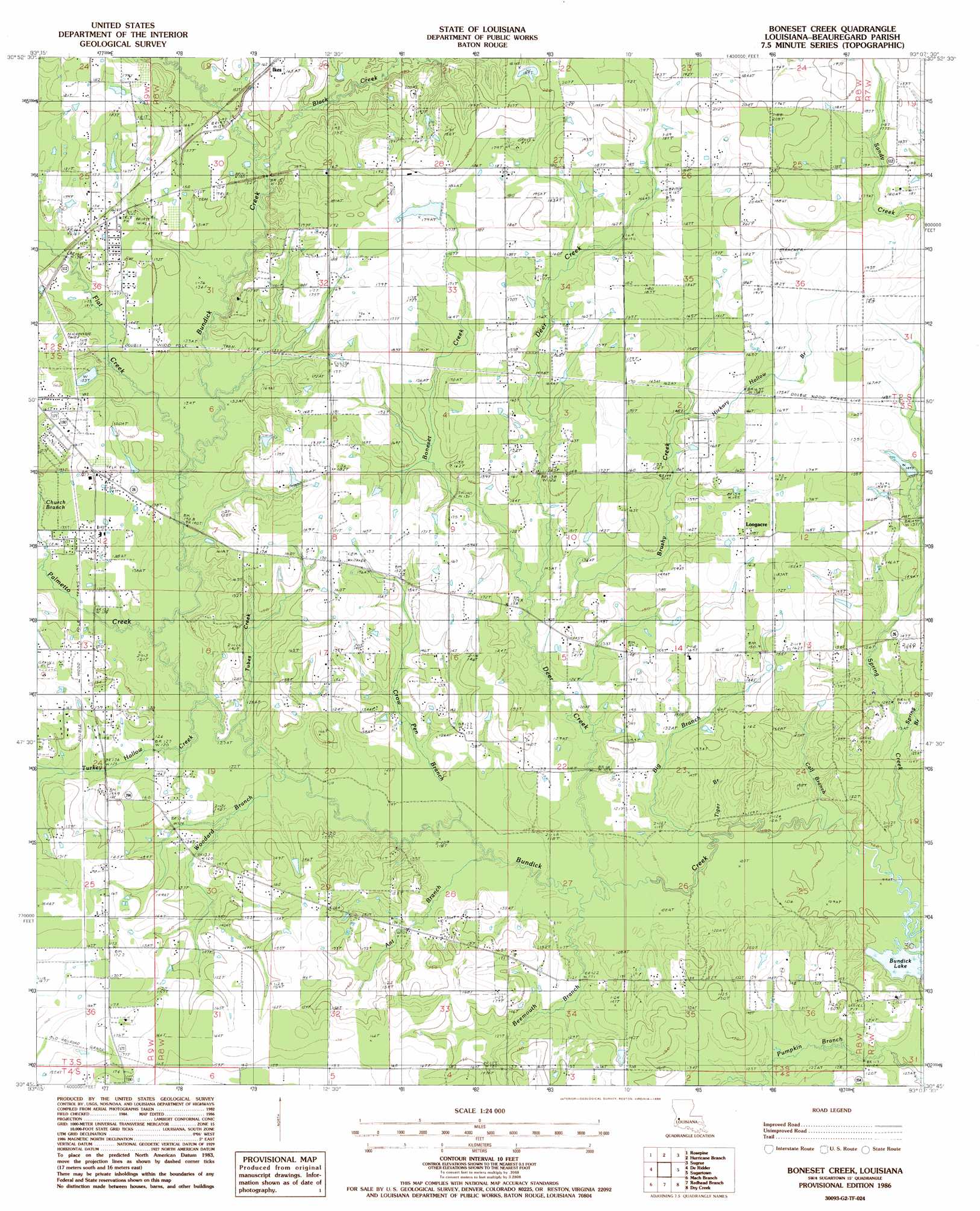
Boneset Creek Topo Map Louisiana
To zoom in, hover over the map of Boneset Creek
USGS Topo Quad 30093g2 - 1:24,000 scale
| Topo Map Name: | Boneset Creek |
| USGS Topo Quad ID: | 30093g2 |
| Print Size: | ca. 21 1/4" wide x 27" high |
| Southeast Coordinates: | 30.75° N latitude / 93.125° W longitude |
| Map Center Coordinates: | 30.8125° N latitude / 93.1875° W longitude |
| U.S. State: | LA |
| Filename: | o30093g2.jpg |
| Download Map JPG Image: | Boneset Creek topo map 1:24,000 scale |
| Map Type: | Topographic |
| Topo Series: | 7.5´ |
| Map Scale: | 1:24,000 |
| Source of Map Images: | United States Geological Survey (USGS) |
| Alternate Map Versions: |
Boneset Creek LA 1986, updated 1986 Download PDF Buy paper map Boneset Creek LA 1994, updated 1997 Download PDF Buy paper map Boneset Creek LA 2012 Download PDF Buy paper map Boneset Creek LA 2015 Download PDF Buy paper map |
1:24,000 Topo Quads surrounding Boneset Creek
Burr Ferry |
Newllano |
Fort Polk |
Birds Creek |
Fullerton Lake |
Knight |
Rose Pine |
Hurricane Branch |
Sugrue |
Pitkin |
Neale |
De Ridder |
Boneset Creek |
Sugartown |
Grant |
Singer |
Mach Branch |
Redhead Branch |
Dry Creek |
Mittie |
Oretta |
Kernan |
Longville |
Reeves |
Le Blanc |
> Back to 30093e1 at 1:100,000 scale
> Back to 30092a1 at 1:250,000 scale
> Back to U.S. Topo Maps home
Boneset Creek topo map: Gazetteer
Boneset Creek: Dams
Louisiana Noname 63 Dam elevation 50m 164′Louisiana Noname 64 Dam elevation 45m 147′
Boneset Creek: Populated Places
Ikes elevation 49m 160′Longacre elevation 54m 177′
Boneset Creek: Streams
Ant Branch elevation 32m 104′Beemouth Branch elevation 33m 108′
Big Branch elevation 32m 104′
Black Creek elevation 41m 134′
Boneset Creek elevation 37m 121′
Brushy Creek elevation 36m 118′
Calf Branch elevation 31m 101′
Church Branch elevation 39m 127′
Crow Pen Branch elevation 32m 104′
Deer Creek elevation 34m 111′
Flat Creek elevation 36m 118′
Hester Branch elevation 33m 108′
Hickory Hollow Branch elevation 48m 157′
Palmetto Creek elevation 36m 118′
Spring Branch elevation 33m 108′
Spring Creek elevation 40m 131′
Tiger Branch elevation 29m 95′
Tubes Creek elevation 37m 121′
Turkey Hollow Creek elevation 37m 121′
Woodard Branch elevation 36m 118′
Boneset Creek digital topo map on disk
Buy this Boneset Creek topo map showing relief, roads, GPS coordinates and other geographical features, as a high-resolution digital map file on DVD: