De Ridder Topo Map Louisiana
To zoom in, hover over the map of De Ridder
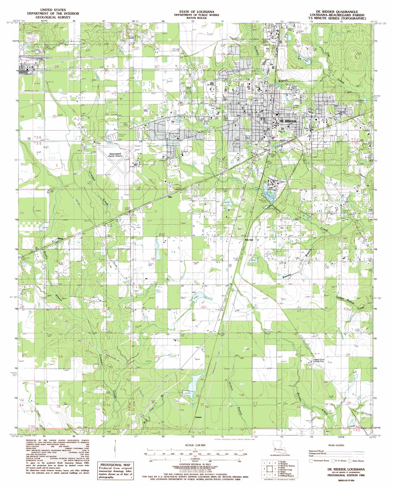
USGS Topo Quad 30093g3 - 1:24,000 scale
| Topo Map Name: | De Ridder |
| USGS Topo Quad ID: | 30093g3 |
| Print Size: | ca. 21 1/4" wide x 27" high |
| Southeast Coordinates: | 30.75° N latitude / 93.25° W longitude |
| Map Center Coordinates: | 30.8125° N latitude / 93.3125° W longitude |
| U.S. State: | LA |
| Filename: | o30093g3.jpg |
| Download Map JPG Image: | De Ridder topo map 1:24,000 scale |
| Map Type: | Topographic |
| Topo Series: | 7.5´ |
| Map Scale: | 1:24,000 |
| Source of Map Images: | United States Geological Survey (USGS) |
| Alternate Map Versions: |
Deridder LA 1984, updated 1997 Download PDF Buy paper map De Ridder LA 1986, updated 1986 Download PDF Buy paper map DeRidder LA 2012 Download PDF Buy paper map DeRidder LA 2015 Download PDF Buy paper map |
1:24,000 Topo Quads surrounding De Ridder
Wiergate Se |
Burr Ferry |
Newllano |
Fort Polk |
Birds Creek |
Evans |
Knight |
Rose Pine |
Hurricane Branch |
Sugrue |
Merryville North |
Neale |
De Ridder |
Boneset Creek |
Sugartown |
Merryville South |
Singer |
Mach Branch |
Redhead Branch |
Dry Creek |
Fields |
Oretta |
Kernan |
Longville |
Reeves |
> Back to 30093e1 at 1:100,000 scale
> Back to 30092a1 at 1:250,000 scale
> Back to U.S. Topo Maps home
De Ridder topo map: Gazetteer
De Ridder: Airports
Beauregard Parish Airport elevation 59m 193′Swamp Smith Airport elevation 53m 173′
De Ridder: Dams
Bon Ami Pond Dam elevation 53m 173′Litwillen Pond Dam elevation 55m 180′
Louisiana Noname 68 Dam elevation 60m 196′
Louisiana Noname 69 Dam elevation 49m 160′
Louisiana Noname 70 Dam elevation 53m 173′
Louisiana Noname 71 Dam elevation 55m 180′
Louisiana Noname 72 Dam elevation 54m 177′
De Ridder: Parks
Beauregard Parish Fairgrounds elevation 55m 180′Bryant Park elevation 51m 167′
DeRidder Commerical Historic District elevation 62m 203′
West Park elevation 53m 173′
De Ridder: Populated Places
Bon Ami elevation 57m 187′Carson elevation 53m 173′
DeRidder elevation 62m 203′
Grabow elevation 55m 180′
Hite elevation 59m 193′
Hudson Addition elevation 60m 196′
Ludington elevation 60m 196′
Shear elevation 56m 183′
De Ridder: Post Offices
DeRidder Post Office elevation 60m 196′De Ridder: Streams
Beetree Branch elevation 41m 134′Brushy Branch elevation 46m 150′
Hickory Branch elevation 47m 154′
De Ridder digital topo map on disk
Buy this De Ridder topo map showing relief, roads, GPS coordinates and other geographical features, as a high-resolution digital map file on DVD: