Beaumont East Topo Map Texas
To zoom in, hover over the map of Beaumont East
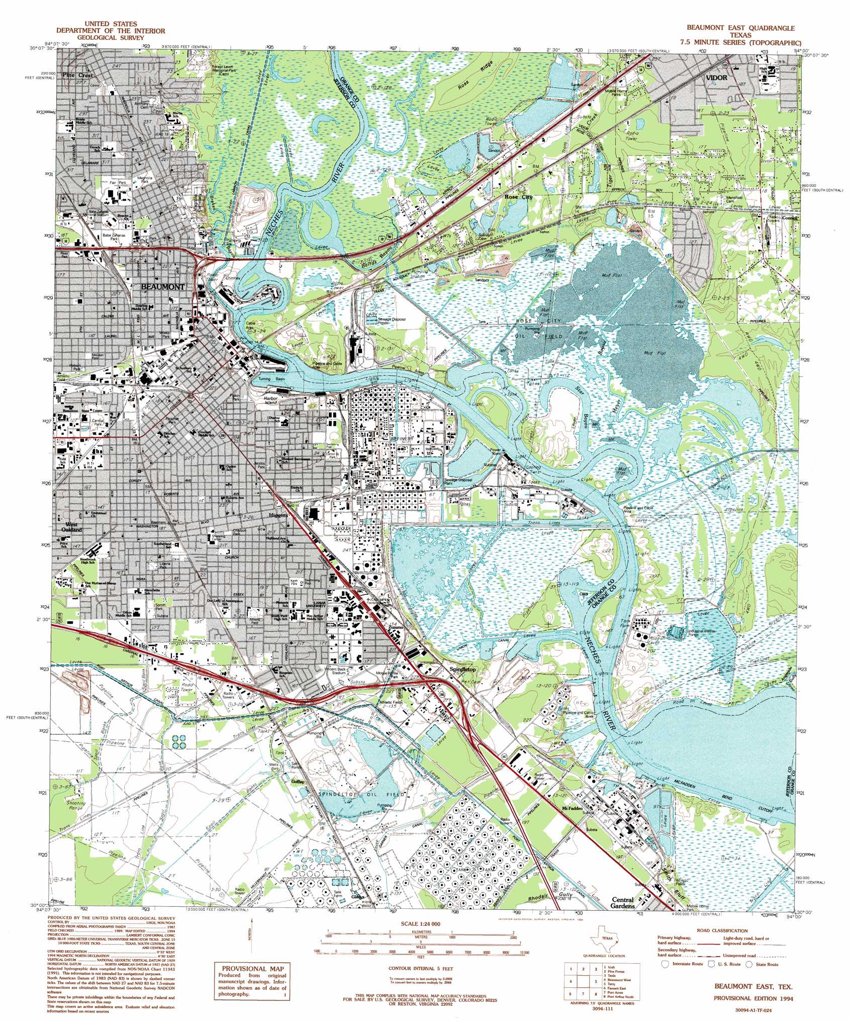
USGS Topo Quad 30094a1 - 1:24,000 scale
| Topo Map Name: | Beaumont East |
| USGS Topo Quad ID: | 30094a1 |
| Print Size: | ca. 21 1/4" wide x 27" high |
| Southeast Coordinates: | 30° N latitude / 94° W longitude |
| Map Center Coordinates: | 30.0625° N latitude / 94.0625° W longitude |
| U.S. State: | TX |
| Filename: | o30094a1.jpg |
| Download Map JPG Image: | Beaumont East topo map 1:24,000 scale |
| Map Type: | Topographic |
| Topo Series: | 7.5´ |
| Map Scale: | 1:24,000 |
| Source of Map Images: | United States Geological Survey (USGS) |
| Alternate Map Versions: |
Vidor TX 1926 Download PDF Buy paper map Beaumont East TX 1943, updated 1960 Download PDF Buy paper map Beaumont East TX 1960, updated 1962 Download PDF Buy paper map Beaumont East TX 1960, updated 1967 Download PDF Buy paper map Beaumont East TX 1960, updated 1971 Download PDF Buy paper map Beaumont East TX 1960, updated 1979 Download PDF Buy paper map Beaumont East TX 1960, updated 1979 Download PDF Buy paper map Beaumont East TX 1960, updated 1991 Download PDF Buy paper map Beaumont East TX 1994, updated 1994 Download PDF Buy paper map Beaumont East TX 2010 Download PDF Buy paper map Beaumont East TX 2013 Download PDF Buy paper map Beaumont East TX 2016 Download PDF Buy paper map |
1:24,000 Topo Quads surrounding Beaumont East
Kountze South |
Silsbee |
Evadale |
Gist |
Hartburg |
Bevil Oaks |
Voth |
Pine Forest |
Texla |
Mauriceville |
China |
Beaumont West |
Beaumont East |
Terry |
Orangefield |
Fannett West |
Fannett East |
Port Acres |
Port Arthur North |
West Of Greens Bayou |
Hamshire |
Alligator Hole Marsh |
Big Hill Bayou |
Port Arthur South |
West Of Johnsons Bayou |
> Back to 30094a1 at 1:100,000 scale
> Back to 30094a1 at 1:250,000 scale
> Back to U.S. Topo Maps home
Beaumont East topo map: Gazetteer
Beaumont East: Airports
Service Center Heliport elevation 5m 16′Beaumont East: Canals
Lawson Canal elevation 1m 3′Union Canal elevation 1m 3′
Beaumont East: Channels
McFadden Bend Cutoff elevation 0m 0′Beaumont East: Guts
Star Bayou elevation 0m 0′Beaumont East: Islands
Clark Island elevation 2m 6′Harbor Island elevation 5m 16′
Smith Island elevation 2m 6′
Beaumont East: Lakes
Twin Lakes elevation 2m 6′Beaumont East: Oilfields
Lucas Gusher Spindletop Oil Field elevation 6m 19′Rose City Oil Field elevation 1m 3′
Spindletop Oil Field elevation 5m 16′
Beaumont East: Parks
Babe Zaharias Memorial Stadium elevation 9m 29′Babe Zaharias Park elevation 8m 26′
Cardinal Stadium elevation 3m 9′
Carrol Street Park elevation 8m 26′
Central Park elevation 5m 16′
Chaison Park elevation 7m 22′
Cottonwood Park elevation 8m 26′
Fairpark Coliseum elevation 10m 32′
Fletcher Park elevation 6m 19′
Gladys City - Lucas Gusher Monument elevation 6m 19′
Hebert Park elevation 5m 16′
Jacobs Park elevation 7m 22′
Keith Park elevation 6m 19′
Liberia Park elevation 6m 19′
Magnolia Park elevation 8m 26′
McLean Park elevation 5m 16′
Montagne Center elevation 6m 19′
Pine Street Park elevation 3m 9′
Pipkin Park elevation 7m 22′
Reed Park elevation 7m 22′
Riverfront Park elevation 1m 3′
Roberts Park elevation 6m 19′
Spindletop Park elevation 5m 16′
Sprott Park elevation 5m 16′
Stuart Stadium (historical) elevation 7m 22′
Ty Terrell Track Stadium elevation 6m 19′
Vidor High School Football Stadium and Track elevation 5m 16′
Vincent Beck Stadium elevation 5m 16′
Wiess Park elevation 6m 19′
Beaumont East: Populated Places
Beaumont elevation 5m 16′Dowling elevation 6m 19′
Gladys elevation 6m 19′
Guffey elevation 5m 16′
Higgins elevation 8m 26′
McFadden elevation 6m 19′
Pine Crest elevation 8m 26′
Rose City elevation 3m 9′
Spindletop elevation 8m 26′
West Oakland elevation 4m 13′
Zummo elevation 6m 19′
Beaumont East: Ridges
Ross Ridge elevation 1m 3′Beaumont East: Springs
Spindletop Springs elevation 3m 9′Beaumont East: Streams
Meyer Bayou elevation 1m 3′Tiger Creek elevation 2m 6′
Beaumont East: Summits
Spindletop Hill elevation 4m 13′Beaumont East: Swamps
Bairds Bayou elevation 2m 6′Beaumont East: Trails
Babe Didrickson Zaharias Park Trail elevation 8m 26′Central Park Trail elevation 5m 16′
Sprott Park Trail elevation 5m 16′
Beaumont East: Valleys
Anderson Gully elevation 0m 0′Brakes Bayou elevation 0m 0′
Beaumont East digital topo map on disk
Buy this Beaumont East topo map showing relief, roads, GPS coordinates and other geographical features, as a high-resolution digital map file on DVD: