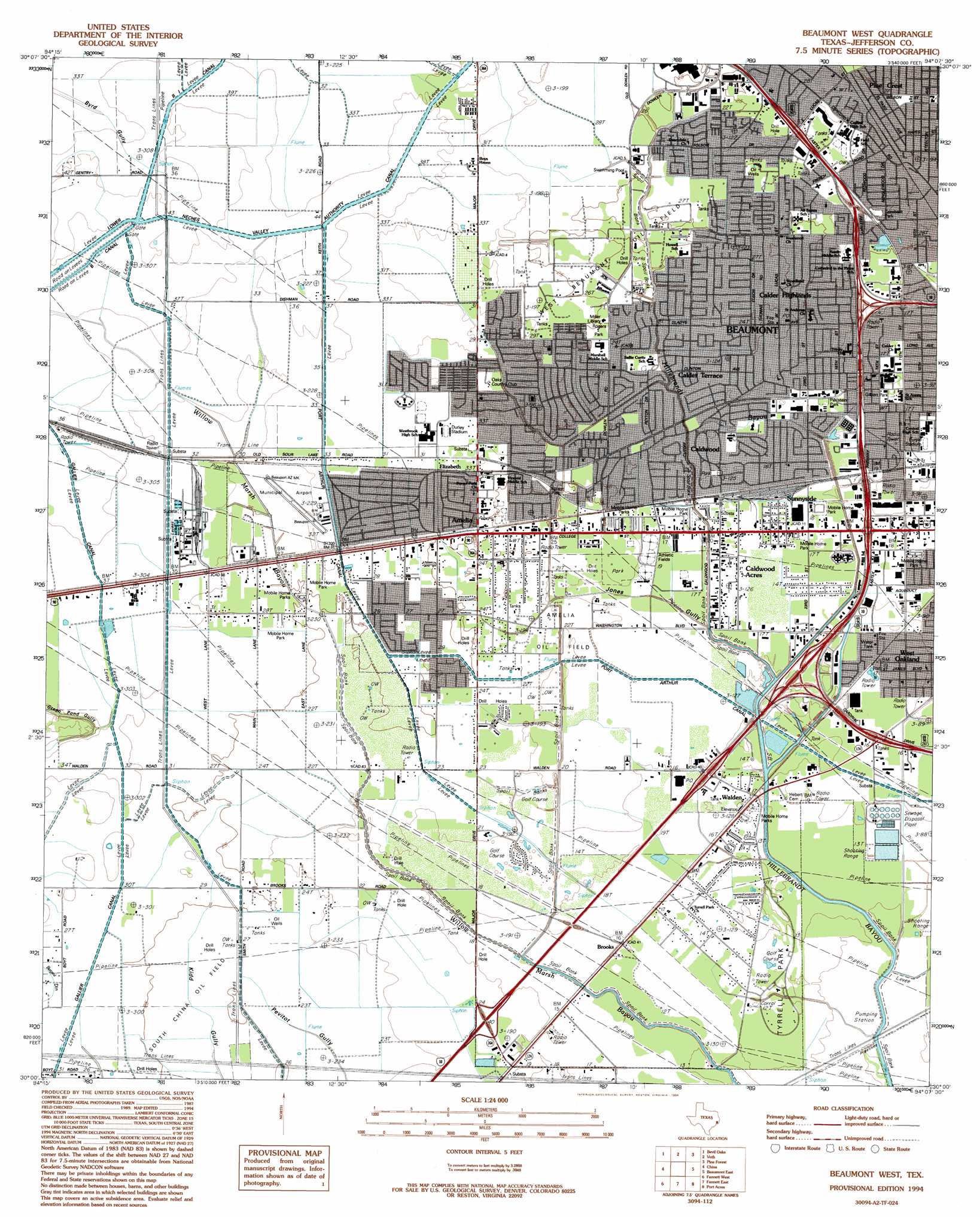
Beaumont West Topo Map Texas
To zoom in, hover over the map of Beaumont West
USGS Topo Quad 30094a2 - 1:24,000 scale
| Topo Map Name: | Beaumont West |
| USGS Topo Quad ID: | 30094a2 |
| Print Size: | ca. 21 1/4" wide x 27" high |
| Southeast Coordinates: | 30° N latitude / 94.125° W longitude |
| Map Center Coordinates: | 30.0625° N latitude / 94.1875° W longitude |
| U.S. State: | TX |
| Filename: | o30094a2.jpg |
| Download Map JPG Image: | Beaumont West topo map 1:24,000 scale |
| Map Type: | Topographic |
| Topo Series: | 7.5´ |
| Map Scale: | 1:24,000 |
| Source of Map Images: | United States Geological Survey (USGS) |
| Alternate Map Versions: |
Beaumont West TX 1960, updated 1962 Download PDF Buy paper map Beaumont West TX 1960, updated 1971 Download PDF Buy paper map Beaumont West TX 1960, updated 1979 Download PDF Buy paper map Beaumont West TX 1960, updated 1985 Download PDF Buy paper map Beaumont West TX 1994, updated 1994 Download PDF Buy paper map Beaumont West TX 2010 Download PDF Buy paper map Beaumont West TX 2013 Download PDF Buy paper map Beaumont West TX 2016 Download PDF Buy paper map |
1:24,000 Topo Quads surrounding Beaumont West
Kountze Sw |
Kountze South |
Silsbee |
Evadale |
Gist |
Sour Lake |
Bevil Oaks |
Voth |
Pine Forest |
Texla |
Nome |
China |
Beaumont West |
Beaumont East |
Terry |
Winnie Nw |
Fannett West |
Fannett East |
Port Acres |
Port Arthur North |
Stowell |
Hamshire |
Alligator Hole Marsh |
Big Hill Bayou |
Port Arthur South |
> Back to 30094a1 at 1:100,000 scale
> Back to 30094a1 at 1:250,000 scale
> Back to U.S. Topo Maps home
Beaumont West topo map: Gazetteer
Beaumont West: Airports
Baptist Hospital of Southeast Texas Heliport elevation 5m 16′Beaumont Municipal Airport elevation 9m 29′
KBMT-TV Heliport elevation 5m 16′
Sheraton Spindletop Hotel Heliport elevation 7m 22′
Beaumont West: Canals
B1 Canal elevation 12m 39′Caldwood Cutoff elevation 5m 16′
Gallier Canal elevation 8m 26′
Beaumont West: Oilfields
Amelia Oil Field elevation 7m 22′South China Oil Field elevation 7m 22′
West Beaumont Oil Field elevation 6m 19′
Beaumont West: Parks
Caldwood Park elevation 6m 19′Central Senior High School Baseball Field elevation 5m 16′
Central Senior High School Football Field elevation 5m 16′
Combest Park elevation 10m 32′
Durley Stadium elevation 10m 32′
Durley Stadium elevation 10m 32′
Forest Park elevation 8m 26′
Gilbert Park elevation 6m 19′
Municipal Athletic Complex elevation 7m 22′
Perlstein Park elevation 5m 16′
Purple Stadium elevation 5m 16′
Rogers Park elevation 8m 26′
Tyrrell Park elevation 4m 13′
Westbrook Senior High School Baseball Fields elevation 10m 32′
Wuthering Heights Park elevation 8m 26′
Beaumont West: Populated Places
Amelia elevation 9m 29′Calder Highlands elevation 8m 26′
Calder Terrace elevation 7m 22′
Caldwood elevation 5m 16′
Caldwood Acres elevation 5m 16′
Elizabeth elevation 9m 29′
Sunnyside elevation 5m 16′
Walden elevation 4m 13′
Beaumont West: Trails
Tyrell Park Trail elevation 4m 13′Beaumont West: Valleys
Jones Gully elevation 2m 6′Beaumont West digital topo map on disk
Buy this Beaumont West topo map showing relief, roads, GPS coordinates and other geographical features, as a high-resolution digital map file on DVD: