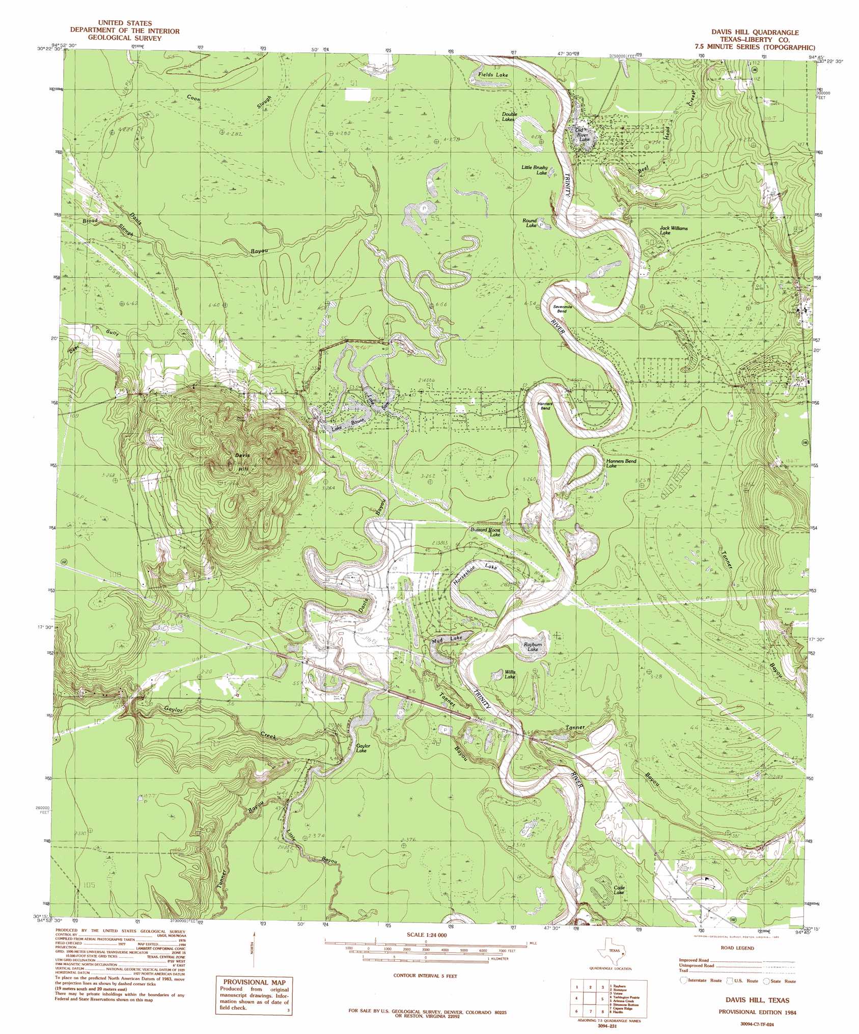
Davis Hill Topo Map Texas
To zoom in, hover over the map of Davis Hill
USGS Topo Quad 30094c7 - 1:24,000 scale
| Topo Map Name: | Davis Hill |
| USGS Topo Quad ID: | 30094c7 |
| Print Size: | ca. 21 1/4" wide x 27" high |
| Southeast Coordinates: | 30.25° N latitude / 94.75° W longitude |
| Map Center Coordinates: | 30.3125° N latitude / 94.8125° W longitude |
| U.S. State: | TX |
| Filename: | o30094c7.jpg |
| Download Map JPG Image: | Davis Hill topo map 1:24,000 scale |
| Map Type: | Topographic |
| Topo Series: | 7.5´ |
| Map Scale: | 1:24,000 |
| Source of Map Images: | United States Geological Survey (USGS) |
| Alternate Map Versions: |
Davis Hill TX 1984, updated 1985 Download PDF Buy paper map Davis Hill TX 2010 Download PDF Buy paper map Davis Hill TX 2013 Download PDF Buy paper map Davis Hill TX 2016 Download PDF Buy paper map |
1:24,000 Topo Quads surrounding Davis Hill
Camilla |
Goodrich |
Schwab City |
Segno |
Jacks Creek South |
Westcott |
Rayburn |
Romayor |
Votaw |
Bragg |
Cleveland |
Tarkington Prairie |
Davis Hill |
Arizona Creek |
Saratoga |
Plum Grove |
Simmons Bottom |
Capers Ridge |
Hardin |
Thorson Gully |
Huffman |
Dayton |
Liberty |
Daisetta |
Devers |
> Back to 30094a1 at 1:100,000 scale
> Back to 30094a1 at 1:250,000 scale
> Back to U.S. Topo Maps home
Davis Hill topo map: Gazetteer
Davis Hill: Bends
Hanners Bend elevation 15m 49′Sevenmile Bend elevation 10m 32′
Davis Hill: Cliffs
Tanners Bluff elevation 12m 39′Davis Hill: Dams
Cypress Lake Dam elevation 14m 45′Davis Hill: Lakes
Buzzard Roost Lake elevation 15m 49′Cade Lake elevation 14m 45′
Double Lakes elevation 16m 52′
Fields Lake elevation 17m 55′
Gaylor Lake elevation 14m 45′
Hanners Bend Lake elevation 13m 42′
Horseshoe Lake elevation 14m 45′
Jack Williams Lake elevation 16m 52′
Lake Bowie elevation 16m 52′
Lake Sam elevation 16m 52′
Little Brushy Lake elevation 13m 42′
Mud Lake elevation 13m 42′
Old River Lake elevation 17m 55′
Rayburn Lake elevation 11m 36′
Round Lake elevation 17m 55′
Willis Lake elevation 14m 45′
Davis Hill: Parks
Davis Hill State Park elevation 17m 55′Davis Hill: Populated Places
Coushatta Village elevation 14m 45′Franklin elevation 14m 45′
Grand Cane elevation 33m 108′
Jacob Settlement elevation 16m 52′
Sam Houston elevation 16m 52′
Trinity River Lake Estates elevation 15m 49′
Davis Hill: Reservoirs
Cypress Lake elevation 14m 45′Davis Hill: Streams
Beef Head Creek elevation 14m 45′Bledsoe Creek (historical) elevation 14m 45′
Board Slough elevation 15m 49′
Davis Bayou elevation 11m 36′
Gaylor Creek elevation 11m 36′
Davis Hill: Summits
Davis Hill elevation 74m 242′Davis Hill: Valleys
Deer Gully elevation 15m 49′Davis Hill digital topo map on disk
Buy this Davis Hill topo map showing relief, roads, GPS coordinates and other geographical features, as a high-resolution digital map file on DVD: