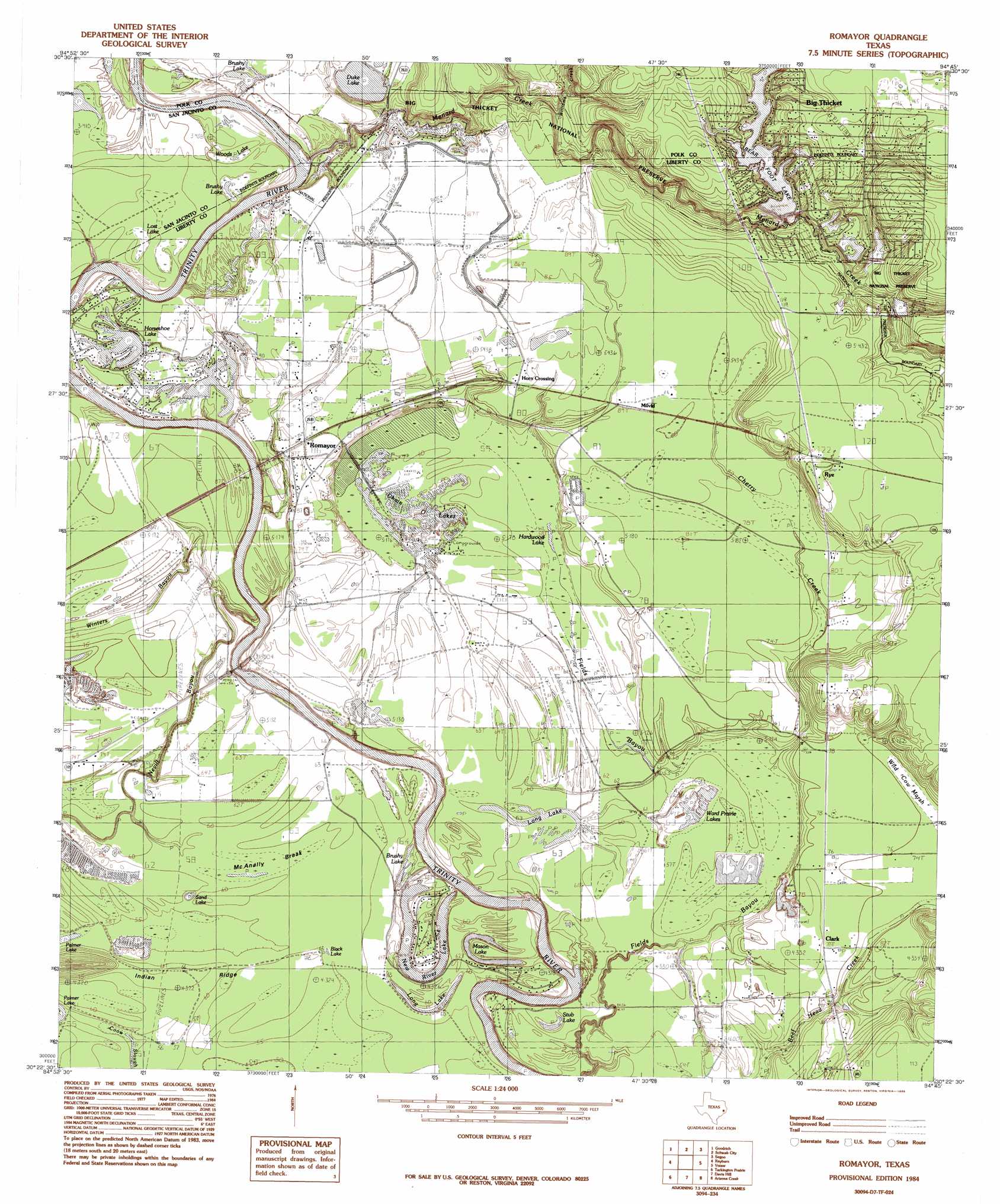
Romayor Topo Map Texas
To zoom in, hover over the map of Romayor
USGS Topo Quad 30094d7 - 1:24,000 scale
| Topo Map Name: | Romayor |
| USGS Topo Quad ID: | 30094d7 |
| Print Size: | ca. 21 1/4" wide x 27" high |
| Southeast Coordinates: | 30.375° N latitude / 94.75° W longitude |
| Map Center Coordinates: | 30.4375° N latitude / 94.8125° W longitude |
| U.S. State: | TX |
| Filename: | o30094d7.jpg |
| Download Map JPG Image: | Romayor topo map 1:24,000 scale |
| Map Type: | Topographic |
| Topo Series: | 7.5´ |
| Map Scale: | 1:24,000 |
| Source of Map Images: | United States Geological Survey (USGS) |
| Alternate Map Versions: |
Romayor TX 1984, updated 1985 Download PDF Buy paper map Romayor TX 2010 Download PDF Buy paper map Romayor TX 2013 Download PDF Buy paper map Romayor TX 2016 Download PDF Buy paper map |
1:24,000 Topo Quads surrounding Romayor
Blanchard |
Livingston |
Soda |
Dallardsville |
Jacks Creek North |
Camilla |
Goodrich |
Schwab City |
Segno |
Jacks Creek South |
Westcott |
Rayburn |
Romayor |
Votaw |
Bragg |
Cleveland |
Tarkington Prairie |
Davis Hill |
Arizona Creek |
Saratoga |
Plum Grove |
Simmons Bottom |
Capers Ridge |
Hardin |
Thorson Gully |
> Back to 30094a1 at 1:100,000 scale
> Back to 30094a1 at 1:250,000 scale
> Back to U.S. Topo Maps home
Romayor topo map: Gazetteer
Romayor: Airports
F R Duke Farm Airport elevation 26m 85′Romayor: Dams
6 Lakes Estates Lake Number 3 Dam elevation 22m 72′6 Lakes Estates Lake Number 4 Dam elevation 27m 88′
6 Lakes Estates Lake Number 5 Dam elevation 17m 55′
Bearfoot Lake Dam elevation 30m 98′
Duke Lake Dam elevation 22m 72′
Oneal Lake Dam elevation 19m 62′
Pond 1 Dam elevation 21m 68′
Romayor: Guts
Coon Slough elevation 17m 55′Romayor: Lakes
Black Lake elevation 17m 55′Brushy Lake elevation 18m 59′
Brushy Lake elevation 19m 62′
Brushy Lake elevation 21m 68′
Chain O'Lakes elevation 19m 62′
Hardwood Lake elevation 17m 55′
Horseshoe Lake elevation 19m 62′
Long Lake elevation 17m 55′
Lost Lake elevation 21m 68′
Mason Lake elevation 14m 45′
New River Lake elevation 14m 45′
Sand Lake elevation 17m 55′
Ward Prairie Lakes elevation 19m 62′
White Roselake elevation 17m 55′
Woods Lake elevation 19m 62′
Romayor: Populated Places
Big Creek elevation 20m 65′Big Thicket Creekmore Village elevation 34m 111′
Clark elevation 24m 78′
Marvels elevation 24m 78′
Mason Lake Estates elevation 18m 59′
Milvid elevation 26m 85′
Romayor elevation 26m 85′
Rye elevation 37m 121′
Romayor: Reservoirs
6 Lakes Estates Lake Number 5 elevation 17m 55′Bearfoot Lake elevation 30m 98′
Duke Lake elevation 23m 75′
Lake Number 3 elevation 22m 72′
Lake Number 4 elevation 27m 88′
Long Lake elevation 17m 55′
Oneal Lake elevation 19m 62′
Sand Lake elevation 16m 52′
Stub Lake elevation 18m 59′
Romayor: Ridges
Indian Ridge elevation 20m 65′Romayor: Springs
Williams Spring elevation 23m 75′Romayor: Streams
Big Thicket Menard Creek elevation 26m 85′Cherry Creek elevation 17m 55′
Fields Bayou elevation 17m 55′
Menard Creek elevation 19m 62′
Mill Creek elevation 26m 85′
Nevill Bayou elevation 13m 42′
Williams Creek elevation 21m 68′
Romayor: Swamps
McAnally Break elevation 18m 59′Romayor digital topo map on disk
Buy this Romayor topo map showing relief, roads, GPS coordinates and other geographical features, as a high-resolution digital map file on DVD: