Potato Patch Lake Topo Map Texas
To zoom in, hover over the map of Potato Patch Lake
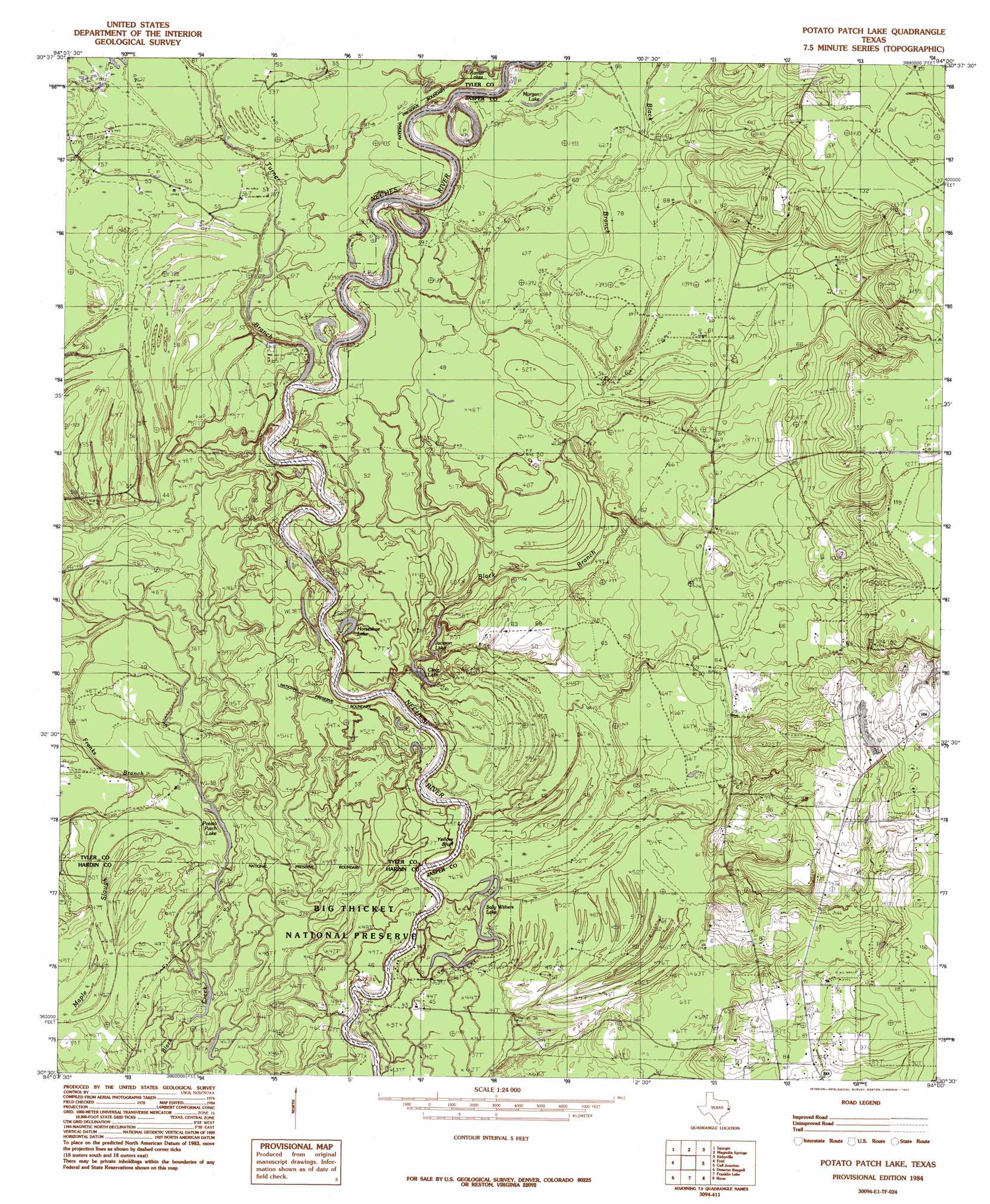
USGS Topo Quad 30094e1 - 1:24,000 scale
| Topo Map Name: | Potato Patch Lake |
| USGS Topo Quad ID: | 30094e1 |
| Print Size: | ca. 21 1/4" wide x 27" high |
| Southeast Coordinates: | 30.5° N latitude / 94° W longitude |
| Map Center Coordinates: | 30.5625° N latitude / 94.0625° W longitude |
| U.S. State: | TX |
| Filename: | o30094e1.jpg |
| Download Map JPG Image: | Potato Patch Lake topo map 1:24,000 scale |
| Map Type: | Topographic |
| Topo Series: | 7.5´ |
| Map Scale: | 1:24,000 |
| Source of Map Images: | United States Geological Survey (USGS) |
| Alternate Map Versions: |
Potato Patch Lake TX 1984, updated 1985 Download PDF Buy paper map Tater Patch Lake TX 2010 Download PDF Buy paper map Tater Patch Lake TX 2013 Download PDF Buy paper map Tater Patch Lake TX 2016 Download PDF Buy paper map |
1:24,000 Topo Quads surrounding Potato Patch Lake
Birdwell Lake |
Town Bluff |
Beech Grove |
Roganville |
Newton West |
Kirkpatrick Lake |
Spurger |
Magnolia Springs |
Kirbyville |
Bleakwood |
Hicksbaugh |
Fred |
Potato Patch Lake |
Call Junction |
Trout Creek |
Kountze North |
Deserter Baygall |
Franklin Lake |
Buna |
Sudduth Bluff |
Kountze South |
Silsbee |
Evadale |
Gist |
Hartburg |
> Back to 30094e1 at 1:100,000 scale
> Back to 30094a1 at 1:250,000 scale
> Back to U.S. Topo Maps home
Potato Patch Lake topo map: Gazetteer
Potato Patch Lake: Cliffs
Yellow Bluff elevation 14m 45′Potato Patch Lake: Guts
Maple Slough elevation 12m 39′Potato Patch Lake: Lakes
Briar Cane Break Lake elevation 11m 36′Clear Lake elevation 12m 39′
Horseshoe Lake elevation 12m 39′
Jackson Lake elevation 12m 39′
McGallion Lake elevation 12m 39′
Morgan Lake elevation 17m 55′
Sally Withers Lake elevation 12m 39′
Tater Patch Lake elevation 11m 36′
Potato Patch Lake: Oilfields
Sally Withers Lake Oil Field elevation 28m 91′Potato Patch Lake: Streams
Black Branch elevation 13m 42′Franks Branch elevation 12m 39′
Mill Creek elevation 13m 42′
Turner Branch elevation 12m 39′
Potato Patch Lake digital topo map on disk
Buy this Potato Patch Lake topo map showing relief, roads, GPS coordinates and other geographical features, as a high-resolution digital map file on DVD: