Birdwell Lake Topo Map Texas
To zoom in, hover over the map of Birdwell Lake
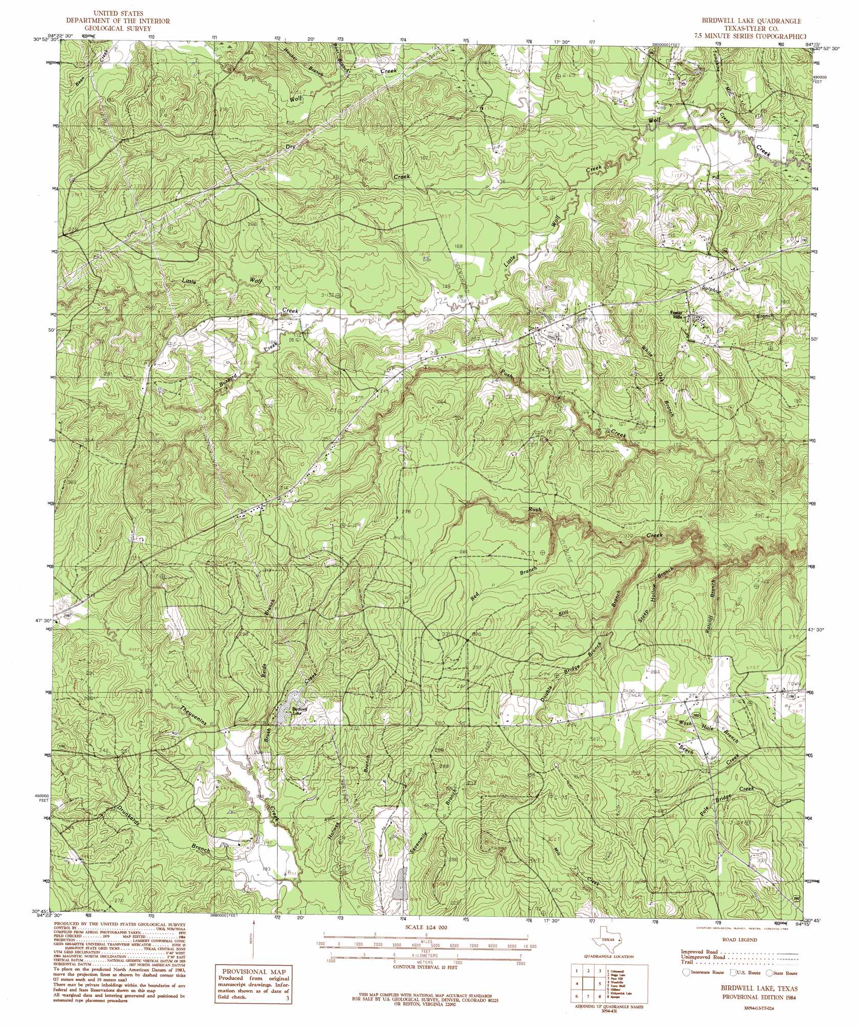
USGS Topo Quad 30094g3 - 1:24,000 scale
| Topo Map Name: | Birdwell Lake |
| USGS Topo Quad ID: | 30094g3 |
| Print Size: | ca. 21 1/4" wide x 27" high |
| Southeast Coordinates: | 30.75° N latitude / 94.25° W longitude |
| Map Center Coordinates: | 30.8125° N latitude / 94.3125° W longitude |
| U.S. State: | TX |
| Filename: | o30094g3.jpg |
| Download Map JPG Image: | Birdwell Lake topo map 1:24,000 scale |
| Map Type: | Topographic |
| Topo Series: | 7.5´ |
| Map Scale: | 1:24,000 |
| Source of Map Images: | United States Geological Survey (USGS) |
| Alternate Map Versions: |
Birdwell Lake TX 2010 Download PDF Buy paper map Birdwell Lake TX 2013 Download PDF Buy paper map Birdwell Lake TX 2016 Download PDF Buy paper map |
1:24,000 Topo Quads surrounding Birdwell Lake
Wolf Hill |
Rockland |
Boykin Spring |
Ebenezer |
Mcgee Bend |
Chester |
Colmesneil |
Boggy Lake |
Pace Hill |
Jasper West |
Chambliss Hill |
Woodville |
Birdwell Lake |
Town Bluff |
Beech Grove |
Jacks Creek North |
Hillister |
Kirkpatrick Lake |
Spurger |
Magnolia Springs |
Jacks Creek South |
Warren |
Hicksbaugh |
Fred |
Potato Patch Lake |
> Back to 30094e1 at 1:100,000 scale
> Back to 30094a1 at 1:250,000 scale
> Back to U.S. Topo Maps home
Birdwell Lake topo map: Gazetteer
Birdwell Lake: Dams
Allison Lake Dam elevation 61m 200′Birdwell Lake Dam elevation 71m 232′
Birdwell Lake: Lakes
Birdwell Lake elevation 70m 229′Birdwell Lake: Populated Places
Emille elevation 62m 203′Birdwell Lake: Reservoirs
Allison Lake elevation 61m 200′Birdwell Lake elevation 71m 232′
Birdwell Lake: Streams
Boar Branch elevation 43m 141′Brush Creek elevation 61m 200′
Buzzard Creek elevation 49m 160′
Clear Fork Creek elevation 40m 131′
Double Bridge Branch elevation 60m 196′
Drunkards Branch elevation 58m 190′
Dry Creek elevation 37m 121′
Hooker Branch elevation 43m 141′
Little Wolf Creek elevation 27m 88′
Ratcliff Branch elevation 47m 154′
Red Branch elevation 55m 180′
Reids Branch elevation 62m 203′
Steep Hollow Branch elevation 47m 154′
Still Branch elevation 48m 157′
Tompkins Mill Creek elevation 29m 95′
Wash Hole Branch elevation 68m 223′
White Oak Branch elevation 40m 131′
Birdwell Lake: Trails
Dogwood Trail elevation 96m 314′Birdwell Lake digital topo map on disk
Buy this Birdwell Lake topo map showing relief, roads, GPS coordinates and other geographical features, as a high-resolution digital map file on DVD: