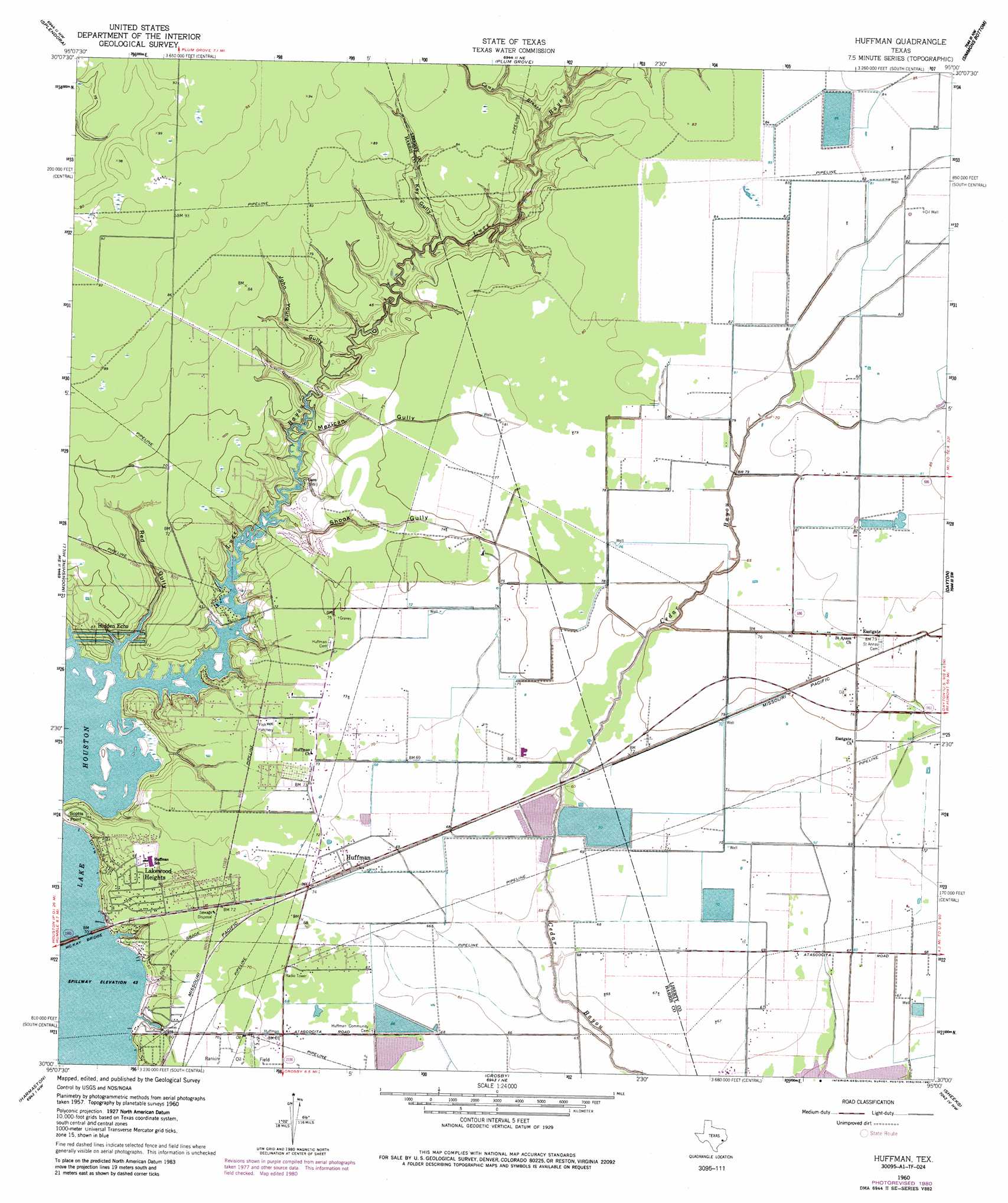
Huffman Topo Map Texas
To zoom in, hover over the map of Huffman
USGS Topo Quad 30095a1 - 1:24,000 scale
| Topo Map Name: | Huffman |
| USGS Topo Quad ID: | 30095a1 |
| Print Size: | ca. 21 1/4" wide x 27" high |
| Southeast Coordinates: | 30° N latitude / 95° W longitude |
| Map Center Coordinates: | 30.0625° N latitude / 95.0625° W longitude |
| U.S. State: | TX |
| Filename: | o30095a1.jpg |
| Download Map JPG Image: | Huffman topo map 1:24,000 scale |
| Map Type: | Topographic |
| Topo Series: | 7.5´ |
| Map Scale: | 1:24,000 |
| Source of Map Images: | United States Geological Survey (USGS) |
| Alternate Map Versions: |
Huffman TX 1916 Download PDF Buy paper map Huffman TX 1916 Download PDF Buy paper map Huffman TX 1916 Download PDF Buy paper map Huffman TX 1960, updated 1962 Download PDF Buy paper map Huffman TX 1960, updated 1975 Download PDF Buy paper map Huffman TX 1960, updated 1980 Download PDF Buy paper map Huffman TX 1960, updated 1987 Download PDF Buy paper map Huffman TX 2010 Download PDF Buy paper map Huffman TX 2013 Download PDF Buy paper map Huffman TX 2016 Download PDF Buy paper map |
1:24,000 Topo Quads surrounding Huffman
Cut And Shoot |
Fostoria |
Cleveland |
Tarkington Prairie |
Davis Hill |
Outlaw Pond |
Splendora |
Plum Grove |
Simmons Bottom |
Capers Ridge |
Maedan |
Moonshine Hill |
Huffman |
Dayton |
Liberty |
Humble |
Harmaston |
Crosby |
Sheeks |
Moss Bluff |
Settegast |
Jacinto City |
Highlands |
Mont Belvieu |
Cove |
> Back to 30095a1 at 1:100,000 scale
> Back to 30094a1 at 1:250,000 scale
> Back to U.S. Topo Maps home
Huffman topo map: Gazetteer
Huffman: Capes
Scotts Point elevation 17m 55′Huffman: Dams
Seaberg Reservoir Number 1 Levee elevation 20m 65′Seaberg Reservoir Number 2 Levee elevation 20m 65′
Seaberg Reservoir Number 3 Dam elevation 21m 68′
Seaberg Reservoir Number 4 Dam elevation 21m 68′
Huffman: Parks
L T May Park elevation 23m 75′Huffman: Populated Places
Eastgate elevation 24m 78′Hidden Echo elevation 13m 42′
Huffman elevation 21m 68′
Huffman Oaks elevation 21m 68′
Lakeside Manor elevation 20m 65′
Lakewood Heights elevation 20m 65′
Shorewood elevation 19m 62′
Huffman: Reservoirs
Seaberg Reservoir Number 1 elevation 20m 65′Seaberg Reservoir Number 2 elevation 20m 65′
Seaberg Reservoir Number 3 elevation 21m 68′
Seaberg Reservoir Number 4 elevation 21m 68′
Huffman: Streams
Camp Branch elevation 16m 52′Luce Bayou elevation 13m 42′
Huffman: Valleys
John Young Gully elevation 14m 45′Key Gully elevation 15m 49′
Mexican Gully elevation 14m 45′
Red Gully elevation 13m 42′
Shook Gully elevation 13m 42′
Huffman digital topo map on disk
Buy this Huffman topo map showing relief, roads, GPS coordinates and other geographical features, as a high-resolution digital map file on DVD: