Spring Topo Map Texas
To zoom in, hover over the map of Spring
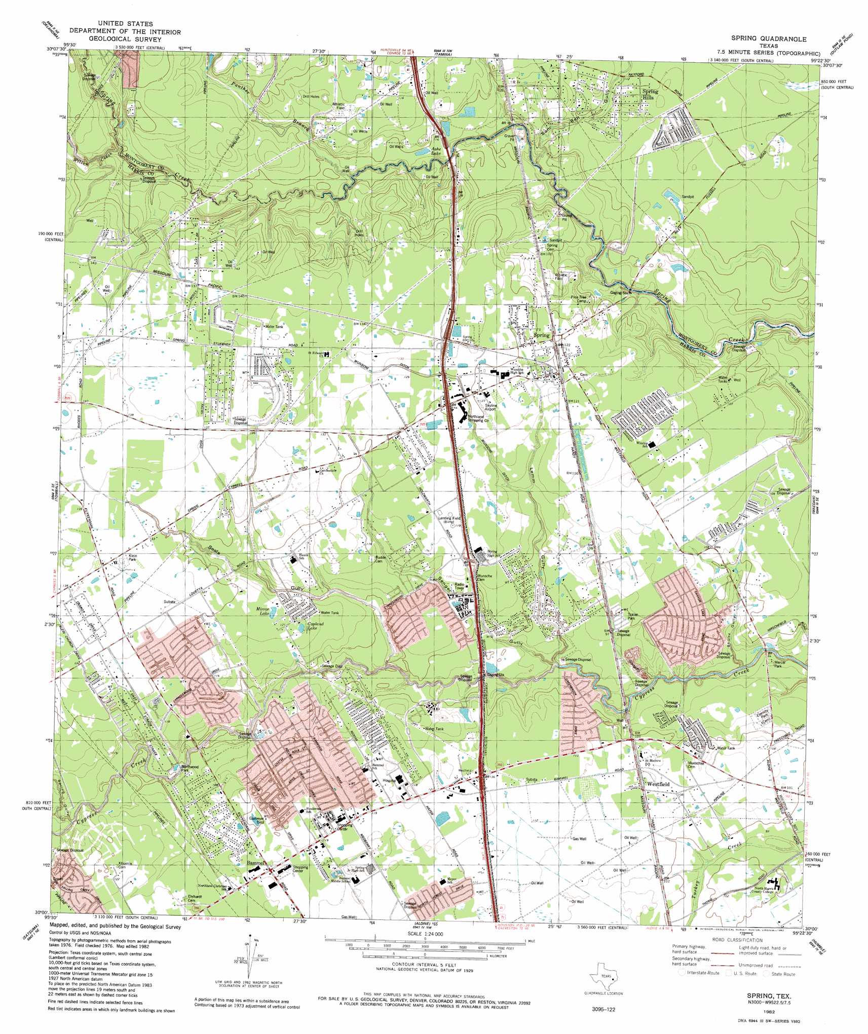
USGS Topo Quad 30095a4 - 1:24,000 scale
| Topo Map Name: | Spring |
| USGS Topo Quad ID: | 30095a4 |
| Print Size: | ca. 21 1/4" wide x 27" high |
| Southeast Coordinates: | 30° N latitude / 95.375° W longitude |
| Map Center Coordinates: | 30.0625° N latitude / 95.4375° W longitude |
| U.S. State: | TX |
| Filename: | o30095a4.jpg |
| Download Map JPG Image: | Spring topo map 1:24,000 scale |
| Map Type: | Topographic |
| Topo Series: | 7.5´ |
| Map Scale: | 1:24,000 |
| Source of Map Images: | United States Geological Survey (USGS) |
| Alternate Map Versions: |
Spring TX 1916 Download PDF Buy paper map Spring TX 1916 Download PDF Buy paper map Spring TX 1916, updated 1958 Download PDF Buy paper map Spring TX 1960, updated 1962 Download PDF Buy paper map Spring TX 1960, updated 1973 Download PDF Buy paper map Spring TX 1982, updated 1982 Download PDF Buy paper map Spring TX 1995, updated 2000 Download PDF Buy paper map Spring TX 2010 Download PDF Buy paper map Spring TX 2013 Download PDF Buy paper map Spring TX 2016 Download PDF Buy paper map |
1:24,000 Topo Quads surrounding Spring
Keenan |
Cowl Spur |
Conroe |
Cut And Shoot |
Fostoria |
Magnolia East |
Oklahoma |
Tamina |
Outlaw Pond |
Splendora |
Rose Hill |
Tomball |
Spring |
Maedan |
Moonshine Hill |
Cypress |
Satsuma |
Aldine |
Humble |
Harmaston |
Addicks |
Hedwig Village |
Houston Heights |
Settegast |
Jacinto City |
> Back to 30095a1 at 1:100,000 scale
> Back to 30094a1 at 1:250,000 scale
> Back to U.S. Topo Maps home
Spring topo map: Gazetteer
Spring: Airports
Goodyear Airship Operations Airport elevation 35m 114′Houston Northwest Medical Center Heliport elevation 37m 121′
Spring: Canals
Wunsche Ditch elevation 36m 118′Spring: Crossings
Interchange 68 elevation 41m 134′Interchange 70A elevation 42m 137′
Spring: Lakes
Ashe Lake elevation 30m 98′Copeland Lake elevation 37m 121′
Mirror Lake elevation 37m 121′
Spring: Oilfields
Bender Oil Field elevation 35m 114′Kuhlman Oil Field elevation 40m 131′
Rotherwood Oil Field elevation 43m 141′
Spring: Parks
Bayer Park elevation 34m 111′Enchanted Oaks Park elevation 30m 98′
Goodyear Blimp Park elevation 36m 118′
Kiein Park elevation 41m 134′
Mercer Paril Park elevation 25m 82′
Northwood Park elevation 30m 98′
Spring Klein Park elevation 43m 141′
Spring Stadium elevation 35m 114′
Westfield High School Baseball Field elevation 35m 114′
Westfield High School Football Stadium and Track elevation 35m 114′
Westfield High School Softball Field elevation 35m 114′
Spring: Populated Places
Bammel elevation 37m 121′Bammel Forest elevation 31m 101′
Bammel Timbers elevation 37m 121′
Bridgestone Ranch elevation 41m 134′
Candlelight Hills elevation 34m 111′
Chantilly Woods elevation 32m 104′
Cypress Villas elevation 35m 114′
Cypresswood elevation 33m 108′
Cypresswood Court elevation 35m 114′
Cypresswood Glen elevation 38m 124′
Forest North elevation 43m 141′
Fox Hollow elevation 43m 141′
Lexington Woods elevation 37m 121′
North Forest elevation 34m 111′
Northgate Crossing elevation 39m 127′
Northland Shopping Center elevation 29m 95′
Northridge Park elevation 33m 108′
Northview elevation 34m 111′
Oak Creek Village elevation 35m 114′
Oaks of Devonshire elevation 35m 114′
Olde Oaks elevation 37m 121′
Ponderosa Forest elevation 32m 104′
Rotherwood elevation 43m 141′
Spring elevation 37m 121′
Spring Hills elevation 34m 111′
Spring Lakes elevation 35m 114′
Terranova elevation 37m 121′
Timber Lane elevation 33m 108′
Westfield elevation 34m 111′
Windsor Forest elevation 41m 134′
Spring: Streams
Panther Branch elevation 25m 82′Willow Creek elevation 29m 95′
Spring: Trails
Mercer Arboretum and Botanic Gardens Trail elevation 25m 82′Spring: Valleys
Lemm Gully elevation 21m 68′Sam Bell Gully elevation 23m 75′
Schultz Gully elevation 18m 59′
Seals Gully elevation 25m 82′
Senger Gully elevation 25m 82′
Spring Gully elevation 31m 101′
Spring digital topo map on disk
Buy this Spring topo map showing relief, roads, GPS coordinates and other geographical features, as a high-resolution digital map file on DVD: