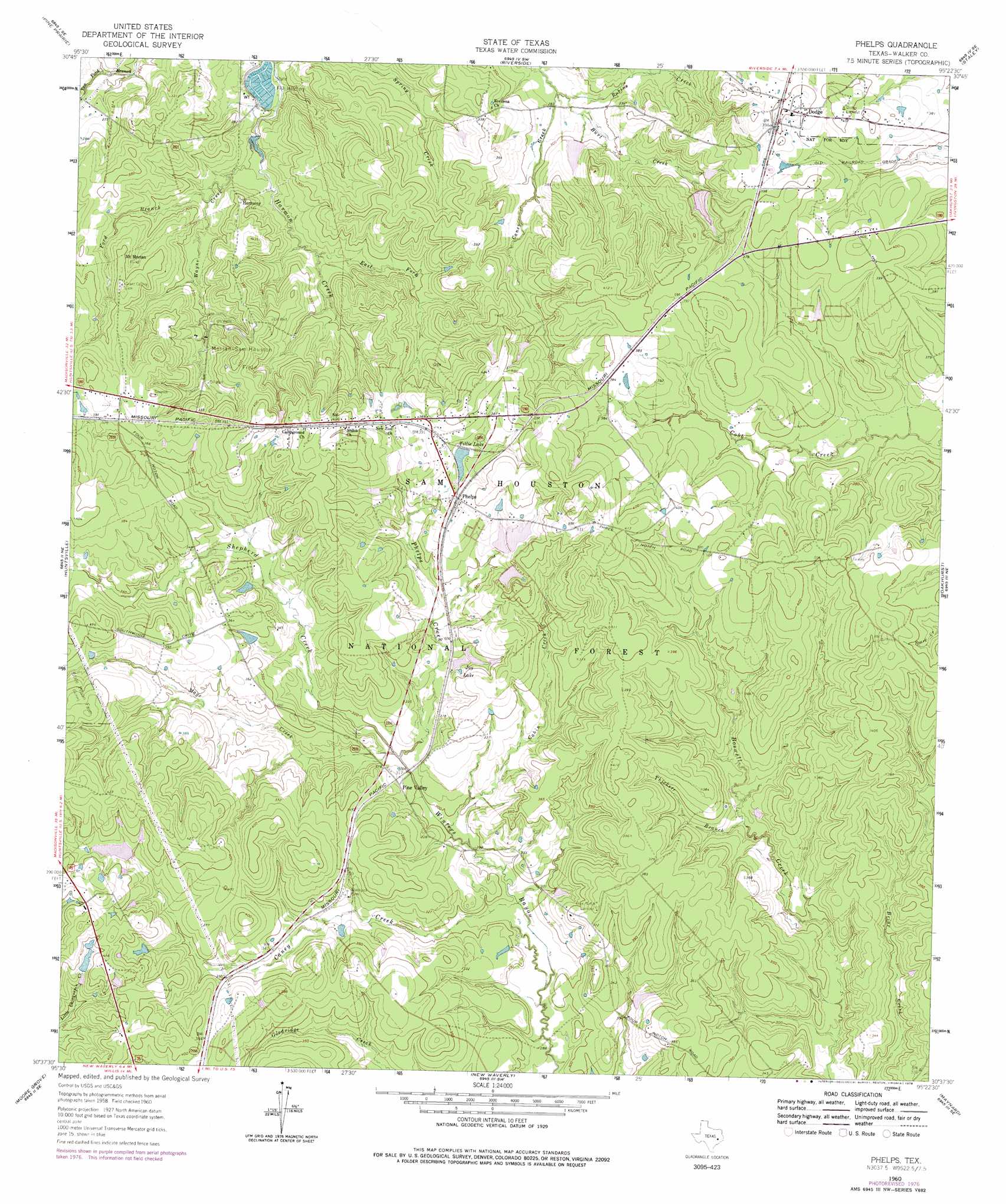
Phelps Topo Map Texas
To zoom in, hover over the map of Phelps
USGS Topo Quad 30095f4 - 1:24,000 scale
| Topo Map Name: | Phelps |
| USGS Topo Quad ID: | 30095f4 |
| Print Size: | ca. 21 1/4" wide x 27" high |
| Southeast Coordinates: | 30.625° N latitude / 95.375° W longitude |
| Map Center Coordinates: | 30.6875° N latitude / 95.4375° W longitude |
| U.S. State: | TX |
| Filename: | o30095f4.jpg |
| Download Map JPG Image: | Phelps topo map 1:24,000 scale |
| Map Type: | Topographic |
| Topo Series: | 7.5´ |
| Map Scale: | 1:24,000 |
| Source of Map Images: | United States Geological Survey (USGS) |
| Alternate Map Versions: |
Phelps TX 1960, updated 1963 Download PDF Buy paper map Phelps TX 1960, updated 1968 Download PDF Buy paper map Phelps TX 1960, updated 1978 Download PDF Buy paper map Phelps TX 1997, updated 2000 Download PDF Buy paper map Phelps TX 2010 Download PDF Buy paper map Phelps TX 2013 Download PDF Buy paper map Phelps TX 2016 Download PDF Buy paper map |
| FStopo: | US Forest Service topo Phelps is available: Download FStopo PDF Download FStopo TIF |
1:24,000 Topo Quads surrounding Phelps
Baker Lake |
Wyser Bottom |
Trinity West |
Trinity East |
Chita |
Crabbs Prairie |
Pine Prairie |
Riverside |
Staley |
Carlisle |
Galilee |
Huntsville |
Phelps |
Oakhurst |
Stephen Creek |
San Jacinto |
Moore Grove |
New Waverly |
Maynard |
Coldspring |
Montgomery |
Shepard Hill |
Willis |
Conroe Ne |
Bear Creek |
> Back to 30095e1 at 1:100,000 scale
> Back to 30094a1 at 1:250,000 scale
> Back to U.S. Topo Maps home
Phelps topo map: Gazetteer
Phelps: Dams
Hatchery Lake Dam elevation 76m 249′Maria Lake Dam elevation 93m 305′
McMillian Lake Dam elevation 104m 341′
Mitcham Lake Dam elevation 116m 380′
Tillie Lake Dam elevation 111m 364′
Watson East Dam elevation 114m 374′
Watson South Dam elevation 114m 374′
Watson West Dam elevation 111m 364′
Phelps: Lakes
Joy Lake elevation 102m 334′Phelps: Oilfields
Morian-Sam Houston Oil Field elevation 124m 406′Phelps: Populated Places
Dodge elevation 122m 400′Harmony elevation 95m 311′
Mount Morian elevation 97m 318′
Phelps elevation 115m 377′
Pine Valley elevation 98m 321′
Phelps: Reservoirs
Hatchery Lake elevation 76m 249′Maria Lake elevation 93m 305′
McMillian Lake elevation 104m 341′
Mitcham Lake elevation 116m 380′
Tillie Lake elevation 113m 370′
Watson East Lake elevation 114m 374′
Watson South Lake elevation 114m 374′
Watson West Lake elevation 111m 364′
Phelps: Streams
Burt Creek elevation 83m 272′Cabin Creek elevation 89m 291′
Caney Creek elevation 87m 285′
East Fork Harmon Creek elevation 81m 265′
Elder Creek elevation 98m 321′
Ford Branch elevation 82m 269′
Mays Creek elevation 90m 295′
Phelps Creek elevation 90m 295′
Robins Creek elevation 82m 269′
Shepherd Creek elevation 90m 295′
Thickett Branch elevation 93m 305′
Wayne Creek elevation 76m 249′
Phelps: Trails
Green Loop Trail elevation 117m 383′Lone Star Trail elevation 119m 390′
Phelps digital topo map on disk
Buy this Phelps topo map showing relief, roads, GPS coordinates and other geographical features, as a high-resolution digital map file on DVD: