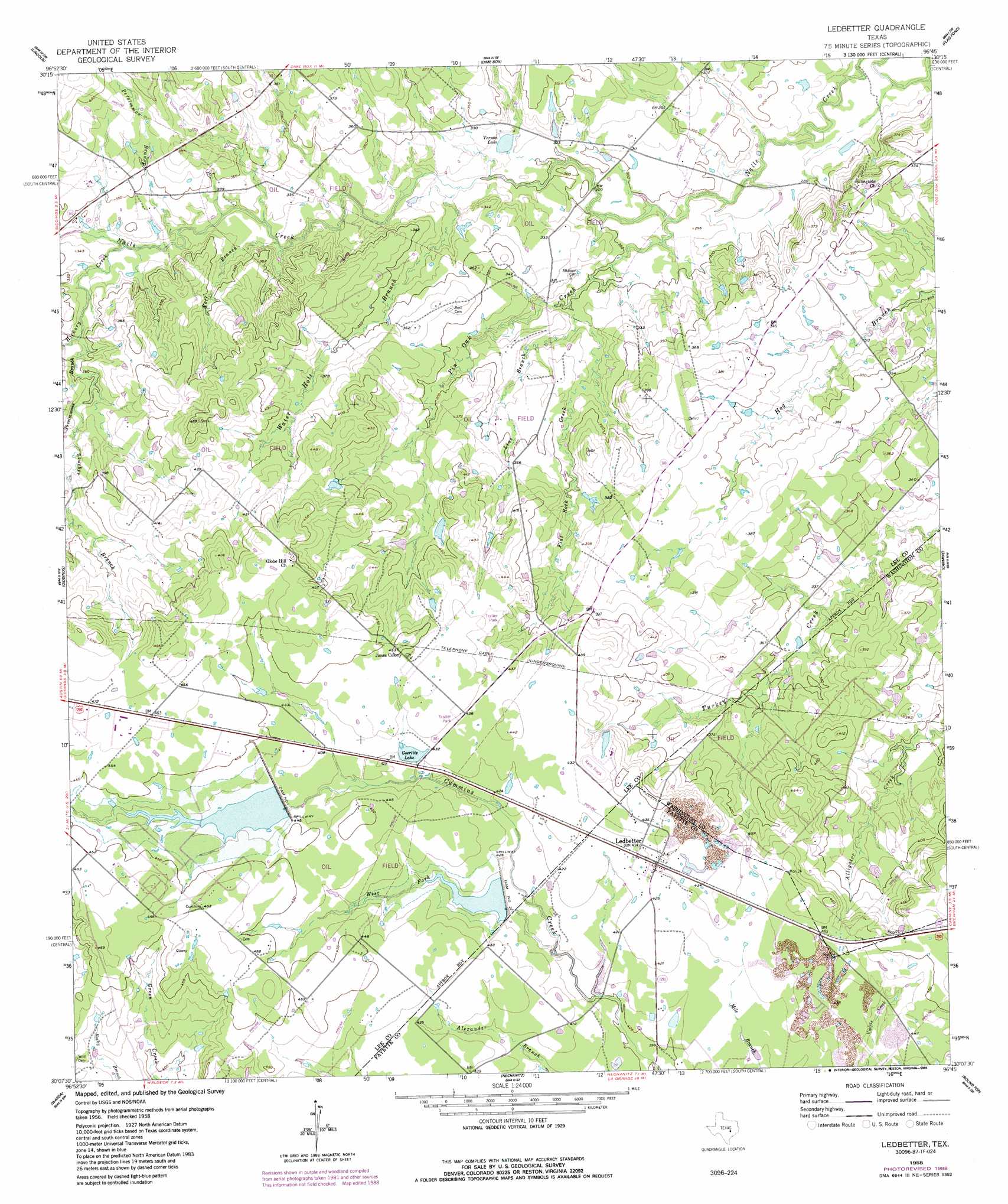
Ledbetter Topo Map Texas
To zoom in, hover over the map of Ledbetter
USGS Topo Quad 30096b7 - 1:24,000 scale
| Topo Map Name: | Ledbetter |
| USGS Topo Quad ID: | 30096b7 |
| Print Size: | ca. 21 1/4" wide x 27" high |
| Southeast Coordinates: | 30.125° N latitude / 96.75° W longitude |
| Map Center Coordinates: | 30.1875° N latitude / 96.8125° W longitude |
| U.S. State: | TX |
| Filename: | o30096b7.jpg |
| Download Map JPG Image: | Ledbetter topo map 1:24,000 scale |
| Map Type: | Topographic |
| Topo Series: | 7.5´ |
| Map Scale: | 1:24,000 |
| Source of Map Images: | United States Geological Survey (USGS) |
| Alternate Map Versions: |
Ledbetter TX 1958, updated 1959 Download PDF Buy paper map Ledbetter TX 1958, updated 1989 Download PDF Buy paper map Ledbetter TX 2010 Download PDF Buy paper map Ledbetter TX 2013 Download PDF Buy paper map Ledbetter TX 2016 Download PDF Buy paper map |
1:24,000 Topo Quads surrounding Ledbetter
Lexington |
Tanglewood |
Deanville |
Frenstat |
Lyons |
Fedor |
Lincoln |
Dime Box |
Flag Pond |
Somerville |
Paige |
Giddings |
Ledbetter |
Carmine |
Burton |
Winchester |
Warda |
Nechanitz |
Round Top |
Greenvine |
West Point |
La Grange West |
La Grange East |
Fayetteville |
Industry |
> Back to 30096a1 at 1:100,000 scale
> Back to 30096a1 at 1:250,000 scale
> Back to U.S. Topo Maps home
Ledbetter topo map: Gazetteer
Ledbetter: Airports
Bar S Ranch Airport elevation 142m 465′Ledbetter: Dams
Dam Number 1 elevation 134m 439′Dam Number 2 elevation 128m 419′
Goerlitz Lake Dam elevation 130m 426′
Soil Conservation Service Site 1 Dam elevation 131m 429′
Soil Conservation Service Site 2 Dam elevation 127m 416′
Ledbetter: Lakes
Goerlitz Lake elevation 131m 429′Vernon Lake elevation 94m 308′
Ledbetter: Populated Places
Ledbetter elevation 132m 433′Ledbetter: Reservoirs
Goerlitz Lake elevation 130m 426′Soil Conservation Service Site 1 Reservoir elevation 131m 429′
Soil Conservation Service Site 2 Reservoir elevation 127m 416′
Ledbetter: Streams
Flat Rock Creek elevation 93m 305′Hickory Creek elevation 98m 321′
Line Branch elevation 94m 308′
Persimmon Branch elevation 98m 321′
Persimmons Branch elevation 102m 334′
Pin Oak Creek elevation 88m 288′
Stueber Branch elevation 109m 357′
Water Hole Branch elevation 92m 301′
West Fork Cummins Creek elevation 122m 400′
Wolf Branch elevation 98m 321′
Ledbetter digital topo map on disk
Buy this Ledbetter topo map showing relief, roads, GPS coordinates and other geographical features, as a high-resolution digital map file on DVD: