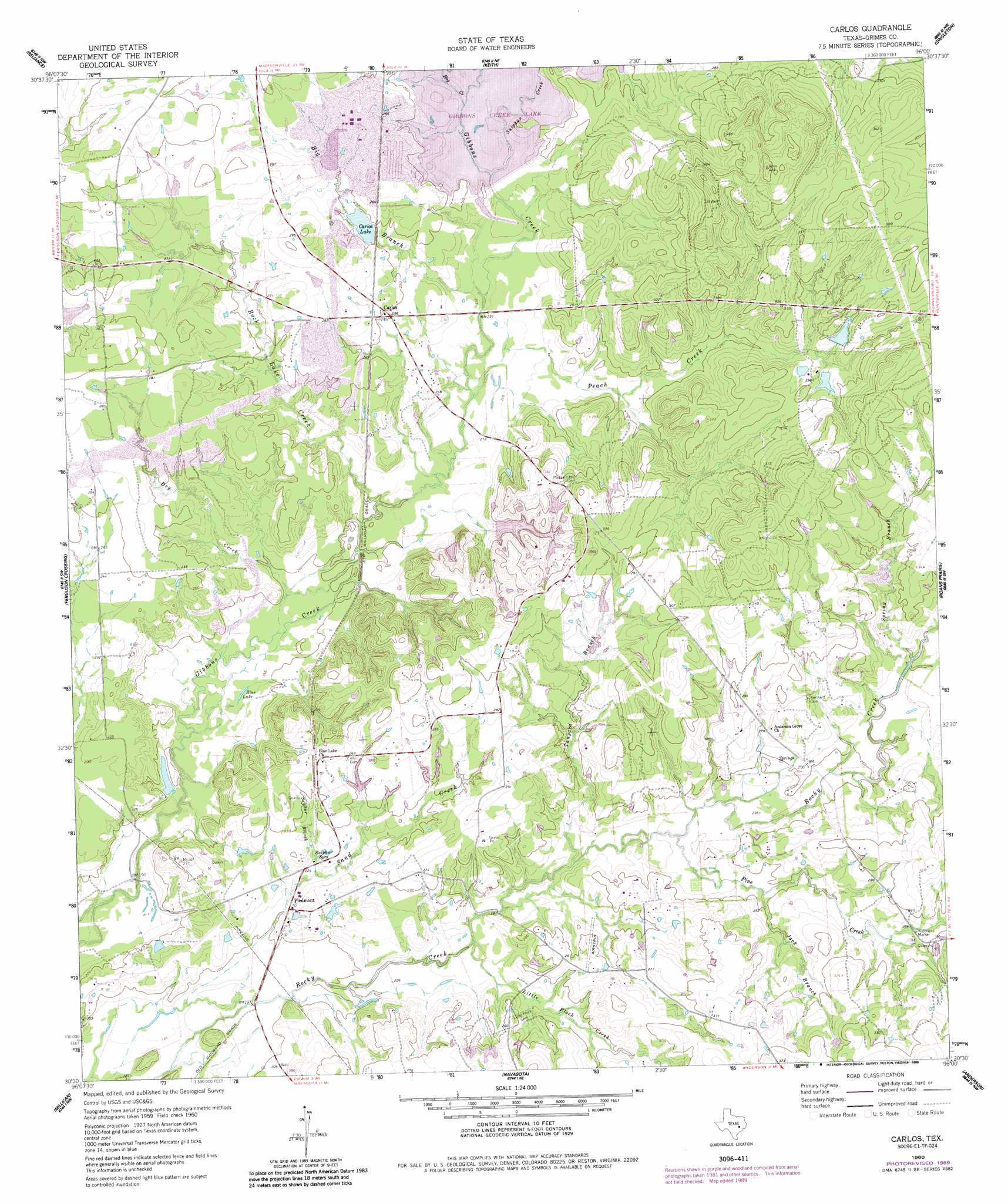
Carlos Topo Map Texas
To zoom in, hover over the map of Carlos
USGS Topo Quad 30096e1 - 1:24,000 scale
| Topo Map Name: | Carlos |
| USGS Topo Quad ID: | 30096e1 |
| Print Size: | ca. 21 1/4" wide x 27" high |
| Southeast Coordinates: | 30.5° N latitude / 96° W longitude |
| Map Center Coordinates: | 30.5625° N latitude / 96.0625° W longitude |
| U.S. State: | TX |
| Filename: | o30096e1.jpg |
| Download Map JPG Image: | Carlos topo map 1:24,000 scale |
| Map Type: | Topographic |
| Topo Series: | 7.5´ |
| Map Scale: | 1:24,000 |
| Source of Map Images: | United States Geological Survey (USGS) |
| Alternate Map Versions: |
Carlos TX 1960, updated 1962 Download PDF Buy paper map Carlos TX 1960, updated 1983 Download PDF Buy paper map Carlos TX 1960, updated 1987 Download PDF Buy paper map Carlos TX 1960, updated 1989 Download PDF Buy paper map Carlos TX 2010 Download PDF Buy paper map Carlos TX 2013 Download PDF Buy paper map Carlos TX 2016 Download PDF Buy paper map |
1:24,000 Topo Quads surrounding Carlos
Kurten |
Clear Lake |
Iola |
Bedias |
Steep Branch |
Bryan East |
Reliance |
Keith |
Singleton |
Loma |
Wellborn |
Ferguson Crossing |
Carlos |
Roans Prairie |
Richards |
Clay |
Millican |
Navasota |
Anderson |
Dacus |
Independence |
Washington |
Courtney |
Stoneham |
Plantersville |
> Back to 30096e1 at 1:100,000 scale
> Back to 30096a1 at 1:250,000 scale
> Back to U.S. Topo Maps home
Carlos topo map: Gazetteer
Carlos: Dams
Carlos Lake Dam elevation 75m 246′Farm Lake Dam elevation 91m 298′
Gibbons Creek Dam elevation 67m 219′
Moody Lake Dam elevation 60m 196′
Waltrip Lake Dam elevation 72m 236′
Carlos: Lakes
Blue Lake elevation 59m 193′Carlos: Parks
Fanthorp Inn State Historical Park elevation 97m 318′Carlos: Populated Places
Carlos elevation 76m 249′Piedmont elevation 66m 216′
Carlos: Reservoirs
Carlos Lake elevation 75m 246′Farm Lake elevation 91m 298′
Gibbons Creek Reservoir elevation 67m 219′
Moody Lake elevation 60m 196′
Waltrip Lake elevation 72m 236′
Carlos: Springs
Piedmont Springs elevation 76m 249′Sulphur Springs elevation 67m 219′
Carlos: Streams
Big Branch elevation 64m 209′Dry Creek elevation 59m 193′
Hog Creek elevation 75m 246′
Jack Branch elevation 73m 239′
Little Flock Creek elevation 64m 209′
Peach Creek elevation 64m 209′
Pine Creek elevation 67m 219′
Rock Lake Creek elevation 61m 200′
Spring Branch elevation 76m 249′
Sulphur Branch elevation 64m 209′
Sulphur Creek elevation 75m 246′
Tanyard Branch elevation 66m 216′
Carlos digital topo map on disk
Buy this Carlos topo map showing relief, roads, GPS coordinates and other geographical features, as a high-resolution digital map file on DVD: