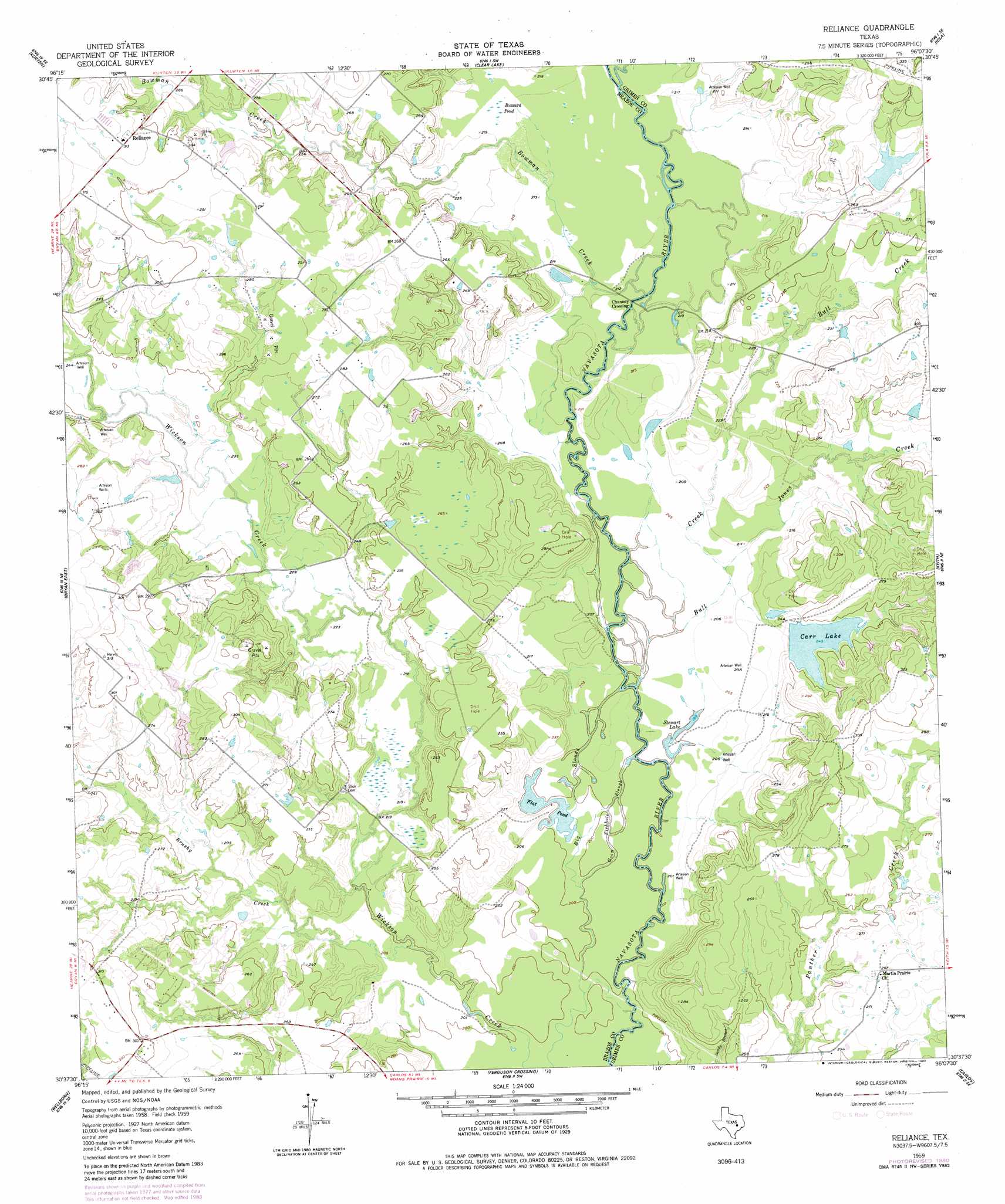
Reliance Topo Map Texas
To zoom in, hover over the map of Reliance
USGS Topo Quad 30096f2 - 1:24,000 scale
| Topo Map Name: | Reliance |
| USGS Topo Quad ID: | 30096f2 |
| Print Size: | ca. 21 1/4" wide x 27" high |
| Southeast Coordinates: | 30.625° N latitude / 96.125° W longitude |
| Map Center Coordinates: | 30.6875° N latitude / 96.1875° W longitude |
| U.S. State: | TX |
| Filename: | o30096f2.jpg |
| Download Map JPG Image: | Reliance topo map 1:24,000 scale |
| Map Type: | Topographic |
| Topo Series: | 7.5´ |
| Map Scale: | 1:24,000 |
| Source of Map Images: | United States Geological Survey (USGS) |
| Alternate Map Versions: |
Reliance TX 1959, updated 1960 Download PDF Buy paper map Reliance TX 1959, updated 1975 Download PDF Buy paper map Reliance TX 1959, updated 1980 Download PDF Buy paper map Reliance TX 1959, updated 1980 Download PDF Buy paper map Reliance TX 2010 Download PDF Buy paper map Reliance TX 2013 Download PDF Buy paper map Reliance TX 2016 Download PDF Buy paper map |
1:24,000 Topo Quads surrounding Reliance
Wheelock |
Edge |
Canary |
North Zulch |
Madisonville |
Dunn Creek |
Kurten |
Clear Lake |
Iola |
Bedias |
Bryan West |
Bryan East |
Reliance |
Keith |
Singleton |
Chances Store |
Wellborn |
Ferguson Crossing |
Carlos |
Roans Prairie |
Snook |
Clay |
Millican |
Navasota |
Anderson |
> Back to 30096e1 at 1:100,000 scale
> Back to 30096a1 at 1:250,000 scale
> Back to U.S. Topo Maps home
Reliance topo map: Gazetteer
Reliance: Airports
K Ranch Airport elevation 83m 272′Reliance: Dams
Brooke Lake Dam elevation 77m 252′Carr Lake Dam elevation 74m 242′
K-Ranch Lake Dam elevation 81m 265′
Reliance: Guts
Big Slough elevation 61m 200′Goon Fishhole Slough elevation 61m 200′
Reliance: Lakes
Flat Pond elevation 61m 200′Stewart Lake elevation 61m 200′
Reliance: Populated Places
Channey Crossing elevation 64m 209′Reliance elevation 94m 308′
Reliance: Reservoirs
Brooke Lake elevation 77m 252′Carr Lake elevation 74m 242′
K-Ranch Lake elevation 81m 265′
Reliance: Streams
Bowman Creek elevation 64m 209′Brushy Creek elevation 61m 200′
Bull Creek elevation 61m 200′
Jones Creek elevation 62m 203′
Steep Hollow Branch elevation 73m 239′
Reliance: Swamps
Buzzard Pond elevation 66m 216′Reliance digital topo map on disk
Buy this Reliance topo map showing relief, roads, GPS coordinates and other geographical features, as a high-resolution digital map file on DVD: