Milano Topo Map Texas
To zoom in, hover over the map of Milano
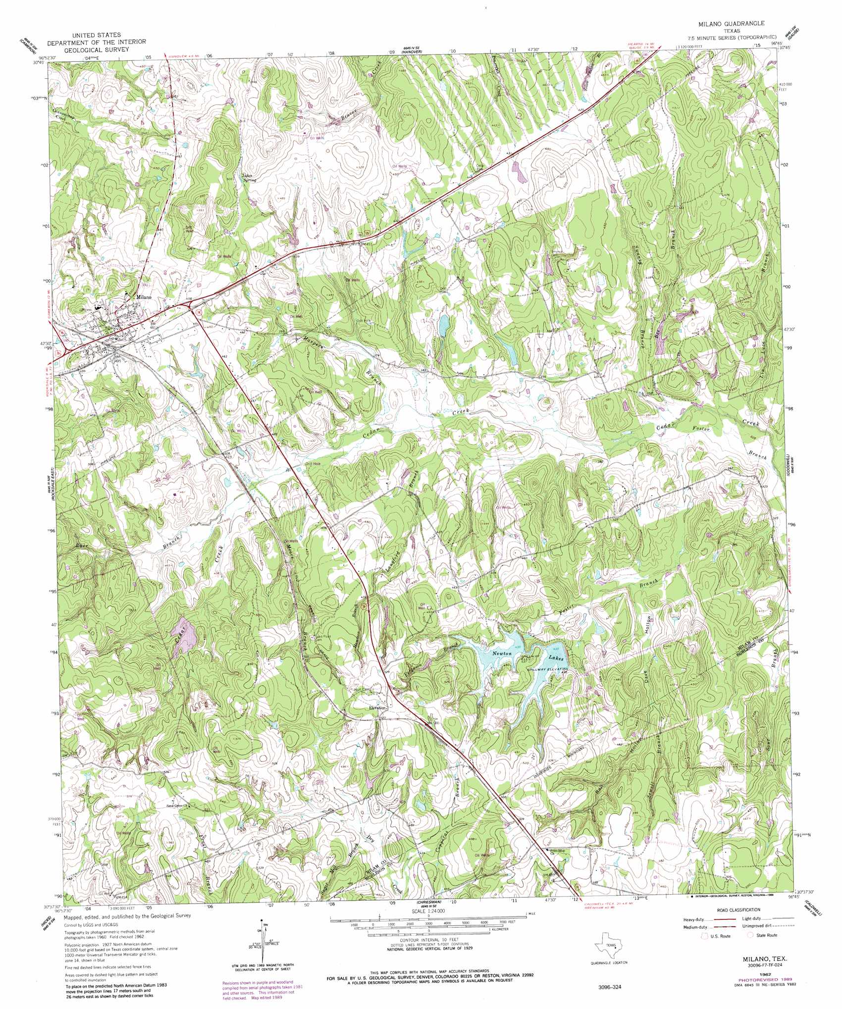
USGS Topo Quad 30096f7 - 1:24,000 scale
| Topo Map Name: | Milano |
| USGS Topo Quad ID: | 30096f7 |
| Print Size: | ca. 21 1/4" wide x 27" high |
| Southeast Coordinates: | 30.625° N latitude / 96.75° W longitude |
| Map Center Coordinates: | 30.6875° N latitude / 96.8125° W longitude |
| U.S. State: | TX |
| Filename: | o30096f7.jpg |
| Download Map JPG Image: | Milano topo map 1:24,000 scale |
| Map Type: | Topographic |
| Topo Series: | 7.5´ |
| Map Scale: | 1:24,000 |
| Source of Map Images: | United States Geological Survey (USGS) |
| Alternate Map Versions: |
Milano TX 1962, updated 1964 Download PDF Buy paper map Milano TX 1962, updated 1989 Download PDF Buy paper map Milano TX 2010 Download PDF Buy paper map Milano TX 2013 Download PDF Buy paper map Milano TX 2016 Download PDF Buy paper map |
1:24,000 Topo Quads surrounding Milano
Yarrelton |
Ben Arnold |
Maysfield |
Calvert |
Hearne North |
Pettibone |
Cameron |
Hanover |
Gause |
Hearne South |
Rockdale West |
Rockdale East |
Milano |
Goodwill |
Mumford |
Alcoa Lake |
Hicks |
Chriesman |
Caldwell |
Tunis |
Lexington |
Tanglewood |
Deanville |
Frenstat |
Lyons |
> Back to 30096e1 at 1:100,000 scale
> Back to 30096a1 at 1:250,000 scale
> Back to U.S. Topo Maps home
Milano topo map: Gazetteer
Milano: Dams
Bullock Lake Dam elevation 117m 383′Newton Lake Number 1 Dam elevation 132m 433′
Newton Lake Number 2 Dam elevation 136m 446′
Texas No Name Number 50 Dam elevation 124m 406′
Zalmanek Lake Dam elevation 134m 439′
Milano: Parks
Cedar Park elevation 137m 449′Milano: Populated Places
Elevation elevation 164m 538′Milano elevation 159m 521′
Milano: Reservoirs
Bullock Lake elevation 117m 383′Newton Lake Number 1 elevation 132m 433′
Newton Lake Number 2 elevation 136m 446′
Newton Lakes elevation 130m 426′
Texas No Name Number 50 Lake elevation 124m 406′
Zalmanek Lake elevation 134m 439′
Milano: Springs
Jakes Spring elevation 150m 492′Milano: Streams
Bee Branch elevation 100m 328′Buer Branch elevation 124m 406′
Copperas Branch elevation 131m 429′
Ferguson Branch elevation 116m 380′
Foster Branch elevation 96m 314′
Hammond Branch elevation 139m 456′
Harpers Branch elevation 109m 357′
Langford Branch elevation 105m 344′
Lin Luce Branch elevation 98m 321′
Moore Branch elevation 120m 393′
Sewell Branch elevation 110m 360′
Sugar Mill Branch elevation 131m 429′
Swanzy Branch elevation 101m 331′
Milano: Valleys
Dave Hollow elevation 111m 364′Devils Hollow elevation 110m 360′
Rail Hollow elevation 120m 393′
Milano digital topo map on disk
Buy this Milano topo map showing relief, roads, GPS coordinates and other geographical features, as a high-resolution digital map file on DVD: