Signal Hill Topo Map Texas
To zoom in, hover over the map of Signal Hill
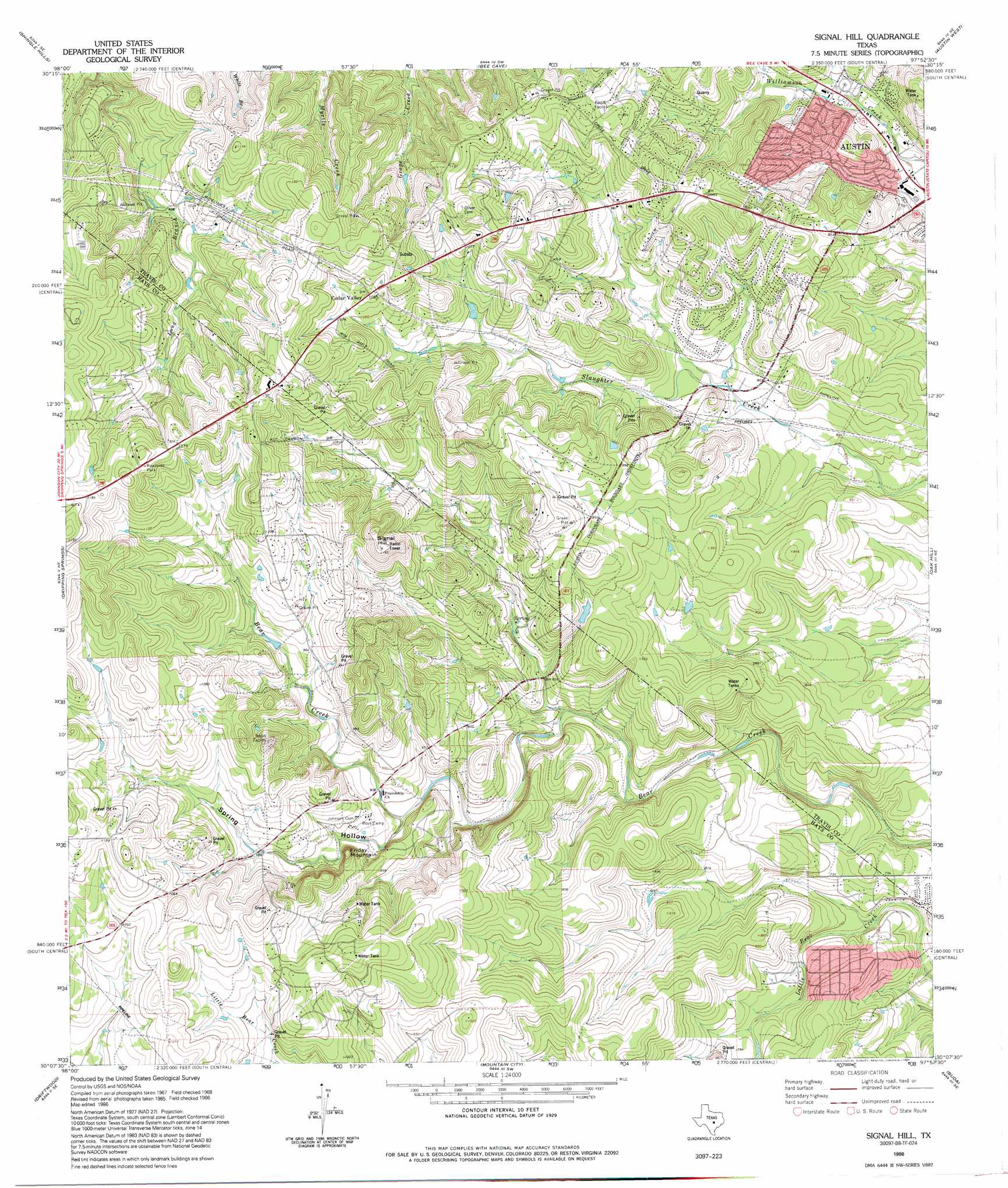
USGS Topo Quad 30097b8 - 1:24,000 scale
| Topo Map Name: | Signal Hill |
| USGS Topo Quad ID: | 30097b8 |
| Print Size: | ca. 21 1/4" wide x 27" high |
| Southeast Coordinates: | 30.125° N latitude / 97.875° W longitude |
| Map Center Coordinates: | 30.1875° N latitude / 97.9375° W longitude |
| U.S. State: | TX |
| Filename: | o30097b8.jpg |
| Download Map JPG Image: | Signal Hill topo map 1:24,000 scale |
| Map Type: | Topographic |
| Topo Series: | 7.5´ |
| Map Scale: | 1:24,000 |
| Source of Map Images: | United States Geological Survey (USGS) |
| Alternate Map Versions: |
Signal Hill TX 1968, updated 1971 Download PDF Buy paper map Signal Hill TX 1968, updated 1974 Download PDF Buy paper map Signal Hill TX 1968, updated 1983 Download PDF Buy paper map Signal Hill TX 1986, updated 1986 Download PDF Buy paper map Signal Hill TX 1986, updated 1995 Download PDF Buy paper map Signal Hill TX 2010 Download PDF Buy paper map Signal Hill TX 2013 Download PDF Buy paper map Signal Hill TX 2016 Download PDF Buy paper map |
1:24,000 Topo Quads surrounding Signal Hill
Spicewood |
Pace Bend |
Mansfield Dam |
Jollyville |
Pflugerville West |
Hammetts Crossing |
Shingle Hills |
Bee Cave |
Austin West |
Austin East |
Henly |
Dripping Springs |
Signal Hill |
Oak Hill |
Montopolis |
Rough Hollow |
Driftwood |
Mountain City |
Buda |
Creedmoor |
Devils Backbone |
Wimberley |
San Marcos North |
Uhland |
Lockhart North |
> Back to 30097a1 at 1:100,000 scale
> Back to 30096a1 at 1:250,000 scale
> Back to U.S. Topo Maps home
Signal Hill topo map: Gazetteer
Signal Hill: Airports
Johnny Voudouris Heliport elevation 323m 1059′Signal Hill: Populated Places
Bear Creek elevation 302m 990′Cedar Valley elevation 333m 1092′
Signal Hill: Summits
Friday Mountain elevation 323m 1059′Signal Hill elevation 353m 1158′
Signal Hill: Trails
Circle C Slaughter Creek Trail elevation 265m 869′Rim Rock Trail elevation 329m 1079′
Signal Hill: Valleys
Spring Hollow elevation 271m 889′Signal Hill digital topo map on disk
Buy this Signal Hill topo map showing relief, roads, GPS coordinates and other geographical features, as a high-resolution digital map file on DVD: