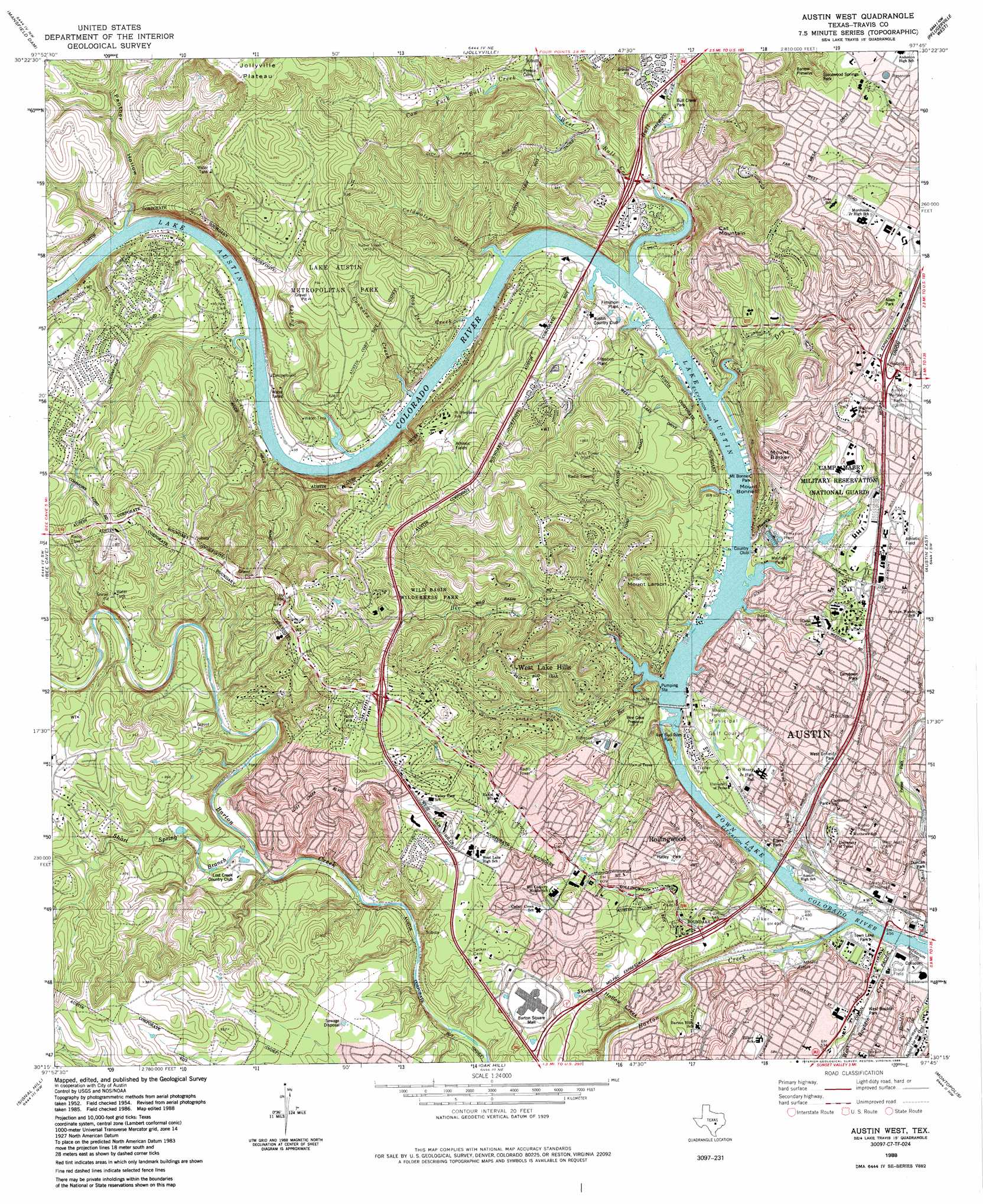
Austin West Topo Map Texas
To zoom in, hover over the map of Austin West
USGS Topo Quad 30097c7 - 1:24,000 scale
| Topo Map Name: | Austin West |
| USGS Topo Quad ID: | 30097c7 |
| Print Size: | ca. 21 1/4" wide x 27" high |
| Southeast Coordinates: | 30.25° N latitude / 97.75° W longitude |
| Map Center Coordinates: | 30.3125° N latitude / 97.8125° W longitude |
| U.S. State: | TX |
| Filename: | o30097c7.jpg |
| Download Map JPG Image: | Austin West topo map 1:24,000 scale |
| Map Type: | Topographic |
| Topo Series: | 7.5´ |
| Map Scale: | 1:24,000 |
| Source of Map Images: | United States Geological Survey (USGS) |
| Alternate Map Versions: |
Austin West TX 1954, updated 1956 Download PDF Buy paper map Austin West TX 1966, updated 1969 Download PDF Buy paper map Austin West TX 1966, updated 1974 Download PDF Buy paper map Austin West TX 1966, updated 1981 Download PDF Buy paper map Austin West TX 1966, updated 1985 Download PDF Buy paper map Austin West TX 1988, updated 1988 Download PDF Buy paper map Austin West TX 2010 Download PDF Buy paper map Austin West TX 2013 Download PDF Buy paper map Austin West TX 2016 Download PDF Buy paper map |
1:24,000 Topo Quads surrounding Austin West
Travis Peak |
Nameless |
Leander |
Round Rock |
Hutto |
Pace Bend |
Mansfield Dam |
Jollyville |
Pflugerville West |
Pflugerville East |
Shingle Hills |
Bee Cave |
Austin West |
Austin East |
Manor |
Dripping Springs |
Signal Hill |
Oak Hill |
Montopolis |
Webberville |
Driftwood |
Mountain City |
Buda |
Creedmoor |
Lytton Springs |
> Back to 30097a1 at 1:100,000 scale
> Back to 30096a1 at 1:250,000 scale
> Back to U.S. Topo Maps home
Austin West topo map: Gazetteer
Austin West: Airports
Mabry Army Heliport elevation 186m 610′Ossiport Heliport elevation 235m 770′
Austin West: Bridges
Lamar Boulevard Bridge elevation 131m 429′Austin West: Dams
Tom Miller Dam elevation 148m 485′Austin West: Parks
Allen Memorial County Park elevation 237m 777′Barrow Preserve elevation 218m 715′
Bee Caves Preserve elevation 176m 577′
Bright Leaf State Natural Area elevation 180m 590′
Bull Creek Park elevation 169m 554′
Butler Park elevation 136m 446′
Covert Park elevation 207m 679′
Deep Eddy Park elevation 139m 456′
Disch Field elevation 139m 456′
Duncan Park elevation 143m 469′
House Park elevation 146m 479′
Lake Austin Metropolitan elevation 219m 718′
Lamar Beach elevation 134m 439′
Mayfield Park elevation 162m 531′
Mount Bonnell Park elevation 157m 515′
Northwest Little League Field elevation 209m 685′
Northwest Recreation Center elevation 208m 682′
Pease Park elevation 148m 485′
Perry Park elevation 211m 692′
Red Bud Isle Park elevation 144m 472′
Reed Park elevation 158m 518′
Regents School of Austin Football Field elevation 255m 836′
Rudolph Gamblin Field elevation 156m 511′
Saint Michaels Academy Baseball Field elevation 255m 836′
Saint Michaels Academy Football Stadium and Track elevation 255m 836′
Saint Michaels Academy Softball Field elevation 255m 836′
Saint Stephens Episcopal School Baseball Field elevation 221m 725′
Saint Stephens Episcopal School Football Stadium elevation 218m 715′
West Austin Park elevation 159m 521′
Westenfield Park elevation 164m 538′
Westlake Stadium elevation 233m 764′
Wild Basin Wilderness Park elevation 247m 810′
Zilker Park elevation 149m 488′
Austin West: Populated Places
Barton Creek elevation 250m 820′Greenshores elevation 160m 524′
Lost Creek elevation 251m 823′
River Hills elevation 152m 498′
Rollingwood elevation 197m 646′
West Lake Hills elevation 238m 780′
Austin West: Post Offices
Chimney Corners Post Office elevation 246m 807′West Austin Post Office elevation 184m 603′
Austin West: Reservoirs
Lake Austin elevation 148m 485′Austin West: Springs
Back Door Spring elevation 175m 574′Barton Springs elevation 137m 449′
Deep Eddy Spring elevation 131m 429′
Eliza Spring elevation 140m 459′
Mormon Spring elevation 151m 495′
Mount Bonnell Spring elevation 149m 488′
Old Mill Spring elevation 142m 465′
Power House Spring elevation 133m 436′
Upper Barton Spring elevation 138m 452′
Austin West: Streams
Barton Creek elevation 131m 429′Bee Creek elevation 147m 482′
Bull Creek elevation 148m 485′
Coldwater Creek elevation 147m 482′
Connors Creek elevation 147m 482′
Cow Fork elevation 184m 603′
Dry Creek elevation 147m 482′
Hog Pen Creek elevation 147m 482′
Hucks Slough elevation 151m 495′
Johnson Branch elevation 132m 433′
Little Bee Creek elevation 147m 482′
Short Spring Branch elevation 182m 597′
Skunk Hollow Creek elevation 146m 479′
Turkey Creek elevation 147m 482′
West Bouldin Creek elevation 131m 429′
West Bull Creek elevation 151m 495′
Austin West: Summits
Cat Mountain elevation 283m 928′Mount Barker elevation 257m 843′
Mount Bonnell elevation 238m 780′
Mount Larson elevation 277m 908′
Mount Lucas elevation 250m 820′
Austin West: Trails
Allen Park Trail elevation 226m 741′Bee Creek Trail elevation 188m 616′
Lake Trail elevation 165m 541′
Red Bud elevation 272m 892′
Ridge Trail elevation 165m 541′
Spicewood Springs Preserve Trail elevation 270m 885′
Turkey Creek Trail elevation 173m 567′
West Bouldin Creek Trail elevation 140m 459′
Zilker Park Hike and Bike Trail elevation 148m 485′
Austin West: Valleys
Panther Hollow elevation 152m 498′Austin West digital topo map on disk
Buy this Austin West topo map showing relief, roads, GPS coordinates and other geographical features, as a high-resolution digital map file on DVD: