Beaukiss Topo Map Texas
To zoom in, hover over the map of Beaukiss
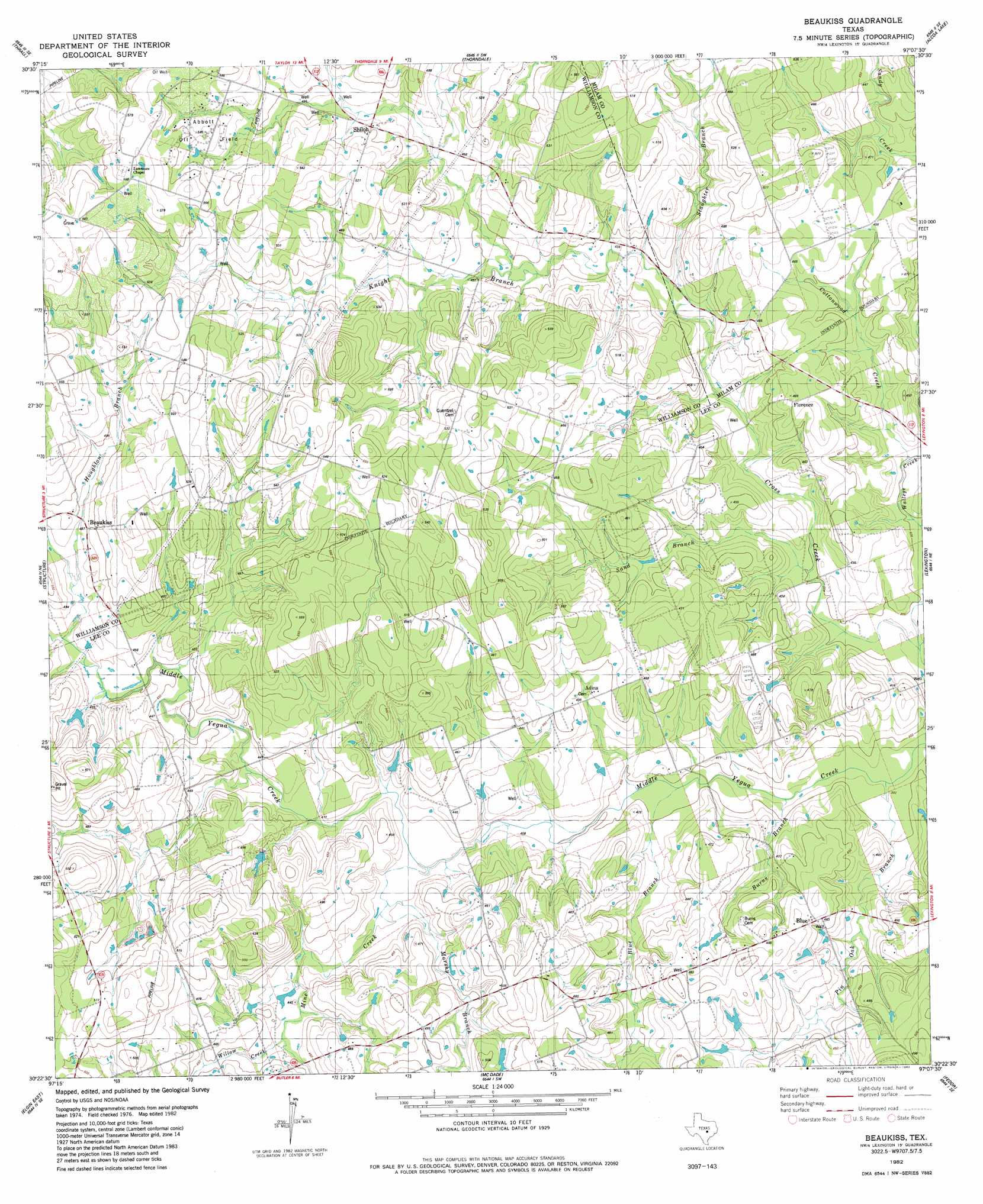
USGS Topo Quad 30097d2 - 1:24,000 scale
| Topo Map Name: | Beaukiss |
| USGS Topo Quad ID: | 30097d2 |
| Print Size: | ca. 21 1/4" wide x 27" high |
| Southeast Coordinates: | 30.375° N latitude / 97.125° W longitude |
| Map Center Coordinates: | 30.4375° N latitude / 97.1875° W longitude |
| U.S. State: | TX |
| Filename: | o30097d2.jpg |
| Download Map JPG Image: | Beaukiss topo map 1:24,000 scale |
| Map Type: | Topographic |
| Topo Series: | 7.5´ |
| Map Scale: | 1:24,000 |
| Source of Map Images: | United States Geological Survey (USGS) |
| Alternate Map Versions: |
Beaukiss TX 1982, updated 1982 Download PDF Buy paper map Beaukiss TX 2010 Download PDF Buy paper map Beaukiss TX 2012 Download PDF Buy paper map Beaukiss TX 2016 Download PDF Buy paper map |
1:24,000 Topo Quads surrounding Beaukiss
Granger |
Friendship |
San Gabriel |
Rockdale West |
Rockdale East |
Taylor |
Thrall |
Thorndale |
Alcoa Lake |
Hicks |
Coupland |
Structure |
Beaukiss |
Lexington |
Tanglewood |
Elgin West |
Elgin East |
Mcdade |
Fedor |
Lincoln |
Utley |
Lake Bastrop |
Smithville Nw |
Paige |
Giddings |
> Back to 30097a1 at 1:100,000 scale
> Back to 30096a1 at 1:250,000 scale
> Back to U.S. Topo Maps home
Beaukiss topo map: Gazetteer
Beaukiss: Airports
Wood Triple d Airport elevation 149m 488′Beaukiss: Dams
Draeger Lake Dam elevation 139m 456′Beaukiss: Oilfields
Abbott Oil Field elevation 162m 531′Beaukiss: Populated Places
Adina elevation 134m 439′Beaukiss elevation 149m 488′
Blue elevation 143m 469′
Shiloh elevation 151m 495′
Beaukiss: Reservoirs
Draeger Lake elevation 139m 456′Beaukiss: Streams
Blue Branch elevation 120m 393′Burns Branch elevation 119m 390′
Cottonwood Creek elevation 122m 400′
Houghton Branch elevation 140m 459′
Knight Branch elevation 128m 419′
Marshy Branch elevation 127m 416′
Mine Creek elevation 125m 410′
Sand Branch elevation 123m 403′
Slaughter Branch elevation 125m 410′
Willow Creek elevation 133m 436′
Beaukiss: Summits
Clay Hill elevation 138m 452′Beaukiss digital topo map on disk
Buy this Beaukiss topo map showing relief, roads, GPS coordinates and other geographical features, as a high-resolution digital map file on DVD: