Structure Topo Map Texas
To zoom in, hover over the map of Structure
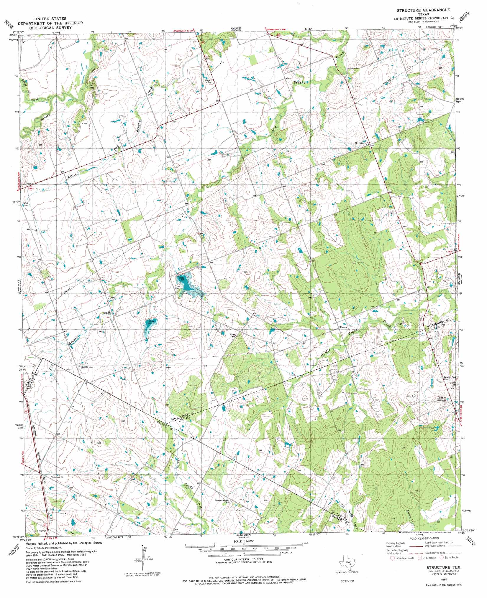
USGS Topo Quad 30097d3 - 1:24,000 scale
| Topo Map Name: | Structure |
| USGS Topo Quad ID: | 30097d3 |
| Print Size: | ca. 21 1/4" wide x 27" high |
| Southeast Coordinates: | 30.375° N latitude / 97.25° W longitude |
| Map Center Coordinates: | 30.4375° N latitude / 97.3125° W longitude |
| U.S. State: | TX |
| Filename: | o30097d3.jpg |
| Download Map JPG Image: | Structure topo map 1:24,000 scale |
| Map Type: | Topographic |
| Topo Series: | 7.5´ |
| Map Scale: | 1:24,000 |
| Source of Map Images: | United States Geological Survey (USGS) |
| Alternate Map Versions: |
Structure TX 1982, updated 1982 Download PDF Buy paper map Structure TX 2010 Download PDF Buy paper map Structure TX 2013 Download PDF Buy paper map Structure TX 2016 Download PDF Buy paper map |
1:24,000 Topo Quads surrounding Structure
Weir |
Granger |
Friendship |
San Gabriel |
Rockdale West |
Hutto |
Taylor |
Thrall |
Thorndale |
Alcoa Lake |
Pflugerville East |
Coupland |
Structure |
Beaukiss |
Lexington |
Manor |
Elgin West |
Elgin East |
Mcdade |
Fedor |
Webberville |
Utley |
Lake Bastrop |
Smithville Nw |
Paige |
> Back to 30097a1 at 1:100,000 scale
> Back to 30096a1 at 1:250,000 scale
> Back to U.S. Topo Maps home
Structure topo map: Gazetteer
Structure: Airports
Barton Field elevation 158m 518′Chan-C Airport elevation 162m 531′
Sundbeck Ranch Airport elevation 165m 541′
Structure: Dams
Soil Conservation Service Site 12 Dam elevation 166m 544′Soil Conservation Service Site 13 Dam elevation 161m 528′
Structure: Populated Places
Pleasant Grove (historical) elevation 161m 528′Siloam elevation 151m 495′
Structure elevation 171m 561′
Type elevation 181m 593′
Structure: Reservoirs
Soil Conservation Service Site 12 Reservoir elevation 166m 544′Soil Conservation Service Site 13 Reservoir elevation 161m 528′
Structure: Springs
Lawhon Springs elevation 164m 538′Structure: Streams
Boggy Creek elevation 144m 472′Structure digital topo map on disk
Buy this Structure topo map showing relief, roads, GPS coordinates and other geographical features, as a high-resolution digital map file on DVD: