Pflugerville East Topo Map Texas
To zoom in, hover over the map of Pflugerville East
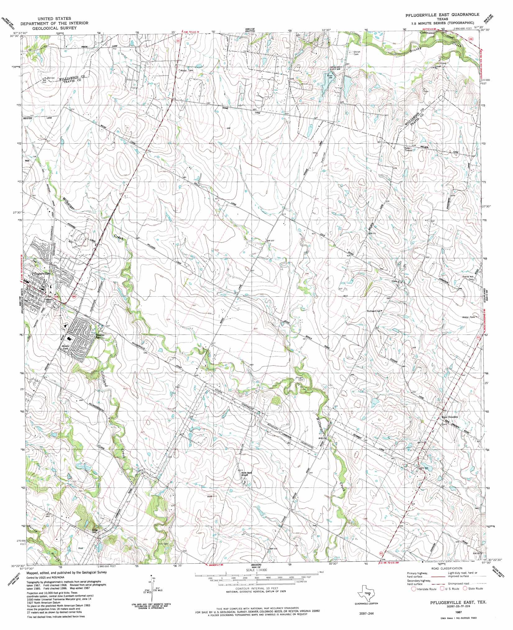
USGS Topo Quad 30097d5 - 1:24,000 scale
| Topo Map Name: | Pflugerville East |
| USGS Topo Quad ID: | 30097d5 |
| Print Size: | ca. 21 1/4" wide x 27" high |
| Southeast Coordinates: | 30.375° N latitude / 97.5° W longitude |
| Map Center Coordinates: | 30.4375° N latitude / 97.5625° W longitude |
| U.S. State: | TX |
| Filename: | o30097d5.jpg |
| Download Map JPG Image: | Pflugerville East topo map 1:24,000 scale |
| Map Type: | Topographic |
| Topo Series: | 7.5´ |
| Map Scale: | 1:24,000 |
| Source of Map Images: | United States Geological Survey (USGS) |
| Alternate Map Versions: |
Pflugerville East TX 1968, updated 1971 Download PDF Buy paper map Pflugerville East TX 1968, updated 1975 Download PDF Buy paper map Pflugerville East TX 1968, updated 1984 Download PDF Buy paper map Pflugerville East TX 1987, updated 1988 Download PDF Buy paper map Pflugerville East TX 2010 Download PDF Buy paper map Pflugerville East TX 2013 Download PDF Buy paper map Pflugerville East TX 2016 Download PDF Buy paper map |
1:24,000 Topo Quads surrounding Pflugerville East
Leander Ne |
Georgetown |
Weir |
Granger |
Friendship |
Leander |
Round Rock |
Hutto |
Taylor |
Thrall |
Jollyville |
Pflugerville West |
Pflugerville East |
Coupland |
Structure |
Austin West |
Austin East |
Manor |
Elgin West |
Elgin East |
Oak Hill |
Montopolis |
Webberville |
Utley |
Lake Bastrop |
> Back to 30097a1 at 1:100,000 scale
> Back to 30096a1 at 1:250,000 scale
> Back to U.S. Topo Maps home
Pflugerville East topo map: Gazetteer
Pflugerville East: Airports
Birds Nest Airport elevation 187m 613′Pflugerville East: Dams
Cavness Lake Dam elevation 170m 557′Raesz Lake Dam elevation 160m 524′
Soil Conservation Service Site 22 Dam elevation 183m 600′
Texas No Name Number 8 Dam elevation 180m 590′
Zimmerhanzel Lake Dam elevation 178m 583′
Pflugerville East: Parks
Mustang Stadium elevation 181m 593′Pfluger Park elevation 212m 695′
Pflugerville East: Populated Places
Cele elevation 170m 557′New Sweden elevation 169m 554′
Pflugerville elevation 219m 718′
Pflugerville East: Reservoirs
Cavness Lake elevation 170m 557′Raesz Lake elevation 160m 524′
Soil Conservation Service Site 22 Reservoir elevation 183m 600′
Zimmerhanzel Lake elevation 178m 583′
Pflugerville East: Streams
Cottonwood Creek elevation 167m 547′Pflugerville East digital topo map on disk
Buy this Pflugerville East topo map showing relief, roads, GPS coordinates and other geographical features, as a high-resolution digital map file on DVD: