Davilla Topo Map Texas
To zoom in, hover over the map of Davilla
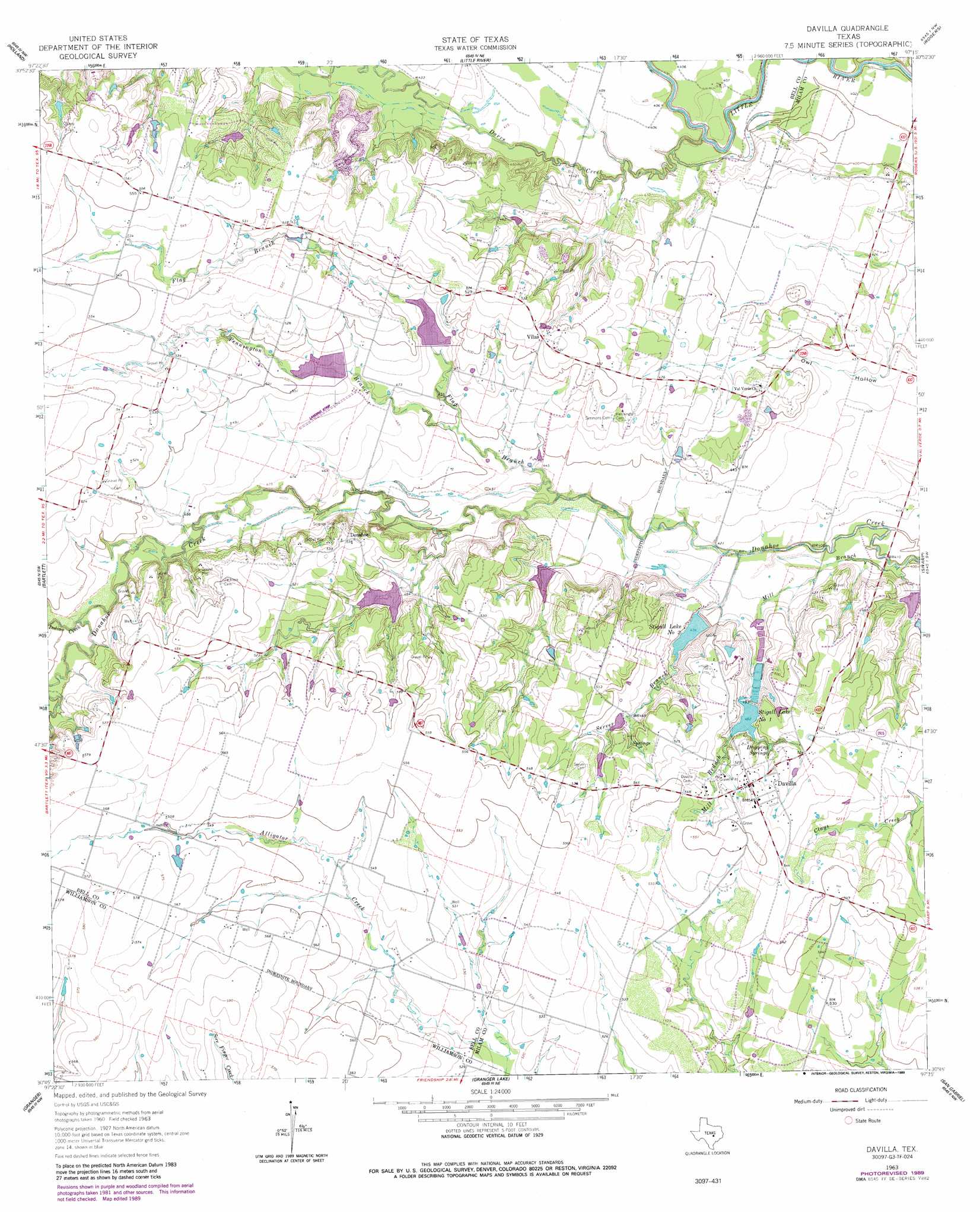
USGS Topo Quad 30097g3 - 1:24,000 scale
| Topo Map Name: | Davilla |
| USGS Topo Quad ID: | 30097g3 |
| Print Size: | ca. 21 1/4" wide x 27" high |
| Southeast Coordinates: | 30.75° N latitude / 97.25° W longitude |
| Map Center Coordinates: | 30.8125° N latitude / 97.3125° W longitude |
| U.S. State: | TX |
| Filename: | o30097g3.jpg |
| Download Map JPG Image: | Davilla topo map 1:24,000 scale |
| Map Type: | Topographic |
| Topo Series: | 7.5´ |
| Map Scale: | 1:24,000 |
| Source of Map Images: | United States Geological Survey (USGS) |
| Alternate Map Versions: |
Davilla TX 1963, updated 1965 Download PDF Buy paper map Davilla TX 1963, updated 1989 Download PDF Buy paper map Davilla TX 2010 Download PDF Buy paper map Davilla TX 2013 Download PDF Buy paper map Davilla TX 2016 Download PDF Buy paper map |
1:24,000 Topo Quads surrounding Davilla
Nolanville |
Belton |
Temple |
Seaton |
Westphalia |
Salado |
Holland |
Little River |
Rogers |
Yarrelton |
Jarrell |
Bartlett |
Davilla |
Sharp |
Pettibone |
Weir |
Granger |
Friendship |
San Gabriel |
Rockdale West |
Hutto |
Taylor |
Thrall |
Thorndale |
Alcoa Lake |
> Back to 30097e1 at 1:100,000 scale
> Back to 30096a1 at 1:250,000 scale
> Back to U.S. Topo Maps home
Davilla topo map: Gazetteer
Davilla: Airports
Isbell Ranch Airport elevation 128m 419′Davilla: Dams
Brenni Lake Dam elevation 157m 515′Neusch Lake Number 1 Dam elevation 140m 459′
Soil Conservation Service Site 5 Dam elevation 146m 479′
Soil Conservation Service Site 6 Dam elevation 143m 469′
Soil Conservation Service Site 7 Dam elevation 141m 462′
Soil Conservation Service Site 8 Dam elevation 136m 446′
Soil Conservation Service Site 9 Dam elevation 122m 400′
Stigall Lake Number 2 Dam elevation 134m 439′
Davilla: Populated Places
Davilla elevation 166m 544′Donahoe elevation 162m 531′
Vilas elevation 156m 511′
Davilla: Reservoirs
Brenni Lake elevation 157m 515′Neusch Lake Number 1 elevation 140m 459′
Soil Conservation Service Site 5 Reservoir elevation 146m 479′
Soil Conservation Service Site 6 Reservoir elevation 143m 469′
Soil Conservation Service Site 7 Reservoir elevation 141m 462′
Soil Conservation Service Site 8 Reservoir elevation 136m 446′
Soil Conservation Service Site 9 Reservoir elevation 122m 400′
Stigall Lake Number 2 elevation 134m 439′
Stigall Lake Number One elevation 149m 488′
Stigall Lake Number Two elevation 134m 439′
Davilla: Springs
Dripping Springs elevation 153m 501′Davilla: Streams
Darrs Creek elevation 117m 383′Flag Branch elevation 131m 429′
Indian Creek elevation 146m 479′
Mill Branch elevation 119m 390′
Pennington Branch elevation 136m 446′
Server Branch elevation 125m 410′
Davilla digital topo map on disk
Buy this Davilla topo map showing relief, roads, GPS coordinates and other geographical features, as a high-resolution digital map file on DVD: