Ding Dong Topo Map Texas
To zoom in, hover over the map of Ding Dong
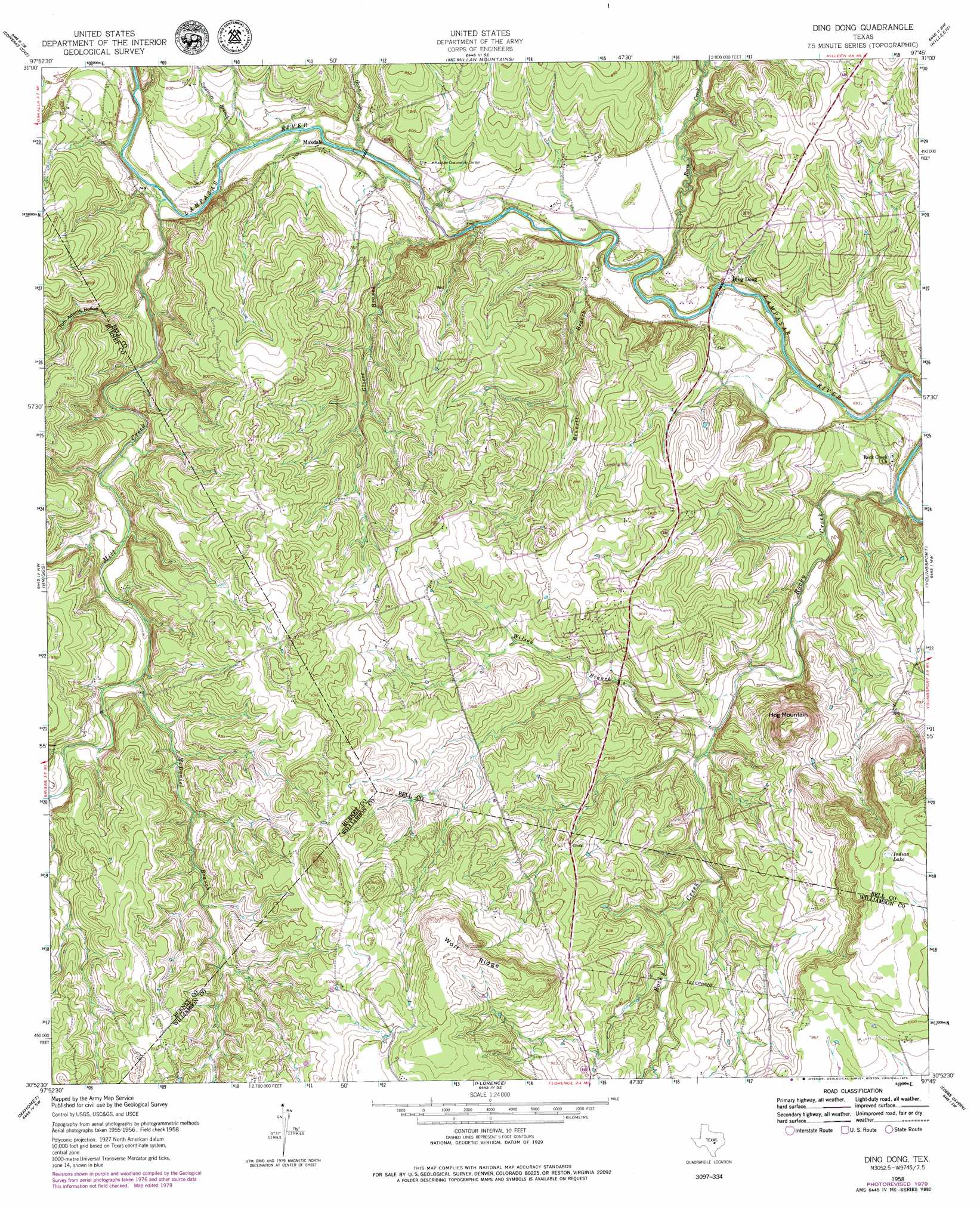
USGS Topo Quad 30097h7 - 1:24,000 scale
| Topo Map Name: | Ding Dong |
| USGS Topo Quad ID: | 30097h7 |
| Print Size: | ca. 21 1/4" wide x 27" high |
| Southeast Coordinates: | 30.875° N latitude / 97.75° W longitude |
| Map Center Coordinates: | 30.9375° N latitude / 97.8125° W longitude |
| U.S. State: | TX |
| Filename: | o30097h7.jpg |
| Download Map JPG Image: | Ding Dong topo map 1:24,000 scale |
| Map Type: | Topographic |
| Topo Series: | 7.5´ |
| Map Scale: | 1:24,000 |
| Source of Map Images: | United States Geological Survey (USGS) |
| Alternate Map Versions: |
Ding Dong TX 1958, updated 1961 Download PDF Buy paper map Ding Dong TX 1958, updated 1975 Download PDF Buy paper map Ding Dong TX 1958, updated 1979 Download PDF Buy paper map Ding Dong TX 1958, updated 1979 Download PDF Buy paper map Ding Dong TX 2010 Download PDF Buy paper map Ding Dong TX 2013 Download PDF Buy paper map Ding Dong TX 2016 Download PDF Buy paper map |
1:24,000 Topo Quads surrounding Ding Dong
Rumley |
Twin Mountains |
Fort Hood |
Post Oak Mountain |
Bland |
Kempner |
Copperas Cove |
Mcmillan Mountains |
Killeen |
Nolanville |
Bachelor Peak |
Briggs |
Ding Dong |
Youngsport |
Salado |
Joppa |
Mahomet |
Florence |
Cobbs Cavern |
Jarrell |
Bertram |
Liberty Hill |
Leander Ne |
Georgetown |
Weir |
> Back to 30097e1 at 1:100,000 scale
> Back to 30096a1 at 1:250,000 scale
> Back to U.S. Topo Maps home
Ding Dong topo map: Gazetteer
Ding Dong: Airports
Fisher Ranch Airport elevation 261m 856′White Airport elevation 271m 889′
Ding Dong: Lakes
Indian Lake elevation 315m 1033′Ding Dong: Populated Places
Ding Dong elevation 218m 715′Ding Dong elevation 255m 836′
Maxdale elevation 228m 748′
Ding Dong: Ridges
Wolf Ridge elevation 337m 1105′Ding Dong: Streams
Bennett Branch elevation 210m 688′Gann Branch elevation 219m 718′
Glover Branch elevation 213m 698′
McDaniel Branch elevation 249m 816′
Mill Creek elevation 219m 718′
Reese Creek elevation 219m 718′
Rocky Creek elevation 200m 656′
Sycamore Branch elevation 219m 718′
Wilson Branch elevation 229m 751′
Ding Dong: Summits
Hog Mountain elevation 337m 1105′Ding Dong: Valleys
Tom Adams Hollow elevation 226m 741′Ding Dong digital topo map on disk
Buy this Ding Dong topo map showing relief, roads, GPS coordinates and other geographical features, as a high-resolution digital map file on DVD: