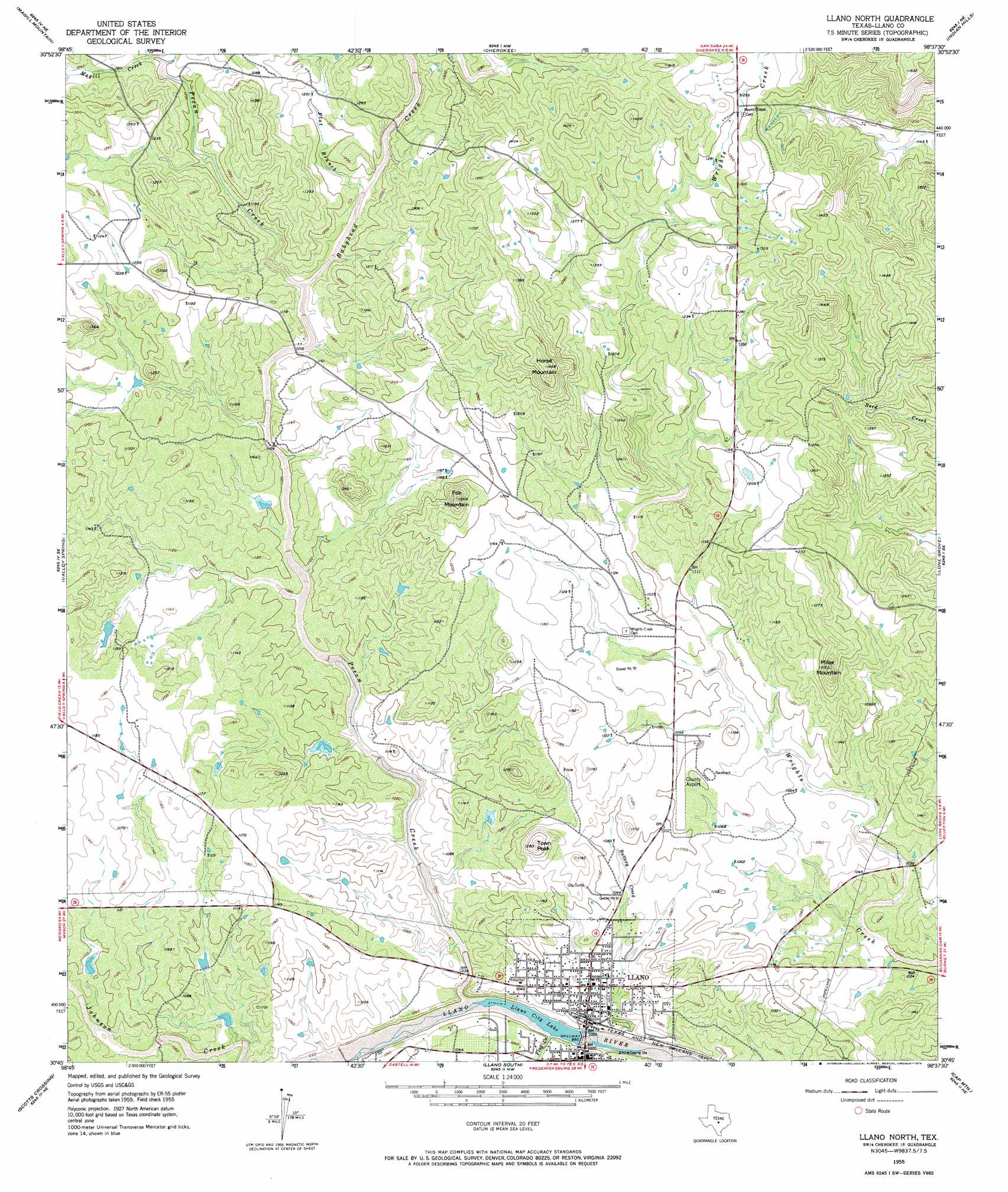
Llano North Topo Map Texas
To zoom in, hover over the map of Llano North
USGS Topo Quad 30098g6 - 1:24,000 scale
| Topo Map Name: | Llano North |
| USGS Topo Quad ID: | 30098g6 |
| Print Size: | ca. 21 1/4" wide x 27" high |
| Southeast Coordinates: | 30.75° N latitude / 98.625° W longitude |
| Map Center Coordinates: | 30.8125° N latitude / 98.6875° W longitude |
| U.S. State: | TX |
| Filename: | o30098g6.jpg |
| Download Map JPG Image: | Llano North topo map 1:24,000 scale |
| Map Type: | Topographic |
| Topo Series: | 7.5´ |
| Map Scale: | 1:24,000 |
| Source of Map Images: | United States Geological Survey (USGS) |
| Alternate Map Versions: |
Llano North TX 1955, updated 1956 Download PDF Buy paper map Llano North TX 1955, updated 1974 Download PDF Buy paper map Llano North TX 2010 Download PDF Buy paper map Llano North TX 2012 Download PDF Buy paper map Llano North TX 2016 Download PDF Buy paper map |
1:24,000 Topo Quads surrounding Llano North
Brady Mountain |
Buffalo Knob |
Bear Hollow |
Bend |
Gorman Falls |
Pontotoc |
Magill Mountain |
Cherokee |
Indian Hills |
Tow |
Smoothingiron Mountain |
Valley Spring |
Llano North |
Lone Grove |
Lake Buchanan |
Castell |
Scotts Crossing |
Llano South |
Cap Mountain |
Kingsland |
House Mountain |
Enchanted Rock |
Oxford |
Click |
Dunman Mountain |
> Back to 30098e1 at 1:100,000 scale
> Back to 30098a1 at 1:250,000 scale
> Back to U.S. Topo Maps home
Llano North topo map: Gazetteer
Llano North: Airports
Llano Municipal Airport elevation 335m 1099′Llano North: Dams
Llano Park Dam elevation 306m 1003′Llano River Dam elevation 300m 984′
Moss Dam 2 elevation 324m 1062′
Llano North: Populated Places
Llano elevation 314m 1030′Llano North: Reservoirs
Llano City Lake elevation 299m 980′Llano Park Lake elevation 306m 1003′
Llano River Lake elevation 300m 984′
Moss Lake 2 elevation 324m 1062′
Llano North: Streams
Babyhead Creek elevation 345m 1131′Buttery Creek elevation 296m 971′
Flag Creek elevation 304m 997′
Flat Branch elevation 354m 1161′
Magill Creek elevation 365m 1197′
Pecan Creek elevation 302m 990′
Llano North: Summits
Fox Mountain elevation 410m 1345′Horse Mountain elevation 442m 1450′
Miller Mountain elevation 400m 1312′
Town Peak elevation 387m 1269′
Llano North digital topo map on disk
Buy this Llano North topo map showing relief, roads, GPS coordinates and other geographical features, as a high-resolution digital map file on DVD: