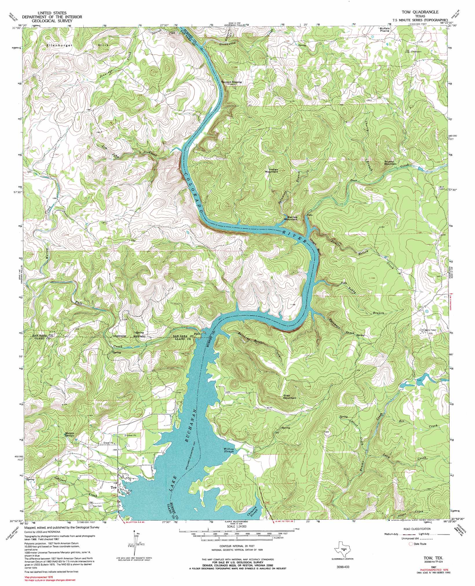
Tow Topo Map Texas
To zoom in, hover over the map of Tow
USGS Topo Quad 30098h4 - 1:24,000 scale
| Topo Map Name: | Tow |
| USGS Topo Quad ID: | 30098h4 |
| Print Size: | ca. 21 1/4" wide x 27" high |
| Southeast Coordinates: | 30.875° N latitude / 98.375° W longitude |
| Map Center Coordinates: | 30.9375° N latitude / 98.4375° W longitude |
| U.S. State: | TX |
| Filename: | o30098h4.jpg |
| Download Map JPG Image: | Tow topo map 1:24,000 scale |
| Map Type: | Topographic |
| Topo Series: | 7.5´ |
| Map Scale: | 1:24,000 |
| Source of Map Images: | United States Geological Survey (USGS) |
| Alternate Map Versions: |
Tow TX 1967, updated 1970 Download PDF Buy paper map Tow TX 1967, updated 1981 Download PDF Buy paper map Tow TX 1967, updated 1992 Download PDF Buy paper map Tow TX 2010 Download PDF Buy paper map Tow TX 2012 Download PDF Buy paper map Tow TX 2016 Download PDF Buy paper map |
1:24,000 Topo Quads surrounding Tow
San Saba |
Wolf Ridge |
Lometa |
Ogles |
Flat Top Peak |
Bear Hollow |
Bend |
Gorman Falls |
Nix |
Lampasas |
Cherokee |
Indian Hills |
Tow |
Naruna |
Lake Victor |
Llano North |
Lone Grove |
Lake Buchanan |
Council Creek |
Burnet |
Llano South |
Cap Mountain |
Kingsland |
Longhorn Cavern |
Mormon Mill |
> Back to 30098e1 at 1:100,000 scale
> Back to 30098a1 at 1:250,000 scale
> Back to U.S. Topo Maps home
Tow topo map: Gazetteer
Tow: Airports
Aero-Bee Ranch Airstrip elevation 388m 1272′Tow: Bays
Chimney Slough elevation 311m 1020′Willow Slough elevation 311m 1020′
Tow: Cliffs
Chism Bluff elevation 311m 1020′Tow: Dams
Indian Dam elevation 396m 1299′Wildcat Dam elevation 393m 1289′
Tow: Flats
Buffalo Prairie elevation 422m 1384′Tow: Populated Places
Tow elevation 316m 1036′Tow: Reservoirs
Indian Lake elevation 396m 1299′Wildcat Lake elevation 393m 1289′
Tow: Springs
Boiling Springs elevation 400m 1312′Falls Creek Spring elevation 368m 1207′
Morgan Springs elevation 372m 1220′
Tow: Streams
Ashby Branch elevation 311m 1020′Bee Creek elevation 369m 1210′
Buzzards Roost Creek elevation 311m 1020′
Calvert Creek elevation 311m 1020′
Cherry Branch elevation 359m 1177′
Deer Creek elevation 313m 1026′
Devils Hollow Creek elevation 311m 1020′
Fall Creek elevation 311m 1020′
Greenwood Creek elevation 317m 1040′
Jim John Creek elevation 315m 1033′
Lacy Creek elevation 333m 1092′
Marley Creek elevation 371m 1217′
Niter Creek elevation 334m 1095′
Simpson Creek elevation 328m 1076′
Sycamore Branch elevation 311m 1020′
Sycamore Creek elevation 311m 1020′
Tow: Summits
Barnes Mountain elevation 409m 1341′Brushy Mountain elevation 451m 1479′
Ellenburger Hills elevation 441m 1446′
Gray Mountain elevation 441m 1446′
Indian Mountain elevation 434m 1423′
Tow: Trails
Canyon of the Eagles Trail elevation 329m 1079′Tow digital topo map on disk
Buy this Tow topo map showing relief, roads, GPS coordinates and other geographical features, as a high-resolution digital map file on DVD: