Bailey Creek Topo Map Texas
To zoom in, hover over the map of Bailey Creek
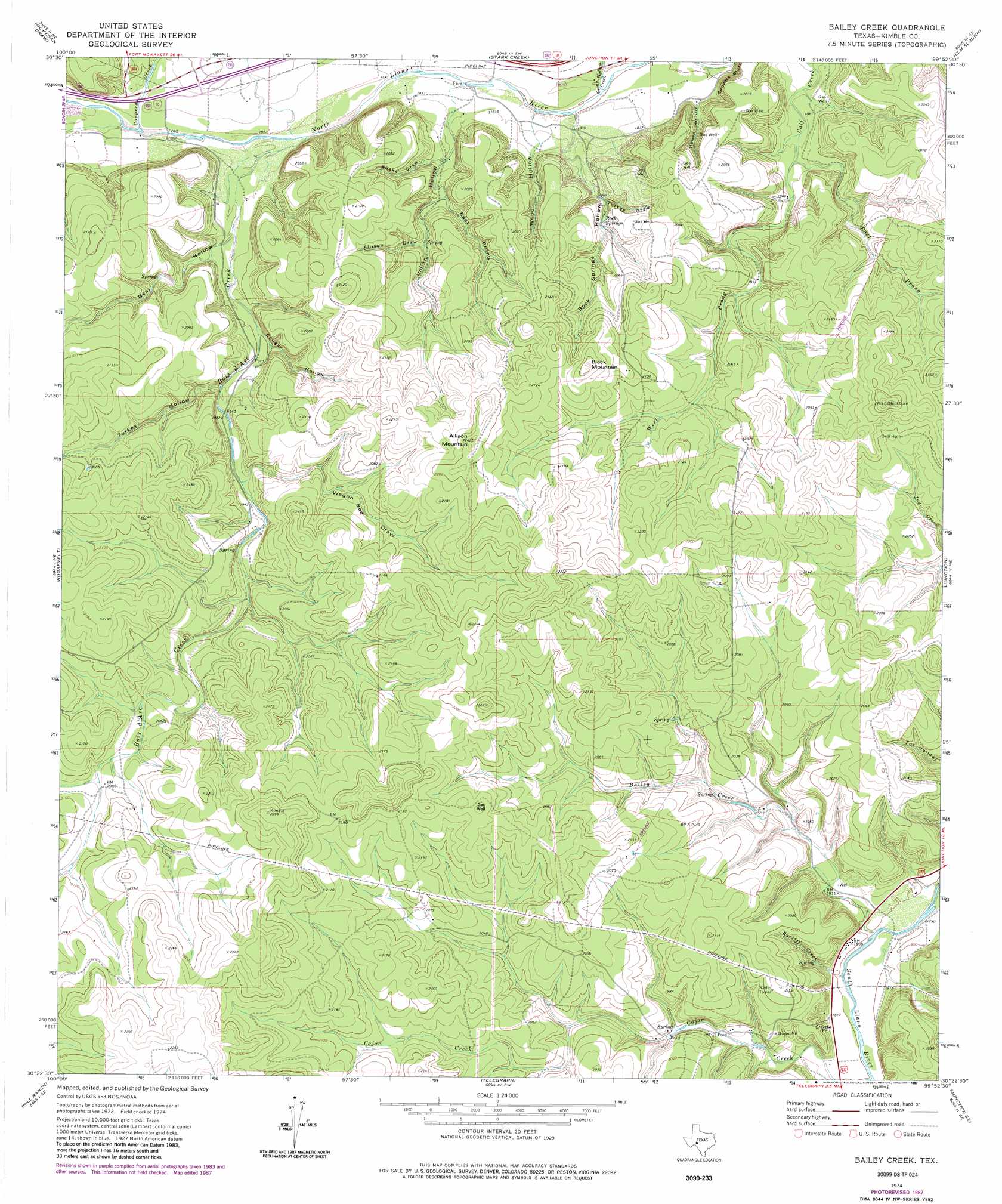
USGS Topo Quad 30099d8 - 1:24,000 scale
| Topo Map Name: | Bailey Creek |
| USGS Topo Quad ID: | 30099d8 |
| Print Size: | ca. 21 1/4" wide x 27" high |
| Southeast Coordinates: | 30.375° N latitude / 99.875° W longitude |
| Map Center Coordinates: | 30.4375° N latitude / 99.9375° W longitude |
| U.S. State: | TX |
| Filename: | o30099d8.jpg |
| Download Map JPG Image: | Bailey Creek topo map 1:24,000 scale |
| Map Type: | Topographic |
| Topo Series: | 7.5´ |
| Map Scale: | 1:24,000 |
| Source of Map Images: | United States Geological Survey (USGS) |
| Alternate Map Versions: |
Bailey Creek TX 1974, updated 1977 Download PDF Buy paper map Bailey Creek TX 1974, updated 1987 Download PDF Buy paper map Bailey Creek TX 2010 Download PDF Buy paper map Bailey Creek TX 2012 Download PDF Buy paper map Bailey Creek TX 2016 Download PDF Buy paper map |
1:24,000 Topo Quads surrounding Bailey Creek
Coal Kiln Draw |
Mckegan Draw Ne |
Rust Ranch |
Julio Draw |
Brewer Hollow |
Brokeleg Mountain |
Mckegan Draw |
Stark Creek |
Elm Slough |
Big Draw |
Fort Terrett Ranch |
Roosevelt |
Bailey Creek |
Junction |
Segovia |
Bundy Ranch |
Hill Ranch |
Telegraph |
Junction Se |
Allen Creek |
Elbow Lake |
Paint Rock Spring |
Bradford Creek |
Horse Camp Waterhole |
Y O Ranch |
> Back to 30099a1 at 1:100,000 scale
> Back to 30098a1 at 1:250,000 scale
> Back to U.S. Topo Maps home
Bailey Creek topo map: Gazetteer
Bailey Creek: Cliffs
Sanders Bluff elevation 577m 1893′Bailey Creek: Springs
Coleman Springs elevation 607m 1991′Rock Springs elevation 583m 1912′
Bailey Creek: Streams
Bailey Creek elevation 541m 1774′Bois d'Arc Creek elevation 555m 1820′
Cajac Creek elevation 548m 1797′
Cedar Hollow Creek elevation 548m 1797′
Copperas Creek elevation 559m 1833′
East Prong Calf Creek elevation 567m 1860′
Ratliff Creek elevation 542m 1778′
Stark Creek elevation 554m 1817′
West Prong Calf Creek elevation 567m 1860′
Bailey Creek: Summits
Allison Mountain elevation 682m 2237′Black Mountain elevation 683m 2240′
Bailey Creek: Valleys
Allison Draw elevation 586m 1922′Bear Hollow elevation 567m 1860′
Cougar Hollow elevation 577m 1893′
East Prong Indian Hollow elevation 575m 1886′
House Hollow elevation 555m 1820′
Indian Hollow elevation 557m 1827′
Rock Springs Hollow elevation 554m 1817′
Snake Draw elevation 565m 1853′
Turkey Draw elevation 572m 1876′
Turkey Hollow elevation 577m 1893′
Wagon Bed Draw elevation 588m 1929′
Wood Hollow elevation 554m 1817′
Bailey Creek digital topo map on disk
Buy this Bailey Creek topo map showing relief, roads, GPS coordinates and other geographical features, as a high-resolution digital map file on DVD: