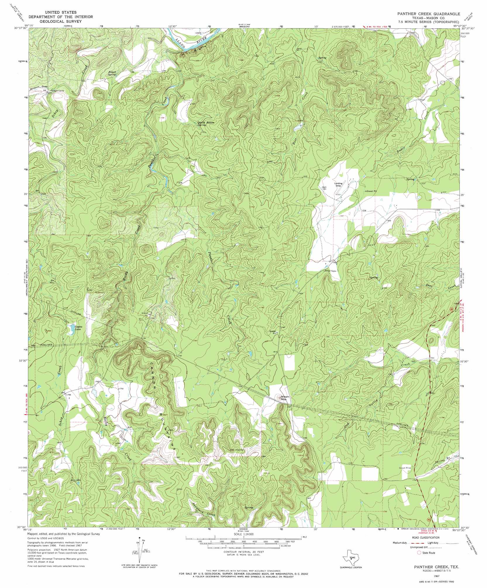
Panther Creek Topo Map Texas
To zoom in, hover over the map of Panther Creek
USGS Topo Quad 30099e2 - 1:24,000 scale
| Topo Map Name: | Panther Creek |
| USGS Topo Quad ID: | 30099e2 |
| Print Size: | ca. 21 1/4" wide x 27" high |
| Southeast Coordinates: | 30.5° N latitude / 99.125° W longitude |
| Map Center Coordinates: | 30.5625° N latitude / 99.1875° W longitude |
| U.S. State: | TX |
| Filename: | o30099e2.jpg |
| Download Map JPG Image: | Panther Creek topo map 1:24,000 scale |
| Map Type: | Topographic |
| Topo Series: | 7.5´ |
| Map Scale: | 1:24,000 |
| Source of Map Images: | United States Geological Survey (USGS) |
| Alternate Map Versions: |
Panther Creek TX 1967, updated 1969 Download PDF Buy paper map Panther Creek TX 1967, updated 1970 Download PDF Buy paper map Panther Creek TX 2010 Download PDF Buy paper map Panther Creek TX 2012 Download PDF Buy paper map Panther Creek TX 2016 Download PDF Buy paper map |
1:24,000 Topo Quads surrounding Panther Creek
Long Mountain |
Grit |
Purdy Hill |
Fly Gap |
Smoothingiron Mountain |
Sheep Run Creek |
Turtle Creek |
Mason |
Art |
Castell |
Monument Mountain |
Monument Mountain Se |
Panther Creek |
Loyal Valley |
House Mountain |
Noxville |
The Falls |
Doss |
Cherry Spring |
Cherry Mountain |
Old Noxville |
Harper West |
Harper East |
Roundhead |
Fredericksburg West |
> Back to 30099e1 at 1:100,000 scale
> Back to 30098a1 at 1:250,000 scale
> Back to U.S. Topo Maps home
Panther Creek topo map: Gazetteer
Panther Creek: Cliffs
H L Bluffs elevation 407m 1335′Panther Creek: Ranges
Cannon Mountains elevation 619m 2030′Panther Creek: Reservoirs
Coyote Lake elevation 525m 1722′Panther Creek: Springs
Anderegg Spring elevation 519m 1702′Eckert Spring elevation 416m 1364′
Quella Bottom Spring elevation 446m 1463′
Panther Creek: Streams
Panther Creek elevation 394m 1292′Rocky Creek elevation 443m 1453′
Schep Creek elevation 393m 1289′
Panther Creek: Summits
Nixon Mountain elevation 574m 1883′Panther Creek: Valleys
Windmill Draw elevation 432m 1417′Panther Creek digital topo map on disk
Buy this Panther Creek topo map showing relief, roads, GPS coordinates and other geographical features, as a high-resolution digital map file on DVD: