Turtle Creek Topo Map Texas
To zoom in, hover over the map of Turtle Creek
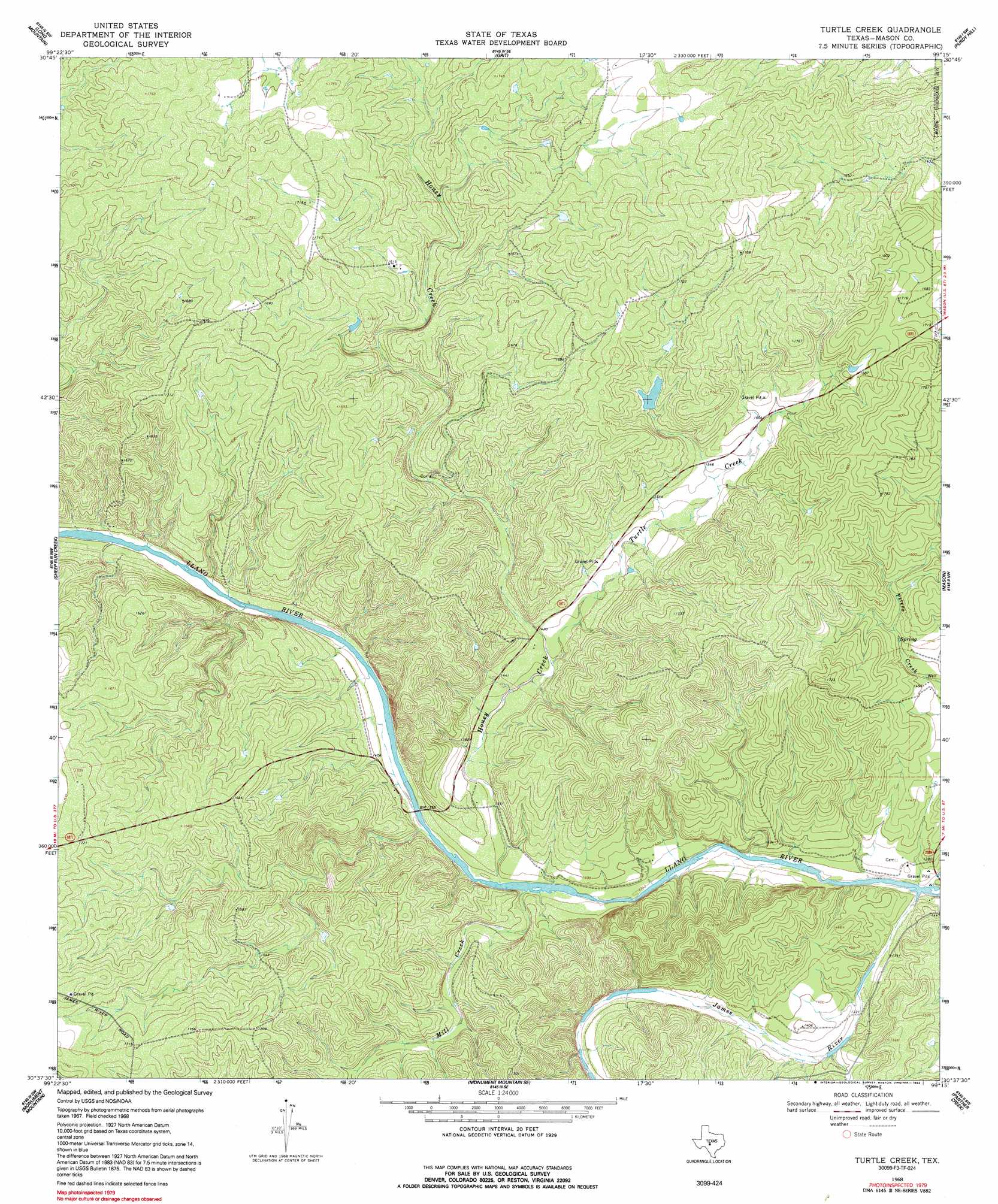
USGS Topo Quad 30099f3 - 1:24,000 scale
| Topo Map Name: | Turtle Creek |
| USGS Topo Quad ID: | 30099f3 |
| Print Size: | ca. 21 1/4" wide x 27" high |
| Southeast Coordinates: | 30.625° N latitude / 99.25° W longitude |
| Map Center Coordinates: | 30.6875° N latitude / 99.3125° W longitude |
| U.S. State: | TX |
| Filename: | o30099f3.jpg |
| Download Map JPG Image: | Turtle Creek topo map 1:24,000 scale |
| Map Type: | Topographic |
| Topo Series: | 7.5´ |
| Map Scale: | 1:24,000 |
| Source of Map Images: | United States Geological Survey (USGS) |
| Alternate Map Versions: |
Turtle Creek TX 1968, updated 1970 Download PDF Buy paper map Turtle Creek TX 1968, updated 1992 Download PDF Buy paper map Turtle Creek TX 2010 Download PDF Buy paper map Turtle Creek TX 2012 Download PDF Buy paper map Turtle Creek TX 2016 Download PDF Buy paper map |
1:24,000 Topo Quads surrounding Turtle Creek
Robbers Roost |
Calf Creek |
Katemcy |
Spy Rock |
Fredonia |
Hext |
Long Mountain |
Grit |
Purdy Hill |
Fly Gap |
London |
Sheep Run Creek |
Turtle Creek |
Mason |
Art |
Yates |
Monument Mountain |
Monument Mountain Se |
Panther Creek |
Loyal Valley |
Tobe Branch |
Noxville |
The Falls |
Doss |
Cherry Spring |
> Back to 30099e1 at 1:100,000 scale
> Back to 30098a1 at 1:250,000 scale
> Back to U.S. Topo Maps home
Turtle Creek topo map: Gazetteer
Turtle Creek: Dams
Zesch Lake Dam elevation 489m 1604′Turtle Creek: Reservoirs
Zesch Lake elevation 489m 1604′Turtle Creek: Springs
Kothmann Springs elevation 495m 1624′Mill Springs elevation 415m 1361′
Turtle Creek: Streams
Honey Creek elevation 411m 1348′James River elevation 402m 1318′
Mill Creek elevation 410m 1345′
Peters Creek elevation 446m 1463′
Turtle Creek elevation 434m 1423′
Turtle Creek digital topo map on disk
Buy this Turtle Creek topo map showing relief, roads, GPS coordinates and other geographical features, as a high-resolution digital map file on DVD: