Tesnus Topo Map Texas
To zoom in, hover over the map of Tesnus
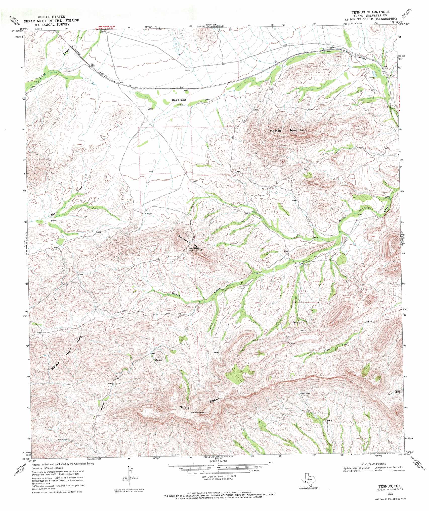
USGS Topo Quad 30102a8 - 1:24,000 scale
| Topo Map Name: | Tesnus |
| USGS Topo Quad ID: | 30102a8 |
| Print Size: | ca. 21 1/4" wide x 27" high |
| Southeast Coordinates: | 30° N latitude / 102.875° W longitude |
| Map Center Coordinates: | 30.0625° N latitude / 102.9375° W longitude |
| U.S. State: | TX |
| Filename: | o30102a8.jpg |
| Download Map JPG Image: | Tesnus topo map 1:24,000 scale |
| Map Type: | Topographic |
| Topo Series: | 7.5´ |
| Map Scale: | 1:24,000 |
| Source of Map Images: | United States Geological Survey (USGS) |
| Alternate Map Versions: |
Tesnus TX 1968, updated 1971 Download PDF Buy paper map Tesnus TX 1968, updated 1971 Download PDF Buy paper map Tesnus TX 2010 Download PDF Buy paper map Tesnus TX 2012 Download PDF Buy paper map Tesnus TX 2016 Download PDF Buy paper map |
1:24,000 Topo Quads surrounding Tesnus
Leonard Mountain |
Wolf Camp Hills |
Dimple Hills |
Cap Rock Butte |
F C Ranch |
Marathon |
Lightening Hills |
Housetop Mountains |
Tesnus Ne |
Longfellow |
Pena Blanca Mountains |
Horse Mountain |
Tesnus |
Tesnus Se |
Fresno Creek |
Heart Mountain |
Hood Spring |
Pine Mountain West |
Pine Mountain East |
San Francisco Shutups |
Sosa Peak |
Hood Spring Se |
Yellow House Peak |
Dove Mountain |
Beef Gap |
> Back to 30102a1 at 1:100,000 scale
> Back to 30102a1 at 1:250,000 scale
> Back to U.S. Topo Maps home
Tesnus topo map: Gazetteer
Tesnus: Basins
Copeland Trap elevation 1163m 3815′Tesnus: Gaps
Panther Gap elevation 1272m 4173′Tesnus: Populated Places
Tesnus elevation 1136m 3727′Tesnus: Summits
Castle Mountain elevation 1369m 4491′Panther Peaks elevation 1375m 4511′
Shely Peaks elevation 1584m 5196′
Tesnus digital topo map on disk
Buy this Tesnus topo map showing relief, roads, GPS coordinates and other geographical features, as a high-resolution digital map file on DVD: