Fort Stockton West Topo Map Texas
To zoom in, hover over the map of Fort Stockton West
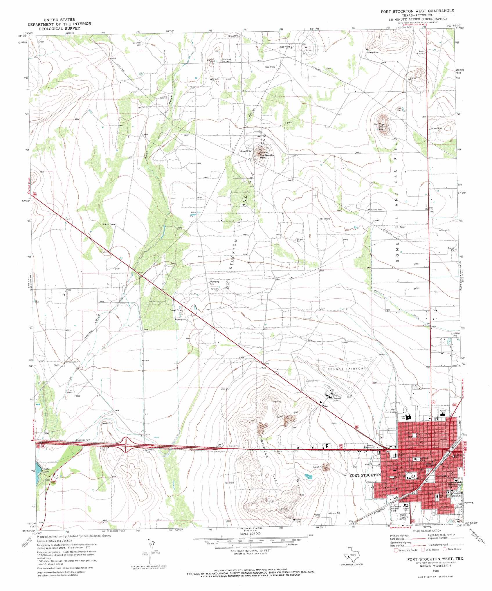
USGS Topo Quad 30102h8 - 1:24,000 scale
| Topo Map Name: | Fort Stockton West |
| USGS Topo Quad ID: | 30102h8 |
| Print Size: | ca. 21 1/4" wide x 27" high |
| Southeast Coordinates: | 30.875° N latitude / 102.875° W longitude |
| Map Center Coordinates: | 30.9375° N latitude / 102.9375° W longitude |
| U.S. State: | TX |
| Filename: | o30102h8.jpg |
| Download Map JPG Image: | Fort Stockton West topo map 1:24,000 scale |
| Map Type: | Topographic |
| Topo Series: | 7.5´ |
| Map Scale: | 1:24,000 |
| Source of Map Images: | United States Geological Survey (USGS) |
| Alternate Map Versions: |
Fort Stockton West TX 1970, updated 1973 Download PDF Buy paper map Fort Stockton West TX 2010 Download PDF Buy paper map Fort Stockton West TX 2012 Download PDF Buy paper map Fort Stockton West TX 2016 Download PDF Buy paper map |
1:24,000 Topo Quads surrounding Fort Stockton West
Coyanosa Nw |
Coyanosa |
Diamond Y Spring Nw |
Diamond Y Spring Ne |
Buena Vista |
Coyanosa Sw |
Coyanosa Se |
Diamond Y Spring |
Diamond Y Spring Se |
Buena Vista Sw |
Belding Nw |
Belding Ne |
Fort Stockton West |
Fort Stockton East |
East Mesa |
Belding Sw |
Belding |
Twelvemile Mesa |
Fivemile Mesa |
East Mesa Sw |
Chancellor |
Cave Mesa Ne |
Sierra Madera Nw |
Sierra Madera Ne |
Rock House Draw Nw |
> Back to 30102e1 at 1:100,000 scale
> Back to 30102a1 at 1:250,000 scale
> Back to U.S. Topo Maps home
Fort Stockton West topo map: Gazetteer
Fort Stockton West: Airports
Fort Stockton-Pecos County Airport elevation 912m 2992′Fort Stockton West: Canals
Highline Ditch elevation 889m 2916′Fort Stockton West: Oilfields
Fort Stockton Oil and Gas Field elevation 890m 2919′Gomez Oil and Gas Field elevation 876m 2874′
Fort Stockton West: Parks
Fort Stockton City Park elevation 908m 2979′James Rooney Memorial Park elevation 895m 2936′
Lannom Park elevation 911m 2988′
Panther Stadium elevation 907m 2975′
Pat Taylor Athletic Field elevation 920m 3018′
Fort Stockton West: Populated Places
Fort Stockton elevation 906m 2972′Guild elevation 875m 2870′
Little Mexico Colonia elevation 893m 2929′
Fort Stockton West: Springs
Comanche Springs elevation 896m 2939′Comanche Springs (historical) elevation 903m 2962′
Fort Stockton West: Summits
Flat Top elevation 902m 2959′Sevenmile Mesa elevation 887m 2910′
The Needle Point elevation 908m 2979′
Twomile Hill elevation 961m 3152′
Fort Stockton West digital topo map on disk
Buy this Fort Stockton West topo map showing relief, roads, GPS coordinates and other geographical features, as a high-resolution digital map file on DVD: