Balmorhea Topo Map Texas
To zoom in, hover over the map of Balmorhea
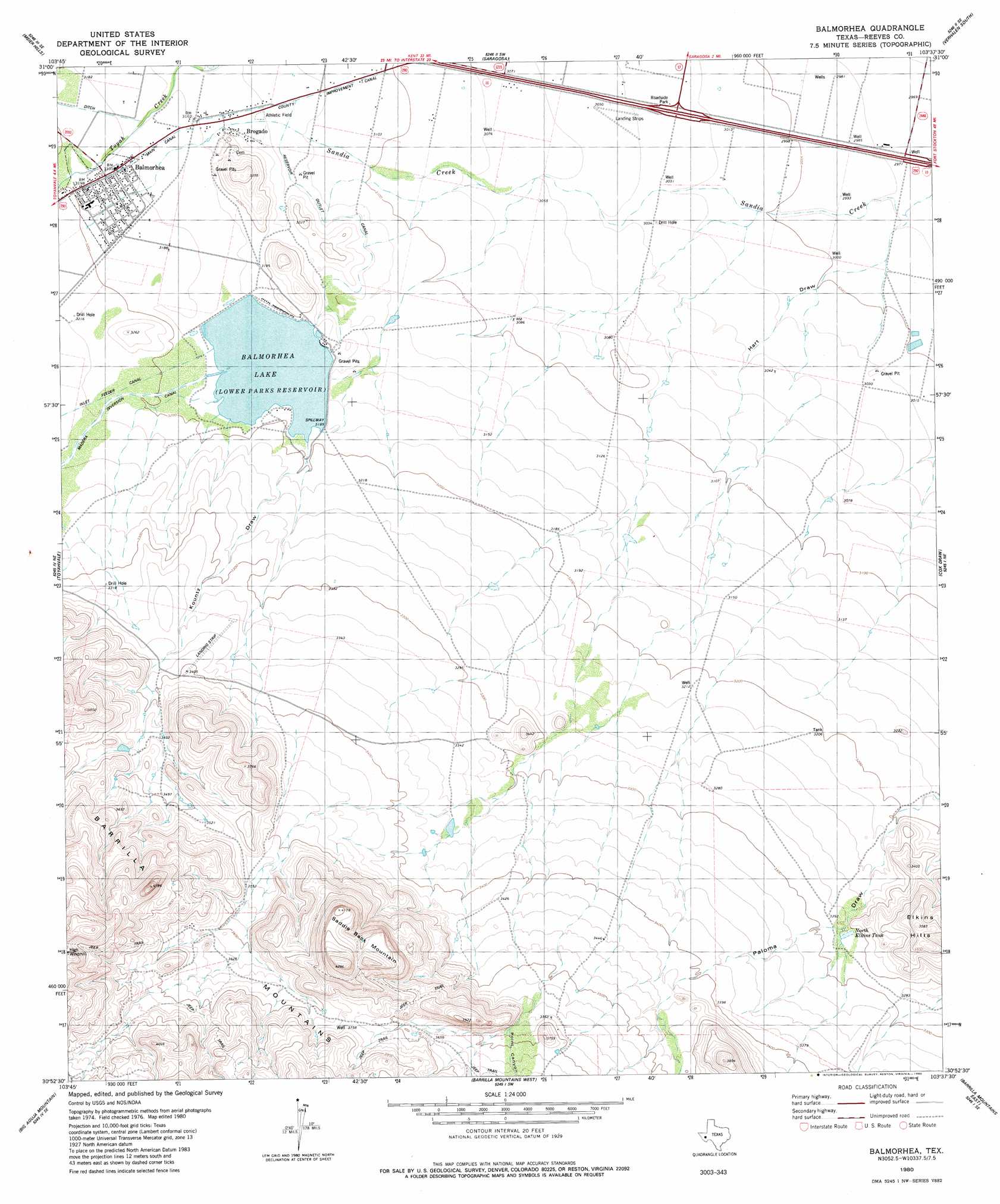
USGS Topo Quad 30103h6 - 1:24,000 scale
| Topo Map Name: | Balmorhea |
| USGS Topo Quad ID: | 30103h6 |
| Print Size: | ca. 21 1/4" wide x 27" high |
| Southeast Coordinates: | 30.875° N latitude / 103.625° W longitude |
| Map Center Coordinates: | 30.9375° N latitude / 103.6875° W longitude |
| U.S. State: | TX |
| Filename: | o30103h6.jpg |
| Download Map JPG Image: | Balmorhea topo map 1:24,000 scale |
| Map Type: | Topographic |
| Topo Series: | 7.5´ |
| Map Scale: | 1:24,000 |
| Source of Map Images: | United States Geological Survey (USGS) |
| Alternate Map Versions: |
Balmorhea TX 1980, updated 1980 Download PDF Buy paper map Balmorhea TX 2010 Download PDF Buy paper map Balmorhea TX 2012 Download PDF Buy paper map Balmorhea TX 2016 Download PDF Buy paper map |
1:24,000 Topo Quads surrounding Balmorhea
Gozar |
Florenzo Hill |
Saragosa Nw |
Verhalen North |
Barstow 3 Nw |
Sotol Hill |
Meier Hills |
Saragosa |
Verhalen South |
Barstow 3 Sw |
Antelope Flat |
Toyahvale |
Balmorhea |
Cox Draw |
Deep Well Ranch Nw |
Little Aguja Mountain |
Big Aguja Mountain |
Barrilla Mountains West |
Barrilla Mountains East |
Deep Well Ranch |
Casket Mountain |
Swayback Mountain |
Major Peak |
Little Star Mountain |
Leoncita Ranch |
> Back to 30103e1 at 1:100,000 scale
> Back to 30102a1 at 1:250,000 scale
> Back to U.S. Topo Maps home
Balmorhea topo map: Gazetteer
Balmorhea: Airports
Saddleback Ranch Number 2 Airport elevation 1110m 3641′Balmorhea: Canals
Reservoir Outlet Canal elevation 955m 3133′Balmorhea: Dams
Balmorhea Lake Dam elevation 944m 3097′Balmorhea: Populated Places
Balmorhea elevation 974m 3195′Balmorhea: Reservoirs
Balmorhea Lake elevation 971m 3185′Lake Balmorhea elevation 944m 3097′
North Elkins Tank elevation 1001m 3284′
Balmorhea: Springs
Sandia Springs elevation 971m 3185′Balmorhea: Summits
Saddle Back Mountains elevation 1270m 4166′Balmorhea: Valleys
Hart Draw elevation 908m 2979′Kountz Draw elevation 975m 3198′
Point Canyon elevation 1090m 3576′
Balmorhea digital topo map on disk
Buy this Balmorhea topo map showing relief, roads, GPS coordinates and other geographical features, as a high-resolution digital map file on DVD: