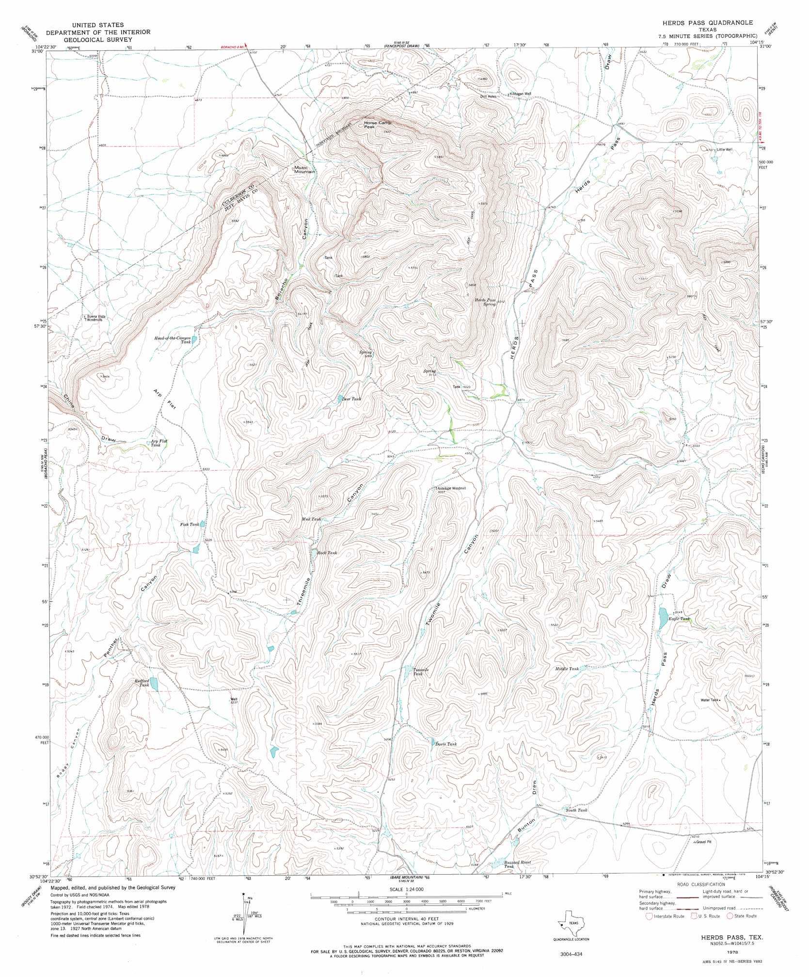
Herds Pass Topo Map Texas
To zoom in, hover over the map of Herds Pass
USGS Topo Quad 30104h3 - 1:24,000 scale
| Topo Map Name: | Herds Pass |
| USGS Topo Quad ID: | 30104h3 |
| Print Size: | ca. 21 1/4" wide x 27" high |
| Southeast Coordinates: | 30.875° N latitude / 104.25° W longitude |
| Map Center Coordinates: | 30.9375° N latitude / 104.3125° W longitude |
| U.S. State: | TX |
| Filename: | o30104h3.jpg |
| Download Map JPG Image: | Herds Pass topo map 1:24,000 scale |
| Map Type: | Topographic |
| Topo Series: | 7.5´ |
| Map Scale: | 1:24,000 |
| Source of Map Images: | United States Geological Survey (USGS) |
| Alternate Map Versions: |
Herds Pass TX 1978, updated 1978 Download PDF Buy paper map Herds Pass TX 2010 Download PDF Buy paper map Herds Pass TX 2012 Download PDF Buy paper map Herds Pass TX 2016 Download PDF Buy paper map |
1:24,000 Topo Quads surrounding Herds Pass
Goat Canyon |
East Hunter Canyon |
Panther Canyon |
Iron Mountain |
San Martine |
Plateau |
Boracho |
Fencepost Draw |
Kent |
Gomez Peak |
Chispa Mountain Ne |
Boracho Peak |
Herds Pass |
Echo Canyon |
Buckhorn Mountain |
Mayfield Hills |
Boggy Draw |
Bare Mountain |
Robbers Roost Canyon |
Friend Mountain |
Dowman Canyon |
Horseshoe Butte |
El Muerto Peak |
Mount Livermore |
Mount Locke |
> Back to 30104e1 at 1:100,000 scale
> Back to 30104a1 at 1:250,000 scale
> Back to U.S. Topo Maps home
Herds Pass topo map: Gazetteer
Herds Pass: Flats
Arp Flat elevation 1603m 5259′Herds Pass: Reservoirs
Arp Flat Tank elevation 1596m 5236′Buzzard Roost Tank elevation 1579m 5180′
Davis Tank elevation 1597m 5239′
Deer Tank elevation 1642m 5387′
Eagle Tank elevation 1570m 5150′
Fish Tank elevation 1599m 5246′
Head- of- the-Canyon Tank elevation 1589m 5213′
Middle Tank elevation 1610m 5282′
Mud Tank elevation 1570m 5150′
Redford Tank elevation 1570m 5150′
Rock Tank elevation 1583m 5193′
South Tank elevation 1609m 5278′
Twomile Tank elevation 1570m 5150′
Herds Pass: Springs
Herds Pass Spring elevation 1522m 4993′Herds Pass: Summits
Horse Camp Peak elevation 1771m 5810′Music Mountain elevation 1522m 4993′
Herds Pass: Valleys
Boracho Canyon elevation 1462m 4796′Herds Pass elevation 1426m 4678′
Threemile Canyon elevation 1535m 5036′
Twomile Canyon elevation 1496m 4908′
Herds Pass: Wells
Kildugan Well elevation 1437m 4714′Little Well elevation 1437m 4714′
Herds Pass digital topo map on disk
Buy this Herds Pass topo map showing relief, roads, GPS coordinates and other geographical features, as a high-resolution digital map file on DVD: