Eagle Mountains Ne Topo Map Texas
To zoom in, hover over the map of Eagle Mountains Ne
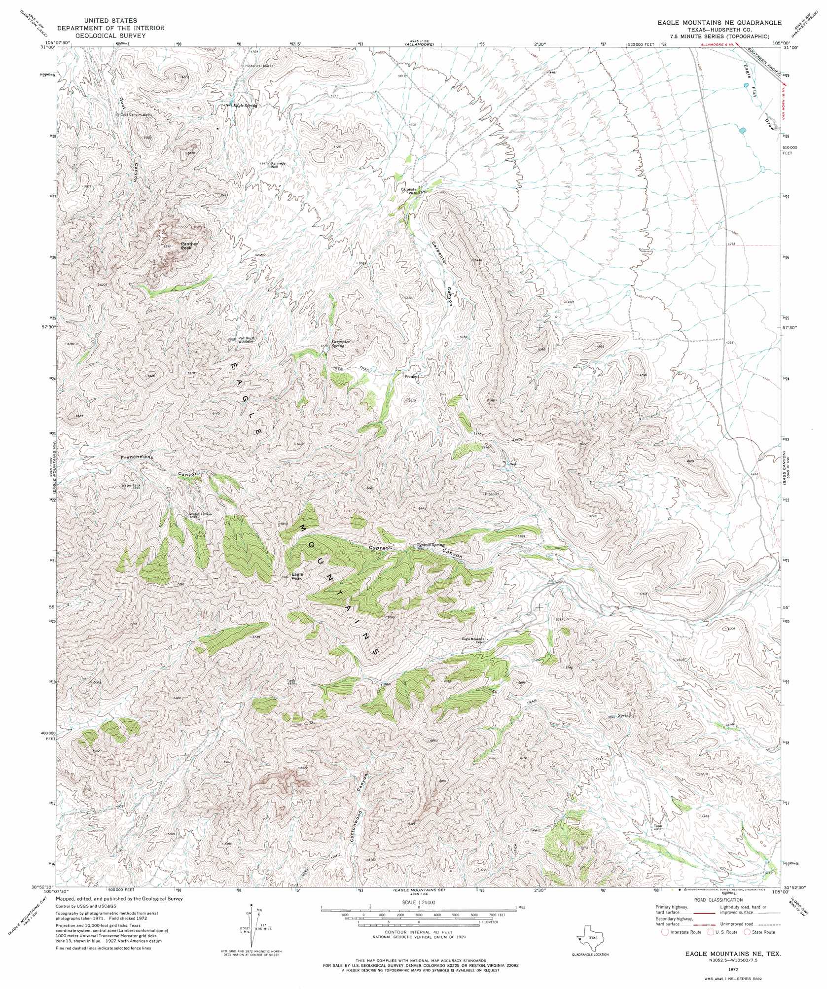
USGS Topo Quad 30105h1 - 1:24,000 scale
| Topo Map Name: | Eagle Mountains Ne |
| USGS Topo Quad ID: | 30105h1 |
| Print Size: | ca. 21 1/4" wide x 27" high |
| Southeast Coordinates: | 30.875° N latitude / 105° W longitude |
| Map Center Coordinates: | 30.9375° N latitude / 105.0625° W longitude |
| U.S. State: | TX |
| Filename: | o30105h1.jpg |
| Download Map JPG Image: | Eagle Mountains Ne topo map 1:24,000 scale |
| Map Type: | Topographic |
| Topo Series: | 7.5´ |
| Map Scale: | 1:24,000 |
| Source of Map Images: | United States Geological Survey (USGS) |
| Alternate Map Versions: |
Eagle Mountains NE TX 1972, updated 1975 Download PDF Buy paper map Eagle Mountains NE TX 2010 Download PDF Buy paper map Eagle Mountains NE TX 2012 Download PDF Buy paper map Eagle Mountains NE TX 2016 Download PDF Buy paper map |
1:24,000 Topo Quads surrounding Eagle Mountains Ne
Sierra Blanca |
Dome Peak |
Bean Hills |
Sheep Peak |
Nutt Ranch |
Devil Ridge |
Grayton Lake |
Allamoore |
Hackett Peak |
Van Horn |
Cedar Arroyo |
Eagle Mountains Nw |
Eagle Mountains Ne |
Bass Canyon |
Van Horn Wells |
Indian Hot Springs |
Eagle Mountains Sw |
Eagle Mountains Se |
Lobo Sw |
Lobo |
Bramlett Ranch |
Mesquite Spring |
Ninetysix Ranch |
> Back to 30105e1 at 1:100,000 scale
> Back to 30104a1 at 1:250,000 scale
> Back to U.S. Topo Maps home
Eagle Mountains Ne topo map: Gazetteer
Eagle Mountains Ne: Ranges
Eagle Mountains elevation 2070m 6791′Eagle Mountains Ne: Springs
Carpenter Spring elevation 1579m 5180′Cypress Spring elevation 1756m 5761′
Eagle Spring elevation 1509m 4950′
Eagle Spring elevation 1452m 4763′
Eagle Mountains Ne: Summits
Eagle Peak elevation 2274m 7460′Panther Peak elevation 1929m 6328′
Eagle Mountains Ne: Valleys
Carpenter Canyon elevation 1451m 4760′Cypress Canyon elevation 1553m 5095′
Eagle Mountains Ne: Wells
Carpenter Wells elevation 1449m 4753′Goat Canyon Wells elevation 1558m 5111′
Kennedy Well elevation 1502m 4927′
Eagle Mountains Ne digital topo map on disk
Buy this Eagle Mountains Ne topo map showing relief, roads, GPS coordinates and other geographical features, as a high-resolution digital map file on DVD: