Dover Bluff Topo Map Georgia
To zoom in, hover over the map of Dover Bluff
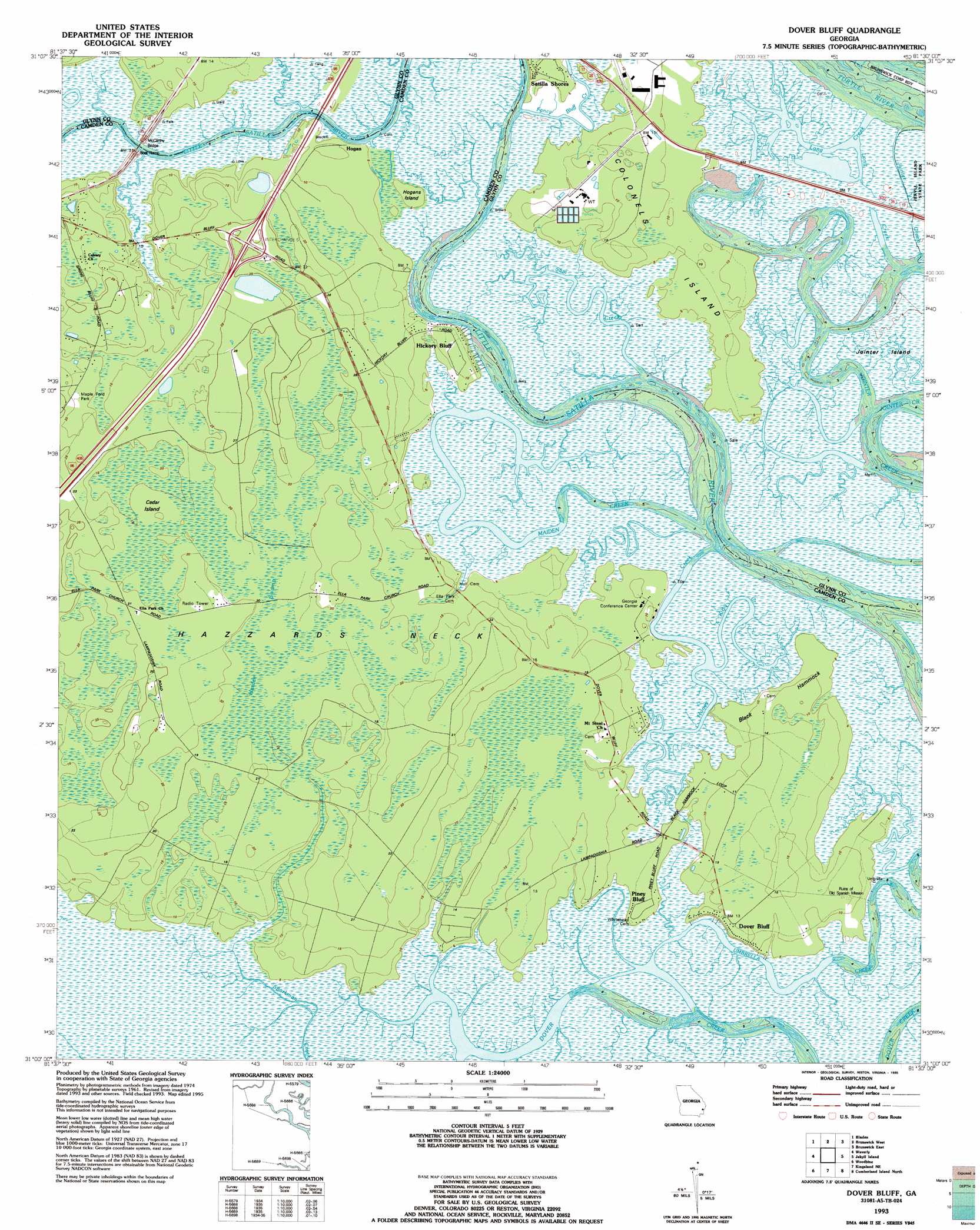
USGS Topo Quad 31081a5 - 1:24,000 scale
| Topo Map Name: | Dover Bluff |
| USGS Topo Quad ID: | 31081a5 |
| Print Size: | ca. 21 1/4" wide x 27" high |
| Southeast Coordinates: | 31° N latitude / 81.5° W longitude |
| Map Center Coordinates: | 31.0625° N latitude / 81.5625° W longitude |
| U.S. State: | GA |
| Filename: | o31081a5.jpg |
| Download Map JPG Image: | Dover Bluff topo map 1:24,000 scale |
| Map Type: | Topographic |
| Topo Series: | 7.5´ |
| Map Scale: | 1:24,000 |
| Source of Map Images: | United States Geological Survey (USGS) |
| Alternate Map Versions: |
Dover Bluff GA 1961, updated 1963 Download PDF Buy paper map Dover Bluff GA 1979, updated 1980 Download PDF Buy paper map Dover Bluff GA 1979, updated 1988 Download PDF Buy paper map Dover Bluff GA 1993, updated 1995 Download PDF Buy paper map Dover Bluff GA 2011 Download PDF Buy paper map Dover Bluff GA 2014 Download PDF Buy paper map |
1:24,000 Topo Quads surrounding Dover Bluff
Browntown |
Thalmann |
Sterling |
Darien |
Altamaha Sound |
Waynesville |
Bladen |
Brunswick West |
Brunswick East |
Sea Island |
Tarboro |
Waverly |
Dover Bluff |
Jekyll Island |
|
Jerusalem |
Woodbine |
Kingsland Ne |
Cumberland Island North |
|
Kings Ferry |
Kingsland |
Harrietts Bluff |
Cumberland Island South |
> Back to 31081a1 at 1:100,000 scale
> Back to 31080a1 at 1:250,000 scale
> Back to U.S. Topo Maps home
Dover Bluff topo map: Gazetteer
Dover Bluff: Bridges
McCarthy Bridge elevation 0m 0′Dover Bluff: Capes
Hazzards Neck elevation 5m 16′Noddings Point elevation 1m 3′
Dover Bluff: Crossings
Exit 5 elevation 7m 22′Dover Bluff: Islands
Black Hammock elevation 3m 9′Cedar Island elevation 3m 9′
Colonels Island elevation 3m 9′
Hogans Island elevation 1m 3′
Hogans Little Island elevation 0m 0′
Jointer Island elevation 0m 0′
Dover Bluff: Populated Places
Dover Bluff elevation 3m 9′Ella Park (historical) elevation 3m 9′
Hickory Bluff elevation 2m 6′
Hogan elevation 1m 3′
Lampadocia (historical) elevation 5m 16′
Piney Bluff elevation 1m 3′
Satilla Shores elevation 3m 9′
Dover Bluff: Streams
Honey Creek elevation 0m 0′Kirby Creek elevation 0m 0′
Long Creek elevation 0m 0′
Maiden Creek elevation 0m 0′
Sam Creek elevation 0m 0′
Dover Bluff: Swamps
Hardee Swamp elevation 5m 16′Dover Bluff digital topo map on disk
Buy this Dover Bluff topo map showing relief, roads, GPS coordinates and other geographical features, as a high-resolution digital map file on DVD: