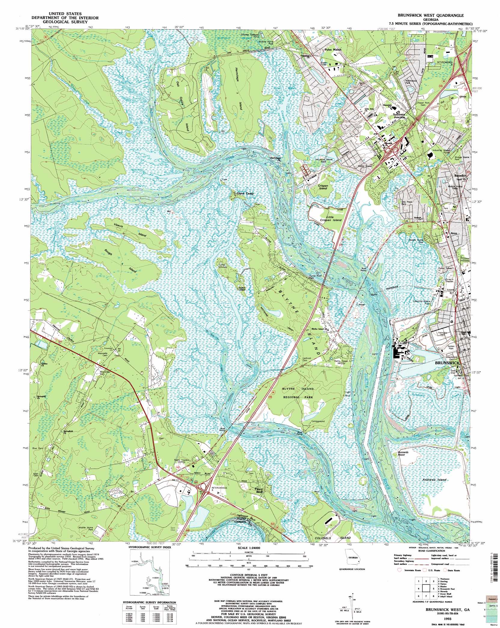
Brunswick West Topo Map Georgia
To zoom in, hover over the map of Brunswick West
USGS Topo Quad 31081b5 - 1:24,000 scale
| Topo Map Name: | Brunswick West |
| USGS Topo Quad ID: | 31081b5 |
| Print Size: | ca. 21 1/4" wide x 27" high |
| Southeast Coordinates: | 31.125° N latitude / 81.5° W longitude |
| Map Center Coordinates: | 31.1875° N latitude / 81.5625° W longitude |
| U.S. State: | GA |
| Filename: | o31081b5.jpg |
| Download Map JPG Image: | Brunswick West topo map 1:24,000 scale |
| Map Type: | Topographic |
| Topo Series: | 7.5´ |
| Map Scale: | 1:24,000 |
| Source of Map Images: | United States Geological Survey (USGS) |
| Alternate Map Versions: |
Brunswick West GA 1956, updated 1960 Download PDF Buy paper map Brunswick West GA 1956, updated 1976 Download PDF Buy paper map Brunswick West GA 1979, updated 1980 Download PDF Buy paper map Brunswick West GA 1979, updated 1988 Download PDF Buy paper map Brunswick West GA 1993, updated 1995 Download PDF Buy paper map Brunswick West GA 2011 Download PDF Buy paper map Brunswick West GA 2014 Download PDF Buy paper map |
1:24,000 Topo Quads surrounding Brunswick West
Manningtown |
Everett |
Cox |
Ridgeville |
Doboy Sound |
Browntown |
Thalmann |
Sterling |
Darien |
Altamaha Sound |
Waynesville |
Bladen |
Brunswick West |
Brunswick East |
Sea Island |
Tarboro |
Waverly |
Dover Bluff |
Jekyll Island |
|
Jerusalem |
Woodbine |
Kingsland Ne |
Cumberland Island North |
> Back to 31081a1 at 1:100,000 scale
> Back to 31080a1 at 1:250,000 scale
> Back to U.S. Topo Maps home
Brunswick West topo map: Gazetteer
Brunswick West: Bridges
Joseph B Mercer Bridge elevation 0m 0′Brunswick West: Capes
Hermitage Point elevation 0m 0′Brunswick West: Channels
Fancy Bluff Creek elevation 1m 3′Gibson Creek elevation 0m 0′
Hillery Creek elevation 0m 0′
Hillery Slough elevation 0m 0′
Morrison Slough elevation 0m 0′
South Brunswick River elevation 0m 0′
Brunswick West: Cliffs
Halfmoon Bluff elevation 3m 9′Brunswick West: Crossings
Exit 6 elevation 5m 16′Exit 7 elevation 7m 22′
Exit 8 elevation 11m 36′
Brunswick West: Islands
Andrews Island elevation 1m 3′Bird Island elevation 1m 3′
Blythe Island elevation 3m 9′
Crispen Island elevation 1m 3′
Hermitage Island elevation 3m 9′
Little Crispen Island elevation 1m 3′
Maggie Hummocks elevation 1m 3′
Oak Grove Island elevation 3m 9′
Rough Island elevation 2m 6′
Visavis Island elevation 3m 9′
Brunswick West: Parks
Arco Park elevation 4m 13′Ballard Park elevation 4m 13′
Blythe Island County Park elevation 3m 9′
Blythe Island Park elevation 3m 9′
Fancy Bluff Park elevation 3m 9′
Seldon Park elevation 3m 9′
Turtle River Park elevation 3m 9′
Brunswick West: Populated Places
Arco elevation 4m 13′Atlantic Village Mobile Home Park elevation 3m 9′
Benedict elevation 5m 16′
Blythe Island elevation 3m 9′
Clover Heights elevation 5m 16′
Cox elevation 4m 13′
Deerwood elevation 3m 9′
Dock Junction elevation 1m 3′
Driftwood Mobile Home Park elevation 6m 19′
Ellis Point elevation 2m 6′
Fancy Bluff elevation 3m 9′
Glendale Gardens elevation 6m 19′
Glenwood Estates elevation 4m 13′
Glynco elevation 4m 13′
Glyndale elevation 4m 13′
Glynn Camp elevation 3m 9′
Glynn Heights elevation 7m 22′
Gordon Heights elevation 5m 16′
High Hill Lake elevation 4m 13′
Highland Park elevation 3m 9′
Northwood Estates elevation 9m 29′
Oak Bluff elevation 6m 19′
Parade Rest elevation 3m 9′
Parkwood elevation 4m 13′
Pine Ridge elevation 4m 13′
Pinehurst elevation 8m 26′
Pyles Marsh elevation 1m 3′
Ridgewood Plantation elevation 9m 29′
Satilla Shores elevation 3m 9′
Shady Acres elevation 3m 9′
Shady Acres Mobile Home Park elevation 3m 9′
Southern Junction elevation 9m 29′
Brunswick West: Streams
Academy Creek elevation 0m 0′Buffalo Creek elevation 0m 0′
Buffalo River elevation 0m 0′
Burnett Creek elevation 0m 0′
Cowpen Creek elevation 0m 0′
Dillard Creek elevation 0m 0′
Hopewell Creek elevation 0m 0′
Little Buffalo Creek elevation 0m 0′
Ratcliffe Creek elevation 0m 0′
White Oak Creek elevation 0m 0′
Yellow Bluff Creek elevation 0m 0′
Brunswick West: Summits
Buzzards Roost elevation 1m 3′Brunswick West: Swamps
Buffalo Swamp elevation 2m 6′Dixon Swamp elevation 4m 13′
Brunswick West digital topo map on disk
Buy this Brunswick West topo map showing relief, roads, GPS coordinates and other geographical features, as a high-resolution digital map file on DVD: