Waynesville Topo Map Georgia
To zoom in, hover over the map of Waynesville
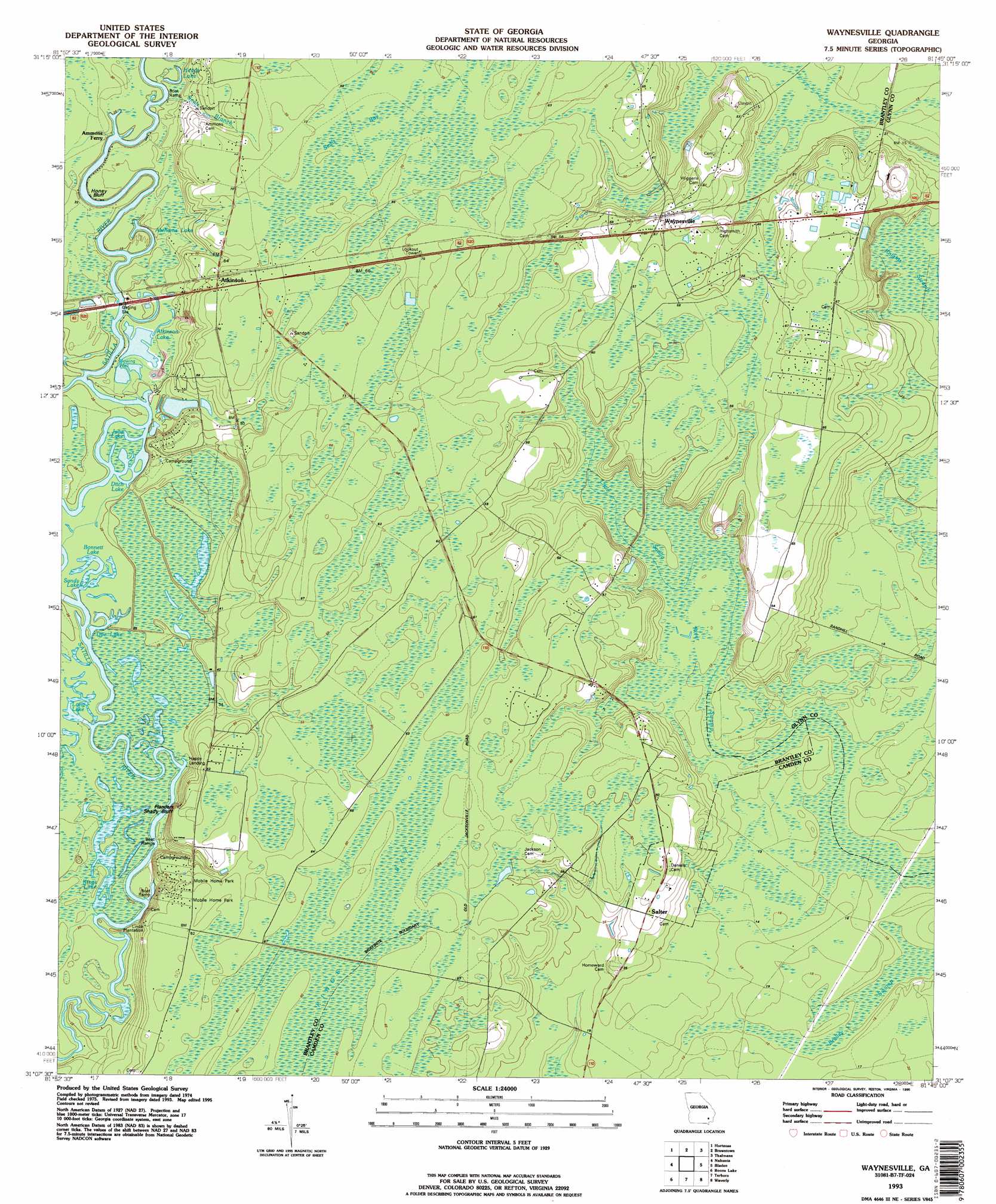
USGS Topo Quad 31081b7 - 1:24,000 scale
| Topo Map Name: | Waynesville |
| USGS Topo Quad ID: | 31081b7 |
| Print Size: | ca. 21 1/4" wide x 27" high |
| Southeast Coordinates: | 31.125° N latitude / 81.75° W longitude |
| Map Center Coordinates: | 31.1875° N latitude / 81.8125° W longitude |
| U.S. State: | GA |
| Filename: | o31081b7.jpg |
| Download Map JPG Image: | Waynesville topo map 1:24,000 scale |
| Map Type: | Topographic |
| Topo Series: | 7.5´ |
| Map Scale: | 1:24,000 |
| Source of Map Images: | United States Geological Survey (USGS) |
| Alternate Map Versions: |
Waynesville GA 1993, updated 1995 Download PDF Buy paper map Waynesville GA 2011 Download PDF Buy paper map Waynesville GA 2014 Download PDF Buy paper map |
1:24,000 Topo Quads surrounding Waynesville
Screven |
Mckinnon |
Manningtown |
Everett |
Cox |
Patterson Se |
Hortense |
Browntown |
Thalmann |
Sterling |
Hoboken East |
Nahunta |
Waynesville |
Bladen |
Brunswick West |
Winokur |
Boons Lake |
Tarboro |
Waverly |
Dover Bluff |
Newell |
Burnt Fort |
Jerusalem |
Woodbine |
Kingsland Ne |
> Back to 31081a1 at 1:100,000 scale
> Back to 31080a1 at 1:250,000 scale
> Back to U.S. Topo Maps home
Waynesville topo map: Gazetteer
Waynesville: Bays
Seals Bay elevation 21m 68′Waynesville: Bridges
Ammons Ferry Bridge (historical) elevation 6m 19′Waynesville: Channels
Abrams Bluff Cut elevation 7m 22′Waynesville: Cliffs
Abrams Bluff elevation 10m 32′Flanders Shady Bluff elevation 17m 55′
Honey Bluff elevation 7m 22′
Lord King Bluff elevation 10m 32′
Radfords Bluff elevation 7m 22′
Waynesville: Dams
Deerwood Lake Dam elevation 9m 29′Waynesville: Lakes
Abrahams Lake elevation 9m 29′Atkinson Lake elevation 8m 26′
Bonnett Lake elevation 7m 22′
Ditch Lake elevation 7m 22′
Doe Lake elevation 6m 19′
Felton Lake elevation 6m 19′
Heads Lake elevation 7m 22′
Julia Lake elevation 7m 22′
Kings Lake elevation 5m 16′
Long Lake elevation 6m 19′
Sandy Lake elevation 6m 19′
Waynesville: Populated Places
Atkinson elevation 18m 59′Coleridge (historical) elevation 6m 19′
Happy Landing elevation 6m 19′
Salter elevation 13m 42′
Waynesville elevation 15m 49′
Waynesville: Post Offices
Waynesville Post Office elevation 13m 42′Waynesville: Reservoirs
Deerwood Lake elevation 9m 29′Waynesville: Streams
Seals Branch elevation 8m 26′Waynesville: Swamps
Brailey Swamp elevation 1m 3′Kings Suck elevation 6m 19′
Knights Swamp elevation 4m 13′
Waynesville digital topo map on disk
Buy this Waynesville topo map showing relief, roads, GPS coordinates and other geographical features, as a high-resolution digital map file on DVD: