Altamaha Sound Topo Map Georgia
To zoom in, hover over the map of Altamaha Sound
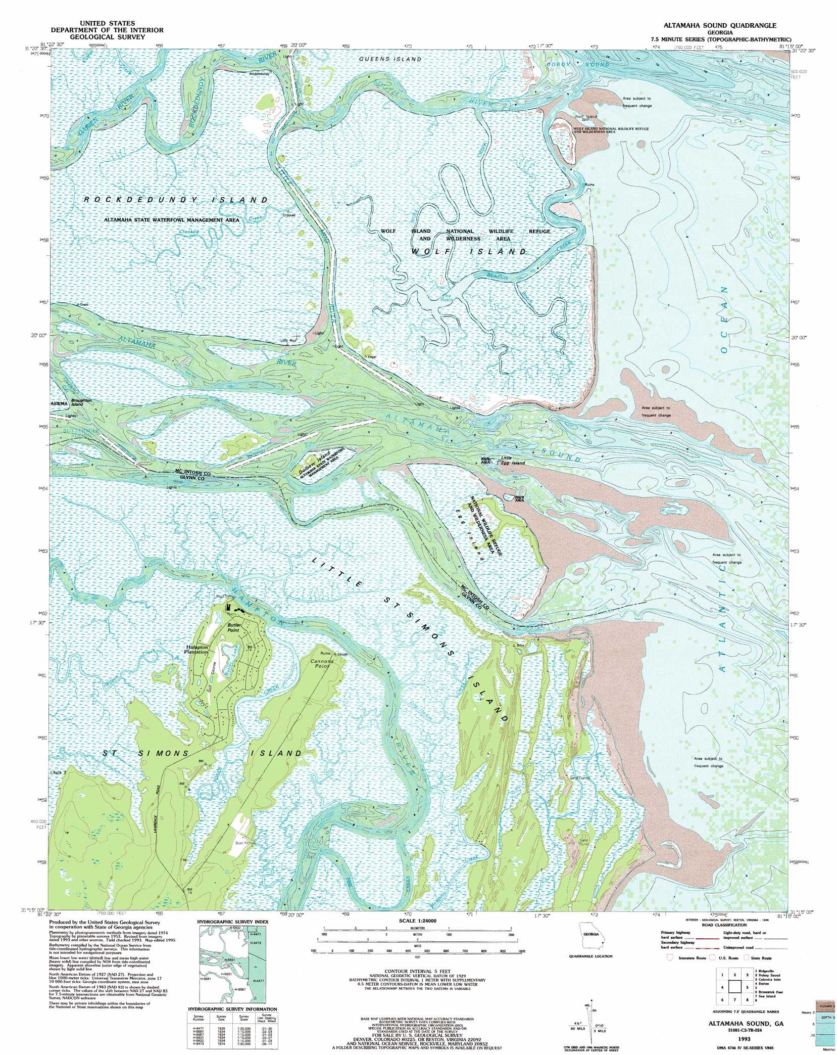
USGS Topo Quad 31081c3 - 1:24,000 scale
| Topo Map Name: | Altamaha Sound |
| USGS Topo Quad ID: | 31081c3 |
| Print Size: | ca. 21 1/4" wide x 27" high |
| Southeast Coordinates: | 31.25° N latitude / 81.25° W longitude |
| Map Center Coordinates: | 31.3125° N latitude / 81.3125° W longitude |
| U.S. State: | GA |
| Filename: | o31081c3.jpg |
| Download Map JPG Image: | Altamaha Sound topo map 1:24,000 scale |
| Map Type: | Topographic |
| Topo Series: | 7.5´ |
| Map Scale: | 1:24,000 |
| Source of Map Images: | United States Geological Survey (USGS) |
| Alternate Map Versions: |
Altamaha Sound GA 1954, updated 1959 Download PDF Buy paper map Altamaha Sound GA 1954, updated 1967 Download PDF Buy paper map Altamaha Sound GA 1979, updated 1979 Download PDF Buy paper map Altamaha Sound GA 1993, updated 1995 Download PDF Buy paper map Altamaha Sound GA 2011 Download PDF Buy paper map Altamaha Sound GA 2014 Download PDF Buy paper map |
1:24,000 Topo Quads surrounding Altamaha Sound
Townsend |
Eulonia |
Shellman Bluff |
Sapelo Sound |
|
Cox |
Ridgeville |
Doboy Sound |
Cabretta Inlet |
|
Sterling |
Darien |
Altamaha Sound |
||
Brunswick West |
Brunswick East |
Sea Island |
||
Dover Bluff |
Jekyll Island |
> Back to 31081a1 at 1:100,000 scale
> Back to 31080a1 at 1:250,000 scale
> Back to U.S. Topo Maps home
Altamaha Sound topo map: Gazetteer
Altamaha Sound: Bars
Wolf Island Spit elevation 0m 0′Altamaha Sound: Bays
Altamaha Sound elevation 0m 0′Altamaha Sound: Bends
Onemile Cut elevation 0m 0′Altamaha Sound: Capes
Butler Point elevation 2m 6′Cannons Point elevation 3m 9′
Altamaha Sound: Channels
Little Mud River elevation 0m 0′Pine Creek elevation 0m 0′
Rockdedundy River elevation 0m 0′
South River elevation 0m 0′
Wolf Creek elevation 0m 0′
Altamaha Sound: Guts
Hospital Creek elevation 0m 0′Altamaha Sound: Islands
Dolbow Island elevation 1m 3′Egg Island elevation 1m 3′
Little Egg Island elevation 0m 0′
Little Saint Simons Island elevation 0m 0′
Rockdedundy Island elevation 0m 0′
Wolf Island elevation 0m 0′
Altamaha Sound: Parks
Altamaha State Waterfowl Management Area elevation 1m 3′Wolf Island National Wildlife Refuge elevation 0m 0′
Altamaha Sound: Streams
Altamaha River elevation 0m 0′Beach Creek elevation 0m 0′
Beacon Creek elevation 1m 3′
Crooked Creek elevation 0m 0′
Darien River elevation 0m 0′
Jones Creek elevation 1m 3′
Old House Creek elevation 0m 0′
Altamaha Sound digital topo map on disk
Buy this Altamaha Sound topo map showing relief, roads, GPS coordinates and other geographical features, as a high-resolution digital map file on DVD: