Sterling Topo Map Georgia
To zoom in, hover over the map of Sterling
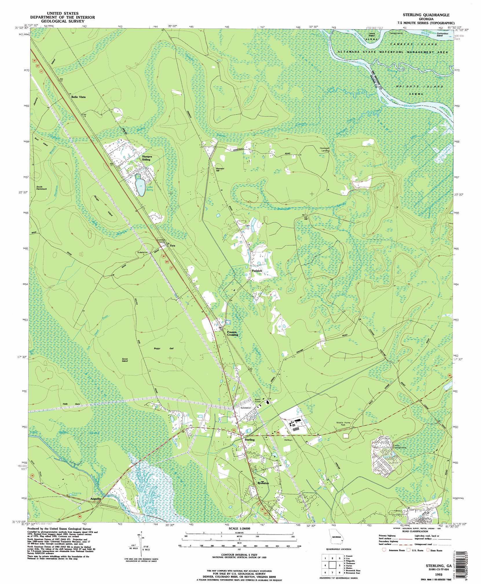
USGS Topo Quad 31081c5 - 1:24,000 scale
| Topo Map Name: | Sterling |
| USGS Topo Quad ID: | 31081c5 |
| Print Size: | ca. 21 1/4" wide x 27" high |
| Southeast Coordinates: | 31.25° N latitude / 81.5° W longitude |
| Map Center Coordinates: | 31.3125° N latitude / 81.5625° W longitude |
| U.S. State: | GA |
| Filename: | o31081c5.jpg |
| Download Map JPG Image: | Sterling topo map 1:24,000 scale |
| Map Type: | Topographic |
| Topo Series: | 7.5´ |
| Map Scale: | 1:24,000 |
| Source of Map Images: | United States Geological Survey (USGS) |
| Alternate Map Versions: |
Sterling GA 1978, updated 1978 Download PDF Buy paper map Sterling GA 1978, updated 1991 Download PDF Buy paper map Sterling GA 1993, updated 1995 Download PDF Buy paper map Sterling GA 2011 Download PDF Buy paper map Sterling GA 2014 Download PDF Buy paper map |
1:24,000 Topo Quads surrounding Sterling
Jesup East |
Bug Island |
Townsend |
Eulonia |
Shellman Bluff |
Manningtown |
Everett |
Cox |
Ridgeville |
Doboy Sound |
Browntown |
Thalmann |
Sterling |
Darien |
Altamaha Sound |
Waynesville |
Bladen |
Brunswick West |
Brunswick East |
Sea Island |
Tarboro |
Waverly |
Dover Bluff |
Jekyll Island |
> Back to 31081a1 at 1:100,000 scale
> Back to 31080a1 at 1:250,000 scale
> Back to U.S. Topo Maps home
Sterling topo map: Gazetteer
Sterling: Channels
Minnow Creek elevation 0m 0′South Branch South Altamaha River elevation 0m 0′
Sterling: Flats
Boggy Gall elevation 4m 13′Sterling: Islands
Cottonbox Island elevation 0m 0′Rough Island elevation 6m 19′
Scrub Island elevation 3m 9′
Wrights Island elevation 0m 0′
Sterling: Lakes
Berry Lake elevation 4m 13′Sterling: Parks
Altamaha Wildlife Management Area elevation 0m 0′Sterling Park elevation 4m 13′
Sterling: Populated Places
Anguilla elevation 3m 9′Brobston elevation 4m 13′
Frazers Crossing elevation 4m 13′
Groveside Park elevation 8m 26′
Live Oak Mobile Home Village elevation 4m 13′
Pennick elevation 5m 16′
Pine Haven elevation 7m 22′
Southern Pines Mobile Home Village elevation 7m 22′
Sterling elevation 3m 9′
Zuta elevation 6m 19′
Sterling: Streams
Cowpen Creek elevation 1m 3′Halfway Creek elevation 1m 3′
Honeygall Creek elevation 0m 0′
Houston Branch elevation 3m 9′
Little Buffalo Swamp elevation 2m 6′
Mill Branch elevation 2m 6′
Oak Head Drain elevation 3m 9′
Tabby Creek elevation 0m 0′
Sterling: Summits
Liz Hill elevation 6m 19′Pennant Hill elevation 6m 19′
Sterling: Swamps
Clayhole Swamp elevation 1m 3′Cowpen Swamp elevation 2m 6′
Green Swamp elevation 4m 13′
Honeygall Swamp elevation 1m 3′
Zuta Branch elevation 4m 13′
Sterling digital topo map on disk
Buy this Sterling topo map showing relief, roads, GPS coordinates and other geographical features, as a high-resolution digital map file on DVD: